Property Record
300 Jenckes Hill Rd, Smithfield, RI 02917
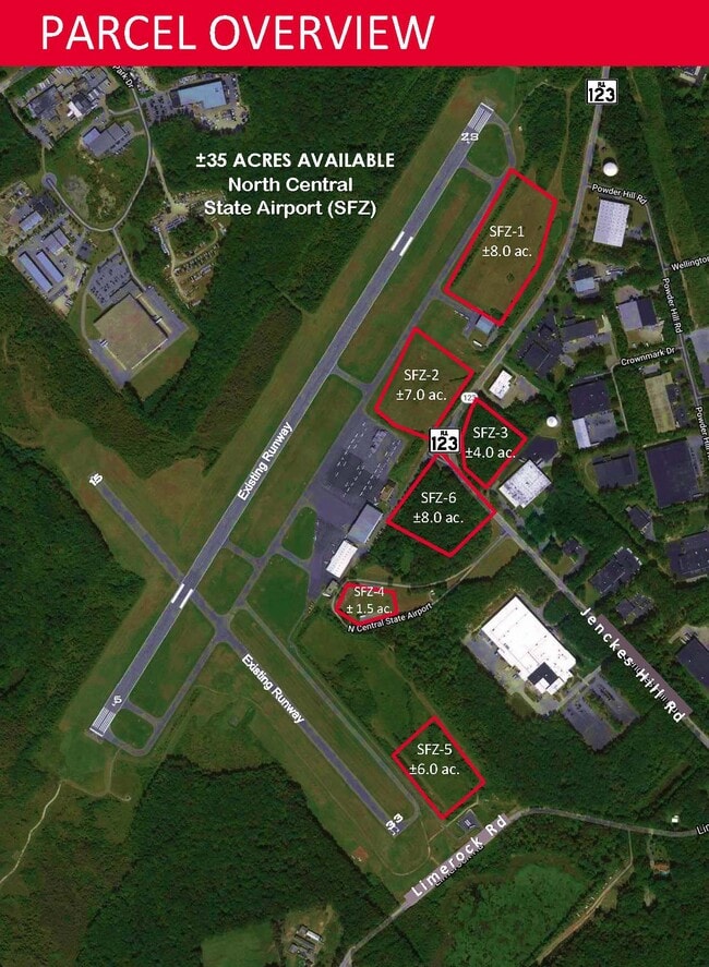
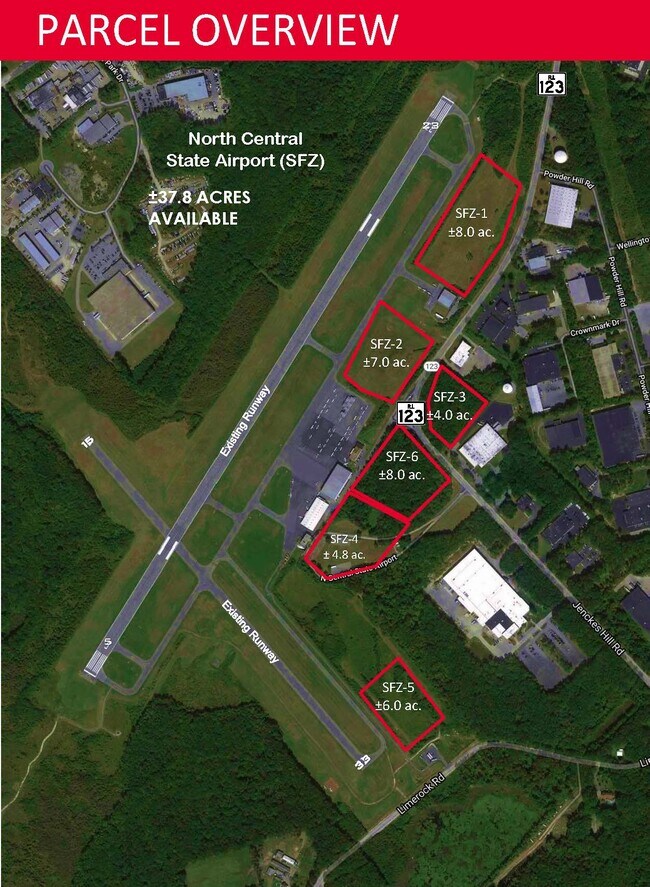
Current Lease Availabilities
NEARBY LISTINGS FOR SALE OR LEASE
Property Detail
300 Jenckes Hill Rd
SMIT-000045-000000-000047
Providence
Stateproperty
Rhode Island
X
47
25005C0100F
315.90 AC
0
Smithfield
2025
Providence
012602
Providence-Warwick, RI-MA
DEMOGRAPHICS near 300 Jenckes Hill Rd
1 Mile
3 Mile
5 Mile
2024 Total Population
444
18,196
108,594
2029 Population
446
18,193
108,487
Pop Growth 2024-2029
+ 0.45%
(0.02%)
(0.10%)
Average Age
47
42
43
2024 Total Households
180
6,570
43,730
HH Growth 2024-2029
+ 0.56%
(0.03%)
(0.19%)
Median Household Inc
$117,187
$108,630
$87,002
Avg Household Size
2.40
2.40
2.40
2024 Avg HH Vehicles
2.00
2.00
2.00
Median Home Value
$477,906
$434,352
$348,105
Median Year Built
1984
1978
1970
Nearby Places
Map Layers
Map Styles
 Street
 Aerial
- Restaurants
- Banks
- Shops
- Fitness
- Groceries
PUBLIC TRANSPORTATION
COMMUTER RAIL
Pawtucket/Central Falls (Foxboro Event Service - MBTA, Providence/Stoughton Line - MBTA)
DRIVE
WALK
Distance
Pawtucket/Central Falls (Foxboro Event Service - MBTA, Providence/Stoughton Line - MBTA)
13 min
7.8 mi
South Attleboro (Providence/Stoughton Line - Massachusetts Bay Transportation Authority Commuter Rail (Purple Line))
DRIVE
WALK
Distance
South Attleboro (Providence/Stoughton Line - Massachusetts Bay Transportation Authority Commuter Rail (Purple Line))
17 min
8.7 mi
AIRPORT
Rhode Island Tf Green International
DRIVE
WALK
Distance
Rhode Island Tf Green International
29 min
17.3 mi
Freight Ports
Port of Davisville, RI
DRIVE
WALK
Distance
Port of Davisville, RI
45 min
30.1 mi
Nearby Properties
Address
Land Use
TOTAL SIZE
Lot Size
Zoning
Address
Land Use
TOTAL SIZE
Lot Size
Zoning
79.96 AC
PC
Address
Land Use
TOTAL SIZE
Lot Size
Zoning
89.07 AC
PD
Address
Land Use
TOTAL SIZE
Lot Size
Zoning
29.60 AC
PC
Address
Land Use
TOTAL SIZE
Lot Size
Zoning
200.05 AC
RA40
Address
Land Use
TOTAL SIZE
Lot Size
Zoning
32.17 AC
PC
Address
Land Use
TOTAL SIZE
Lot Size
Zoning
140,678 SF
37.04 AC
RA40
Address
Land Use
TOTAL SIZE
Lot Size
Zoning
55.86 AC
BL05
Address
Land Use
TOTAL SIZE
Lot Size
Zoning
38.50 AC
RA40
Address
Land Use
TOTAL SIZE
Lot Size
Zoning
247,708 SF
12.14 AC
ML05
Address
Land Use
TOTAL SIZE
Lot Size
Zoning
54.49 AC
RS20
Address
Land Use
TOTAL SIZE
Lot Size
Zoning
115,802 SF
10.30 AC
PC
Address
Land Use
TOTAL SIZE
Lot Size
Zoning
Address
Land Use
TOTAL SIZE
Lot Size
Zoning
Address
Land Use
TOTAL SIZE
Lot Size
Zoning
285,678 SF
25 AC
ML05
Address
Land Use
TOTAL SIZE
Lot Size
Zoning
175,122 SF
22.44 AC
ML05
Address
Land Use
TOTAL SIZE
Lot Size
Zoning
10.27 AC
ML05
Address
Land Use
TOTAL SIZE
Lot Size
Zoning
56,451 SF
5 AC
C
Address
Land Use
TOTAL SIZE
Lot Size
Zoning
119,776 SF
17.33 AC
ML05
Address
Land Use
TOTAL SIZE
Lot Size
Zoning
72.72 AC
PD
Address
Land Use
TOTAL SIZE
Lot Size
Zoning
109,549 SF
19.27 AC
PC
Address
Land Use
TOTAL SIZE
Lot Size
Zoning
123,800 SF
8.31 AC
Address
Land Use
TOTAL SIZE
Lot Size
Zoning
10.09 AC
RG7
Address
Land Use
TOTAL SIZE
Lot Size
Zoning
48,216 SF
9.01 AC
ML05
Address
Land Use
TOTAL SIZE
Lot Size
Zoning
9.73 AC
RG7
Address
Land Use
TOTAL SIZE
Lot Size
Zoning
79,634 SF
8.79 AC
BL05
Address
Land Use
TOTAL SIZE
Lot Size
Zoning
132,005 SF
17.07 AC
ML05
Address
Land Use
TOTAL SIZE
Lot Size
Zoning
64,156 SF
3 AC
PD
Address
Land Use
TOTAL SIZE
Lot Size
Zoning
54,645 SF
13.40 AC
RMED
Address
Land Use
TOTAL SIZE
Lot Size
Zoning
140,616 SF
16.20 AC
I
The World's #1 Commercial Real Estate Marketplace
Connect with us
© 2026 CoStar Group
The information above has been obtained from sources believed reliable. While we do not doubt its accuracy we have not verified it and make no guarantee, warranty or representation about it. It is your responsibility to independently confirm its accuracy and completeness. Any projections, opinions, assumptions, or estimates used are for example only and do not represent the current or future performance of the property. The value of this transaction to you depends on tax and other factors which should be evaluated by your tax, financial, and legal advisors. You and your advisors should conduct a careful, independent investigation of the property to determine to your satisfaction the suitability of the property for your needs.