Property Record
380 Lewiston Rd, Topsham, ME 04086

NEARBY LISTINGS FOR SALE OR LEASE
Property Detail
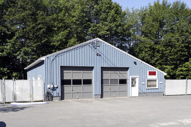
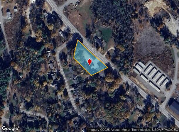
380 Lewiston Rd
TOPM-000001-000000-000055R
Countryside Homes Sub
Commercialbuilding
Sagadahoc
X
Maine
23023C0178F
55
2025
1.12 AC
2025
Sagadahoc County
970301
Portland/South Portland
1,600 SF
Portland-South Portland, ME
DEMOGRAPHICS near 380 Lewiston Rd
1 Mile
3 Mile
5 Mile
2024 Total Population
1,014
10,545
30,000
2029 Population
1,050
10,923
30,960
Pop Growth 2024-2029
+ 3.55%
+ 3.58%
+ 3.20%
Average Age
44
45
44
2024 Total Households
423
4,816
12,594
HH Growth 2024-2029
+ 3.31%
+ 3.57%
+ 3.24%
Median Household Inc
$90,725
$78,000
$76,528
Avg Household Size
2.40
2.10
2.20
2024 Avg HH Vehicles
2.00
2.00
2.00
Median Home Value
$261,363
$302,924
$310,221
Median Year Built
1990
1977
1975
Nearby Places
Map Layers
Map Styles
 Street
 Aerial
- Restaurants
- Banks
- Shops
- Fitness
- Groceries
PUBLIC TRANSPORTATION
COMMUTER RAIL
Brunswick Amtrak Station (Downeaster - Amtrak)
DRIVE
WALK
Distance
Brunswick Amtrak Station (Downeaster - Amtrak)
5 min
3.7 mi
AIRPORT
Portland International Jetport
DRIVE
WALK
Distance
Portland International Jetport
40 min
30.2 mi
Freight Ports
Portland, ME
DRIVE
WALK
Distance
Portland, ME
34 min
27.2 mi
Nearby Properties
Address
Land Use
TOTAL SIZE
Lot Size
Zoning
Address
Land Use
TOTAL SIZE
Lot Size
Zoning
616.11 AC
NO
Address
Land Use
TOTAL SIZE
Lot Size
Zoning
Address
Land Use
TOTAL SIZE
Lot Size
Zoning
199,222 SF
46.56 AC
NO
Address
Land Use
TOTAL SIZE
Lot Size
Zoning
11.05 AC
Address
Land Use
TOTAL SIZE
Lot Size
Zoning
30.78 AC
NO
Address
Land Use
TOTAL SIZE
Lot Size
Zoning
124,514 SF
10.76 AC
NO
Address
Land Use
TOTAL SIZE
Lot Size
Zoning
6,944 SF
0.93 AC
NO
Address
Land Use
TOTAL SIZE
Lot Size
Zoning
413,793 SF
4.94 AC
Address
Land Use
TOTAL SIZE
Lot Size
Zoning
101,903 SF
7.25 AC
NO
Address
Land Use
TOTAL SIZE
Lot Size
Zoning
94,968 SF
16.88 AC
NO
Address
Land Use
TOTAL SIZE
Lot Size
Zoning
78,120 SF
28.71 AC
NO
Address
Land Use
TOTAL SIZE
Lot Size
Zoning
86,743 SF
10.94 AC
NO
Address
Land Use
TOTAL SIZE
Lot Size
Zoning
27,134 SF
2.45 AC
Address
Land Use
TOTAL SIZE
Lot Size
Zoning
60,772 SF
20.56 AC
NO
Address
Land Use
TOTAL SIZE
Lot Size
Zoning
5.14 AC
NO
Address
Land Use
TOTAL SIZE
Lot Size
Zoning
1.04 AC
NO
Address
Land Use
TOTAL SIZE
Lot Size
Zoning
46,303 SF
4.44 AC
NO
Address
Land Use
TOTAL SIZE
Lot Size
Zoning
64,339 SF
6.69 AC
NO
Address
Land Use
TOTAL SIZE
Lot Size
Zoning
111,786 SF
4.20 AC
Address
Land Use
TOTAL SIZE
Lot Size
Zoning
127,816 SF
16.06 AC
GI
Address
Land Use
TOTAL SIZE
Lot Size
Zoning
2.40 AC
NO
Address
Land Use
TOTAL SIZE
Lot Size
Zoning
53.19 AC
NO
Address
Land Use
TOTAL SIZE
Lot Size
Zoning
71,827 SF
19.80 AC
GI
Address
Land Use
TOTAL SIZE
Lot Size
Zoning
33,427 SF
2.91 AC
NO
Address
Land Use
TOTAL SIZE
Lot Size
Zoning
95,145 SF
8.70 AC
GI
Address
Land Use
TOTAL SIZE
Lot Size
Zoning
3.40 AC
NO
Address
Land Use
TOTAL SIZE
Lot Size
Zoning
44,349 SF
3.76 AC
Address
Land Use
TOTAL SIZE
Lot Size
Zoning
6.22 AC
NO
Address
Land Use
TOTAL SIZE
Lot Size
Zoning
36,568 SF
9.41 AC
NO
Address
Land Use
TOTAL SIZE
Lot Size
Zoning
12,906 SF
1.73 AC
The World's #1 Commercial Real Estate Marketplace
Connect with us
© 2025 CoStar Group
The information above has been obtained from sources believed reliable. While we do not doubt its accuracy we have not verified it and make no guarantee, warranty or representation about it. It is your responsibility to independently confirm its accuracy and completeness. Any projections, opinions, assumptions, or estimates used are for example only and do not represent the current or future performance of the property. The value of this transaction to you depends on tax and other factors which should be evaluated by your tax, financial, and legal advisors. You and your advisors should conduct a careful, independent investigation of the property to determine to your satisfaction the suitability of the property for your needs.