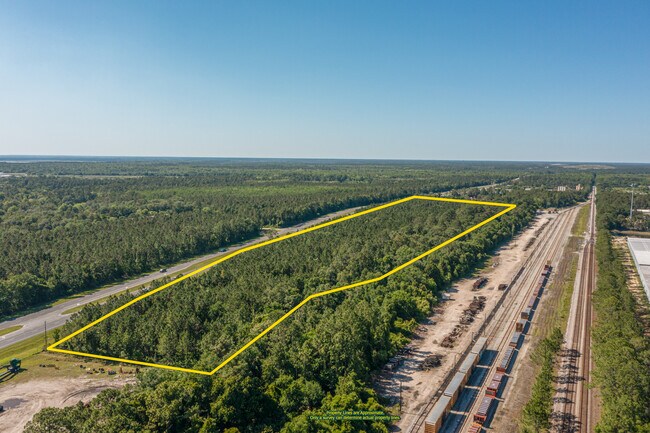
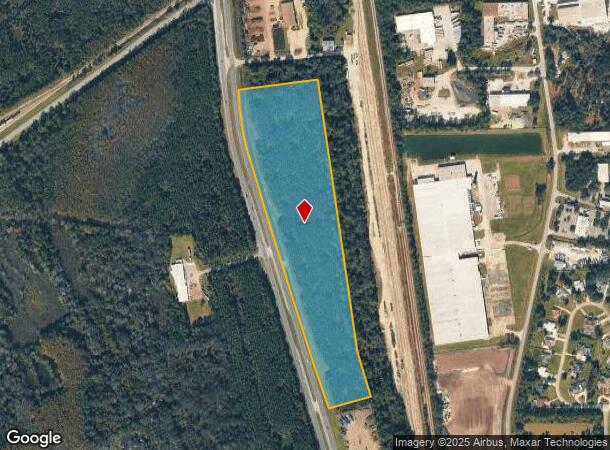
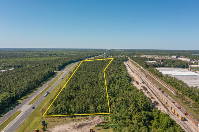
Property Record
380 N Highway 17, Palatka, FL 32177
NEARBY LISTINGS FOR SALE OR LEASE
Property Detail
380 N Highway 17
Palatka, FL
Stinwill Suburban Farms
37-09-26-0000-0060-0090
STINWILL SUBURBAN FARMS MB2, P39 PT OF LOTS 18 19 20 21 +, 22 OR532 P1200(EX OR553 P1229), (MAP SHEET 37D 37E)
Miscellaneous
Putnam
X
Florida
12107C0191C
18
2025
18.05 AC
2025
Florida Central North Area
950700
Other Market Areas
DEMOGRAPHICS near 380 N Highway 17
1 Mile
3 Mile
5 Mile
2024 Total Population
90
9,749
21,652
2029 Population
94
10,060
22,267
Pop Growth 2024-2029
+ 4.44%
+ 3.19%
+ 2.84%
Average Age
34
40
41
2024 Total Households
31
3,786
8,545
HH Growth 2024-2029
+ 3.23%
+ 3.04%
+ 2.70%
Median Household Inc
$37,000
$28,694
$31,306
Avg Household Size
2.90
2.40
2.40
2024 Avg HH Vehicles
2.00
1.00
2.00
Median Home Value
$72,222
$117,219
$140,237
Median Year Built
1977
1971
1975
Nearby Places
Map Layers
Map Styles
 Street
 Aerial
- Restaurants
- Banks
- Shops
- Fitness
- Groceries
PUBLIC TRANSPORTATION
COMMUTER RAIL
Palatka Amtrak (Silver Meteor - Amtrak, Silver Star - Amtrak)
DRIVE
WALK
Distance
Palatka Amtrak (Silver Meteor - Amtrak, Silver Star - Amtrak)
6 min
3.6 mi
Freight Ports
Jacksonville Port
DRIVE
WALK
Distance
Jacksonville Port
81 min
53.9 mi
SALE & LEASE HISTORY
LISTING DATE
SALE/LEASE

Apr 19, 2023
For Sale
Nearby Properties
Address
Land Use
TOTAL SIZE
Lot Size
Zoning
Address
Land Use
TOTAL SIZE
Lot Size
Zoning
211,250 SF
586.70 AC
Address
Land Use
TOTAL SIZE
Lot Size
Zoning
1,242 SF
693.76 AC
Address
Land Use
TOTAL SIZE
Lot Size
Zoning
174,699 SF
41.50 AC
Address
Land Use
TOTAL SIZE
Lot Size
Zoning
7,139 SF
87.49 AC
Address
Land Use
TOTAL SIZE
Lot Size
Zoning
54,720 SF
29.19 AC
Address
Land Use
TOTAL SIZE
Lot Size
Zoning
106,319 SF
28.86 AC
Address
Land Use
TOTAL SIZE
Lot Size
Zoning
97,240 SF
12.72 AC
Address
Land Use
TOTAL SIZE
Lot Size
Zoning
33,616 SF
38.79 AC
Address
Land Use
TOTAL SIZE
Lot Size
Zoning
43,844 SF
31.63 AC
Address
Land Use
TOTAL SIZE
Lot Size
Zoning
75,330 SF
6.63 AC
Address
Land Use
TOTAL SIZE
Lot Size
Zoning
1,120 SF
12.44 AC
Address
Land Use
TOTAL SIZE
Lot Size
Zoning
38,392 SF
21.60 AC
Address
Land Use
TOTAL SIZE
Lot Size
Zoning
1,107 SF
21.57 AC
Address
Land Use
TOTAL SIZE
Lot Size
Zoning
39,660 SF
12.04 AC
Address
Land Use
TOTAL SIZE
Lot Size
Zoning
15.93 AC
Address
Land Use
TOTAL SIZE
Lot Size
Zoning
14,040 SF
14.25 AC
Address
Land Use
TOTAL SIZE
Lot Size
Zoning
10,503 SF
1.98 AC
Address
Land Use
TOTAL SIZE
Lot Size
Zoning
13,825 SF
4.13 AC
Address
Land Use
TOTAL SIZE
Lot Size
Zoning
2,444 SF
29.51 AC
Address
Land Use
TOTAL SIZE
Lot Size
Zoning
75,592 SF
7.87 AC
Address
Land Use
TOTAL SIZE
Lot Size
Zoning
18,895 SF
11.20 AC
Address
Land Use
TOTAL SIZE
Lot Size
Zoning
2,450 SF
26.46 AC
Address
Land Use
TOTAL SIZE
Lot Size
Zoning
6,120 SF
6.32 AC
Address
Land Use
TOTAL SIZE
Lot Size
Zoning
25,124 SF
13.45 AC
Address
Land Use
TOTAL SIZE
Lot Size
Zoning
19,344 SF
4.74 AC
Address
Land Use
TOTAL SIZE
Lot Size
Zoning
57,141 SF
37.09 AC
Address
Land Use
TOTAL SIZE
Lot Size
Zoning
32,222 SF
3.13 AC
Address
Land Use
TOTAL SIZE
Lot Size
Zoning
10,015 SF
2.02 AC
Address
Land Use
TOTAL SIZE
Lot Size
Zoning
33,605 SF
8.46 AC
Address
Land Use
TOTAL SIZE
Lot Size
Zoning
46,062 SF
2.28 AC
The World's #1 Commercial Real Estate Marketplace
Connect with us
© 2026 CoStar Group
The information above has been obtained from sources believed reliable. While we do not doubt its accuracy we have not verified it and make no guarantee, warranty or representation about it. It is your responsibility to independently confirm its accuracy and completeness. Any projections, opinions, assumptions, or estimates used are for example only and do not represent the current or future performance of the property. The value of this transaction to you depends on tax and other factors which should be evaluated by your tax, financial, and legal advisors. You and your advisors should conduct a careful, independent investigation of the property to determine to your satisfaction the suitability of the property for your needs.