Property Record
380 Plymouth Dr, Vista, CA 92083
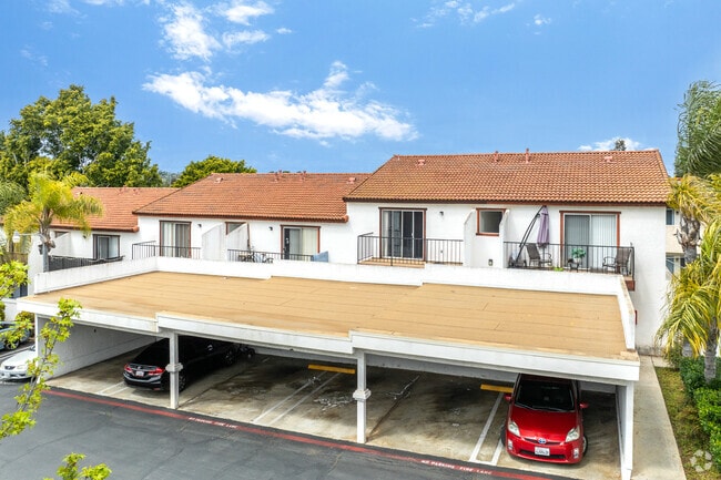

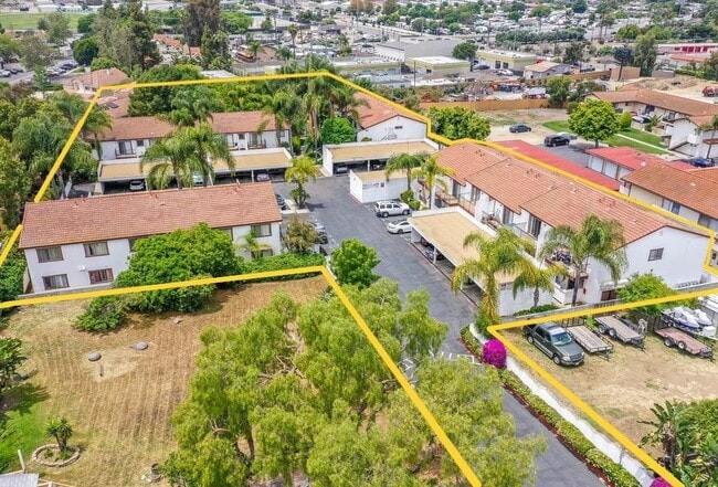

This Property Is For Sale
NEARBY LISTINGS FOR SALE OR LEASE
Property Detail
380 Plymouth Dr
San Diego-Carlsbad, CA
Richardsons Add
163-280-28
LOT 23 (EX RD&DOC77-5793&DOC81-357147)DOC47-16653 IN TR 001501
Multifamilydwelling
San Diego
X
California
06073C0759G
23
2024
1.45 AC
2025
Vista
019503
San Diego
27,168 SF
DEMOGRAPHICS near 380 Plymouth Dr
1 Mile
3 Mile
5 Mile
2024 Total Population
27,050
140,937
264,942
2029 Population
26,877
139,758
262,431
Pop Growth 2024-2029
(0.64%)
(0.84%)
(0.95%)
Average Age
35
39
40
2024 Total Households
7,506
45,843
89,423
HH Growth 2024-2029
(0.83%)
(1.06%)
(1.13%)
Median Household Inc
$70,966
$89,727
$89,833
Avg Household Size
3.30
2.90
2.80
2024 Avg HH Vehicles
2.00
2.00
2.00
Median Home Value
$536,568
$681,347
$688,776
Median Year Built
1977
1982
1984
Nearby Places
Map Layers
Map Styles
 Street
 Aerial
- Restaurants
- Banks
- Shops
- Fitness
- Groceries
PUBLIC TRANSPORTATION
TRANSIT/SUBWAY
Vista Transit Center (Sprinter - San Diego North County Transit District (Coaster/Sprinter/Breeze))
DRIVE
WALK
Distance
Vista Transit Center (Sprinter - San Diego North County Transit District (Coaster/Sprinter/Breeze))
2 min
16 min
0.8 mi
COMMUTER RAIL
Carlsbad Village (Coaster - San Diego North County Transit District (Coaster/Sprinter/Breeze))
DRIVE
WALK
Distance
Carlsbad Village (Coaster - San Diego North County Transit District (Coaster/Sprinter/Breeze))
13 min
8.4 mi
Freight Ports
Port of San Diego
DRIVE
WALK
Distance
Port of San Diego
56 min
44.0 mi
Nearby Properties
Address
Land Use
TOTAL SIZE
Lot Size
Zoning
Address
Land Use
TOTAL SIZE
Lot Size
Zoning
20.96 AC
SP-1-84 (I
Address
Land Use
TOTAL SIZE
Lot Size
Zoning
24.15 AC
RM-B
Address
Land Use
TOTAL SIZE
Lot Size
Zoning
20.10 AC
M-U
Address
Land Use
TOTAL SIZE
Lot Size
Zoning
10.39 AC
M-U (40)
Address
Land Use
TOTAL SIZE
Lot Size
Zoning
18.90 AC
R-M
Address
Land Use
TOTAL SIZE
Lot Size
Zoning
11.17 AC
M-U
Address
Land Use
TOTAL SIZE
Lot Size
Zoning
38.61 AC
PD-1 (IL)
Address
Land Use
TOTAL SIZE
Lot Size
Zoning
21.44 AC
C-1
Address
Land Use
TOTAL SIZE
Lot Size
Zoning
1.23 AC
SPI
Address
Land Use
TOTAL SIZE
Lot Size
Zoning
7.97 AC
SPI-DV
Address
Land Use
TOTAL SIZE
Lot Size
Zoning
7.57 AC
R-M
Address
Land Use
TOTAL SIZE
Lot Size
Zoning
14.91 AC
SPI
Address
Land Use
TOTAL SIZE
Lot Size
Zoning
5.10 AC
R-M
Address
Land Use
TOTAL SIZE
Lot Size
Zoning
9.48 AC
R-M
Address
Land Use
TOTAL SIZE
Lot Size
Zoning
14.08 AC
RH
Address
Land Use
TOTAL SIZE
Lot Size
Zoning
8.67 AC
R-M
Address
Land Use
TOTAL SIZE
Lot Size
Zoning
10.38 AC
R-M
Address
Land Use
TOTAL SIZE
Lot Size
Zoning
6.46 AC
CP
Address
Land Use
TOTAL SIZE
Lot Size
Zoning
6.55 AC
R-M
Address
Land Use
TOTAL SIZE
Lot Size
Zoning
87,472 SF
4.96 AC
RM-A
Address
Land Use
TOTAL SIZE
Lot Size
Zoning
65,156 SF
2.52 AC
PD-1 (IL)
Address
Land Use
TOTAL SIZE
Lot Size
Zoning
9.11 AC
SPI
Address
Land Use
TOTAL SIZE
Lot Size
Zoning
3.32 AC
SPI
Address
Land Use
TOTAL SIZE
Lot Size
Zoning
10.59 AC
RH
Address
Land Use
TOTAL SIZE
Lot Size
Zoning
3.99 AC
M-U
Address
Land Use
TOTAL SIZE
Lot Size
Zoning
58,256 SF
5.67 AC
RM-A
Address
Land Use
TOTAL SIZE
Lot Size
Zoning
1.92 AC
C-2
Address
Land Use
TOTAL SIZE
Lot Size
Zoning
25.57 AC
C-2
Address
Land Use
TOTAL SIZE
Lot Size
Zoning
4.34 AC
SP-08
Address
Land Use
TOTAL SIZE
Lot Size
Zoning
12 AC
SPI
The World's #1 Commercial Real Estate Marketplace
Connect with us
© 2026 CoStar Group
The information above has been obtained from sources believed reliable. While we do not doubt its accuracy we have not verified it and make no guarantee, warranty or representation about it. It is your responsibility to independently confirm its accuracy and completeness. Any projections, opinions, assumptions, or estimates used are for example only and do not represent the current or future performance of the property. The value of this transaction to you depends on tax and other factors which should be evaluated by your tax, financial, and legal advisors. You and your advisors should conduct a careful, independent investigation of the property to determine to your satisfaction the suitability of the property for your needs.