Property Record
225 N Smith Rd, Bloomington, IN 47408
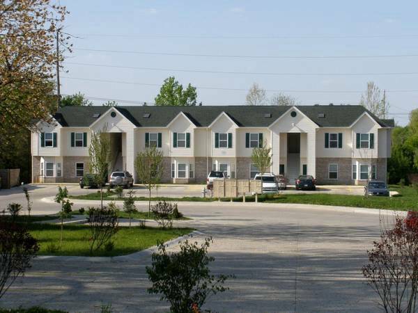


This Property Is For Sale
NEARBY LISTINGS FOR SALE OR LEASE
Property Detail
225 N Smith Rd
53-05-35-400-010.000-005
013-35860-00 PT E1/2 SE 35-9-1W 3.88A PLAT 70 SHAMROCK POINT APARTMENTS
Apartment
Monroe
X
Indiana
18105C0161D
3.88 AC
2024
Bloomington/Terre Haute
2024
Other Market Areas
000903
Bloomington, IN
4,336 SF
DEMOGRAPHICS near 225 N Smith Rd
1 mile
3 mile
5 mile
2024 Total Population
9,117
55,046
91,912
2029 Population
8,987
54,785
91,630
Pop Growth 2024-2029
(1.43%)
(0.47%)
(0.31%)
Average Age
37
32
34
2024 Total Households
4,588
22,007
39,017
HH Growth 2024-2029
(1.57%)
(0.50%)
(0.34%)
Median Household Inc
$40,458
$33,103
$42,743
Avg Household Size
2.00
2.00
2.00
2024 Avg HH Vehicles
1.00
2.00
2.00
Median Home Value
$279,738
$318,375
$261,925
Median Year Built
1982
1986
1987
Nearby Places
Map Layers
Map Styles
 Street
 Aerial
Transit
 Traffic
 Biking
Places
Listings with unknown addresses are not visible on the map
- Restaurants
- Banks
- Shops
- Fitness
- Groceries
Nearby Properties
Address
Land Use
TOTAL SIZE
Lot Size
Zoning
Address
Land Use
TOTAL SIZE
Lot Size
Zoning
7,804 SF
7.22 AC
Address
Land Use
TOTAL SIZE
Lot Size
Zoning
496,556 SF
1.73 AC
Address
Land Use
TOTAL SIZE
Lot Size
Zoning
8,107 SF
12.37 AC
Address
Land Use
TOTAL SIZE
Lot Size
Zoning
13,910 SF
3.86 AC
Address
Land Use
TOTAL SIZE
Lot Size
Zoning
Address
Land Use
TOTAL SIZE
Lot Size
Zoning
812 SF
19.97 AC
Address
Land Use
TOTAL SIZE
Lot Size
Zoning
Address
Land Use
TOTAL SIZE
Lot Size
Zoning
261,278 SF
4.62 AC
Address
Land Use
TOTAL SIZE
Lot Size
Zoning
10,573 SF
3.28 AC
Address
Land Use
TOTAL SIZE
Lot Size
Zoning
8,064 SF
1.29 AC
Address
Land Use
TOTAL SIZE
Lot Size
Zoning
404,051 SF
36.54 AC
Address
Land Use
TOTAL SIZE
Lot Size
Zoning
4,895 SF
16.61 AC
Address
Land Use
TOTAL SIZE
Lot Size
Zoning
169,170 SF
0.72 AC
Address
Land Use
TOTAL SIZE
Lot Size
Zoning
3,934 SF
21.23 AC
Address
Land Use
TOTAL SIZE
Lot Size
Zoning
5,908 SF
19.52 AC
Address
Land Use
TOTAL SIZE
Lot Size
Zoning
134,566 SF
0.60 AC
Address
Land Use
TOTAL SIZE
Lot Size
Zoning
5,482 SF
17.05 AC
RE25
Address
Land Use
TOTAL SIZE
Lot Size
Zoning
7,500 SF
0.40 AC
Address
Land Use
TOTAL SIZE
Lot Size
Zoning
181,798 SF
0.80 AC
Address
Land Use
TOTAL SIZE
Lot Size
Zoning
32,737 SF
0.93 AC
Address
Land Use
TOTAL SIZE
Lot Size
Zoning
2,000 SF
6.74 AC
Address
Land Use
TOTAL SIZE
Lot Size
Zoning
2,219 SF
30.79 AC
Address
Land Use
TOTAL SIZE
Lot Size
Zoning
404,051 SF
25.72 AC
Address
Land Use
TOTAL SIZE
Lot Size
Zoning
17,312 SF
31.90 AC
Address
Land Use
TOTAL SIZE
Lot Size
Zoning
38,208 SF
8.03 AC
Address
Land Use
TOTAL SIZE
Lot Size
Zoning
17,016 SF
1.40 AC
Address
Land Use
TOTAL SIZE
Lot Size
Zoning
6,480 SF
10.73 AC
Address
Land Use
TOTAL SIZE
Lot Size
Zoning
9,128 SF
22.86 AC
Address
Land Use
TOTAL SIZE
Lot Size
Zoning
8,439 SF
18.94 AC
Address
Land Use
TOTAL SIZE
Lot Size
Zoning
22,654 SF
5.36 AC
The World's #1 Commercial Real Estate Marketplace
Connect with us
© 2026 CoStar Group
The information above has been obtained from sources believed reliable. While we do not doubt its accuracy we have not verified it and make no guarantee, warranty or representation about it. It is your responsibility to independently confirm its accuracy and completeness. Any projections, opinions, assumptions, or estimates used are for example only and do not represent the current or future performance of the property. The value of this transaction to you depends on tax and other factors which should be evaluated by your tax, financial, and legal advisors. You and your advisors should conduct a careful, independent investigation of the property to determine to your satisfaction the suitability of the property for your needs.