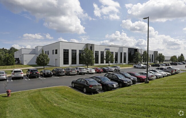
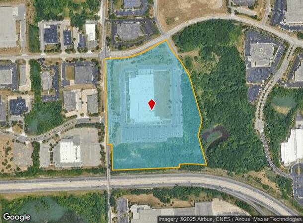
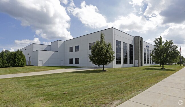
Property Record
3800 Giddings Rd, Auburn Hills, MI 48326
NEARBY LISTINGS FOR SALE OR LEASE
Property Detail
3800 Giddings Rd
14-03-401-006
T3N, R10E, SEC 3 PART OF E 1/2 OF SEC BEG AT PT DIST S 00-15-00 W 43 FT & S 89-42-11 W 99.59 FT & N 77-57-31 W 311.04 FT & N
Manufacturinglight
Oakland
X
Michigan
26125C0359F
31.37 AC
2024
Auburn Hills, Pontiac & Rochester
2025
Detroit
981400
Detroit-Warren-Dearborn, MI
173,974 SF
DEMOGRAPHICS near 3800 Giddings Rd
1 Mile
3 Mile
5 Mile
2024 Total Population
518
46,980
134,435
2029 Population
528
46,918
134,079
Pop Growth 2024-2029
+ 1.93%
(0.13%)
(0.26%)
Average Age
40
37
39
2024 Total Households
213
18,210
51,538
HH Growth 2024-2029
+ 1.88%
(0.19%)
(0.29%)
Median Household Inc
$75,625
$65,865
$71,933
Avg Household Size
2.40
2.40
2.50
2024 Avg HH Vehicles
2.00
2.00
2.00
Median Home Value
$232,500
$256,342
$296,062
Median Year Built
2003
1983
1978
Nearby Places
Map Layers
Map Styles
 Street
 Aerial
- Restaurants
- Banks
- Shops
- Fitness
- Groceries
PUBLIC TRANSPORTATION
COMMUTER RAIL
Pontiac Amtrak Station (Wolverine - Amtrak)
DRIVE
WALK
Distance
Pontiac Amtrak Station (Wolverine - Amtrak)
12 min
5.5 mi
Freight Ports
Port of Toledo
DRIVE
WALK
Distance
Port of Toledo
113 min
92.5 mi
Nearby Properties
Address
Land Use
TOTAL SIZE
Lot Size
Zoning
Address
Land Use
TOTAL SIZE
Lot Size
Zoning
6,255,758 SF
Address
Land Use
TOTAL SIZE
Lot Size
Zoning
1,421,000 SF
170.30 AC
B2
Address
Land Use
TOTAL SIZE
Lot Size
Zoning
238,755 SF
Address
Land Use
TOTAL SIZE
Lot Size
Zoning
715,400 SF
Address
Land Use
TOTAL SIZE
Lot Size
Zoning
316,358 SF
20.89 AC
P
Address
Land Use
TOTAL SIZE
Lot Size
Zoning
527,000 SF
36.03 AC
Address
Land Use
TOTAL SIZE
Lot Size
Zoning
891,314 SF
60.90 AC
II
Address
Land Use
TOTAL SIZE
Lot Size
Zoning
420,858 SF
65.07 AC
Address
Land Use
TOTAL SIZE
Lot Size
Zoning
430,338 SF
46.09 AC
Address
Land Use
TOTAL SIZE
Lot Size
Zoning
238,755 SF
18.12 AC
Address
Land Use
TOTAL SIZE
Lot Size
Zoning
1,771,589 SF
96.73 AC
Address
Land Use
TOTAL SIZE
Lot Size
Zoning
247,500 SF
Address
Land Use
TOTAL SIZE
Lot Size
Zoning
6,255,758 SF
223.95 AC
Address
Land Use
TOTAL SIZE
Lot Size
Zoning
6,255,758 SF
233.05 AC
II
Address
Land Use
TOTAL SIZE
Lot Size
Zoning
246,150 SF
26.64 AC
TR
Address
Land Use
TOTAL SIZE
Lot Size
Zoning
6,255,758 SF
Address
Land Use
TOTAL SIZE
Lot Size
Zoning
487,797 SF
34.74 AC
TR
Address
Land Use
TOTAL SIZE
Lot Size
Zoning
278,387 SF
43.37 AC
Address
Land Use
TOTAL SIZE
Lot Size
Zoning
214,772 SF
Address
Land Use
TOTAL SIZE
Lot Size
Zoning
430,338 SF
43.22 AC
Address
Land Use
TOTAL SIZE
Lot Size
Zoning
280,000 SF
Address
Land Use
TOTAL SIZE
Lot Size
Zoning
213,112 SF
12.17 AC
I1
Address
Land Use
TOTAL SIZE
Lot Size
Zoning
144,349 SF
12.42 AC
SP
Address
Land Use
TOTAL SIZE
Lot Size
Zoning
347,979 SF
58.38 AC
AI
Address
Land Use
TOTAL SIZE
Lot Size
Zoning
329,335 SF
17.40 AC
Address
Land Use
TOTAL SIZE
Lot Size
Zoning
455,045 SF
23.47 AC
I1
Address
Land Use
TOTAL SIZE
Lot Size
Zoning
101,568 SF
8.06 AC
Address
Land Use
TOTAL SIZE
Lot Size
Zoning
172,076 SF
11.18 AC
Address
Land Use
TOTAL SIZE
Lot Size
Zoning
278,387 SF
Address
Land Use
TOTAL SIZE
Lot Size
Zoning
135,230 SF
The World's #1 Commercial Real Estate Marketplace
Connect with us
© 2026 CoStar Group
The information above has been obtained from sources believed reliable. While we do not doubt its accuracy we have not verified it and make no guarantee, warranty or representation about it. It is your responsibility to independently confirm its accuracy and completeness. Any projections, opinions, assumptions, or estimates used are for example only and do not represent the current or future performance of the property. The value of this transaction to you depends on tax and other factors which should be evaluated by your tax, financial, and legal advisors. You and your advisors should conduct a careful, independent investigation of the property to determine to your satisfaction the suitability of the property for your needs.