Property Record
38000 Cargill Way, Dade City, FL 33523
NEARBY LISTINGS FOR SALE OR LEASE
Property Detail
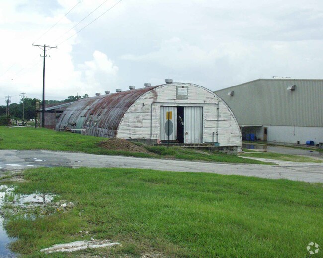
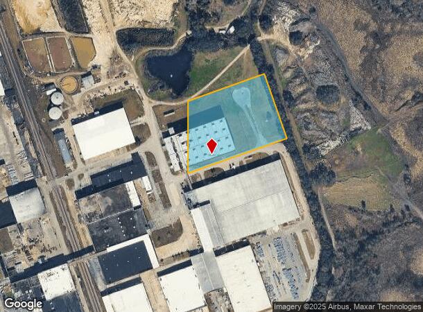
38000 Cargill Way
Tampa-St. Petersburg-Clearwater, FL
U.S. 301
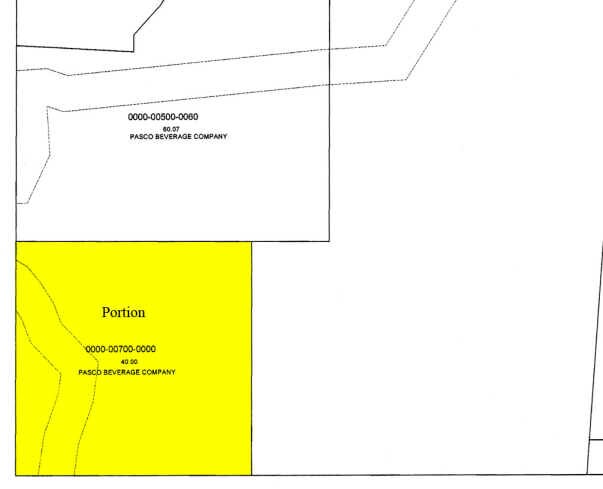
23-24-21-0000-00700-0010
THAT POR OF FOLLOWING DESC PROPERTY LYING WITHIN SEC 23 COM AT CENTER OF SEC 22 TH S00DEG2146W 2652.54 FT TO SW COR OF SE 1/4 TH N89DEG57 06E 2304.25 FT TH N19DEG14 18W 1927.59 FT TH N89DEG5826 E 991.86 FT TO EAST LINE OF SE 1/4 TH S00DEG2238W 361.26
Heavyindustrial
Pasco
AE
Florida
12101C0120F
1
2024
3.55 AC
2026
Pasco County
032401
Tampa/St Petersburg
56,028 SF
DEMOGRAPHICS near 38000 Cargill Way
1 Mile
3 Mile
5 Mile
2024 Total Population
5,083
16,939
28,757
2029 Population
6,181
20,556
34,653
Pop Growth 2024-2029
+ 21.60%
+ 21.35%
+ 20.50%
Average Age
37
39
41
2024 Total Households
1,713
6,033
10,539
HH Growth 2024-2029
+ 21.83%
+ 21.38%
+ 20.84%
Median Household Inc
$53,048
$55,071
$58,433
Avg Household Size
2.70
2.60
2.50
2024 Avg HH Vehicles
2.00
2.00
2.00
Median Home Value
$116,601
$189,094
$226,324
Median Year Built
1972
1980
1984
Nearby Places
Map Layers
Map Styles
 Street
 Aerial
- Restaurants
- Banks
- Shops
- Fitness
- Groceries
Nearby Properties
Address
Land Use
TOTAL SIZE
Lot Size
Zoning
Address
Land Use
TOTAL SIZE
Lot Size
Zoning
191,025 SF
27.54 AC
RIO
Address
Land Use
TOTAL SIZE
Lot Size
Zoning
119,784 SF
7.79 AC
RIO
Address
Land Use
TOTAL SIZE
Lot Size
Zoning
118,676 SF
80.02 AC
RIO
Address
Land Use
TOTAL SIZE
Lot Size
Zoning
80,036 SF
12 AC
C2
Address
Land Use
TOTAL SIZE
Lot Size
Zoning
98,666 SF
19.80 AC
RIO
Address
Land Use
TOTAL SIZE
Lot Size
Zoning
320,071 SF
23.74 AC
PDEC
Address
Land Use
TOTAL SIZE
Lot Size
Zoning
82,689 SF
19.18 AC
RG1
Address
Land Use
TOTAL SIZE
Lot Size
Zoning
76,418 SF
2.78 AC
RIO
Address
Land Use
TOTAL SIZE
Lot Size
Zoning
84,706 SF
13.65 AC
RIO
Address
Land Use
TOTAL SIZE
Lot Size
Zoning
16,994 SF
2.40 AC
CG
Address
Land Use
TOTAL SIZE
Lot Size
Zoning
111,677 SF
10.40 AC
CG
Address
Land Use
TOTAL SIZE
Lot Size
Zoning
33,580 SF
6.09 AC
RIO
Address
Land Use
TOTAL SIZE
Lot Size
Zoning
88,358 SF
36.68 AC
OUA
Address
Land Use
TOTAL SIZE
Lot Size
Zoning
86,138 SF
6.62 AC
CG
Address
Land Use
TOTAL SIZE
Lot Size
Zoning
70,032 SF
12.80 AC
MPUD
Address
Land Use
TOTAL SIZE
Lot Size
Zoning
37,368 SF
10.82 AC
CG
Address
Land Use
TOTAL SIZE
Lot Size
Zoning
64,520 SF
11.65 AC
I2
Address
Land Use
TOTAL SIZE
Lot Size
Zoning
65,354 SF
15 AC
RIO
Address
Land Use
TOTAL SIZE
Lot Size
Zoning
95,673 SF
7.51 AC
PDH2
Address
Land Use
TOTAL SIZE
Lot Size
Zoning
36,518 SF
2.77 AC
CG
Address
Land Use
TOTAL SIZE
Lot Size
Zoning
131,580 SF
3.84 AC
PDEC
Address
Land Use
TOTAL SIZE
Lot Size
Zoning
44,210 SF
7.10 AC
C2
Address
Land Use
TOTAL SIZE
Lot Size
Zoning
32,530 SF
33 AC
RIO
Address
Land Use
TOTAL SIZE
Lot Size
Zoning
35,904 SF
5.19 AC
RS1
Address
Land Use
TOTAL SIZE
Lot Size
Zoning
130,200 SF
0.74 AC
CBD
Address
Land Use
TOTAL SIZE
Lot Size
Zoning
112,952 SF
13.03 AC
MF1
Address
Land Use
TOTAL SIZE
Lot Size
Zoning
41,400 SF
4.91 AC
PDEC
Address
Land Use
TOTAL SIZE
Lot Size
Zoning
132,517 SF
10.26 AC
I2
Address
Land Use
TOTAL SIZE
Lot Size
Zoning
37,024 SF
5 AC
RIO
Address
Land Use
TOTAL SIZE
Lot Size
Zoning
20,070 SF
1.62 AC
CBD
The World's #1 Commercial Real Estate Marketplace
Connect with us
© 2026 CoStar Group
The information above has been obtained from sources believed reliable. While we do not doubt its accuracy we have not verified it and make no guarantee, warranty or representation about it. It is your responsibility to independently confirm its accuracy and completeness. Any projections, opinions, assumptions, or estimates used are for example only and do not represent the current or future performance of the property. The value of this transaction to you depends on tax and other factors which should be evaluated by your tax, financial, and legal advisors. You and your advisors should conduct a careful, independent investigation of the property to determine to your satisfaction the suitability of the property for your needs.