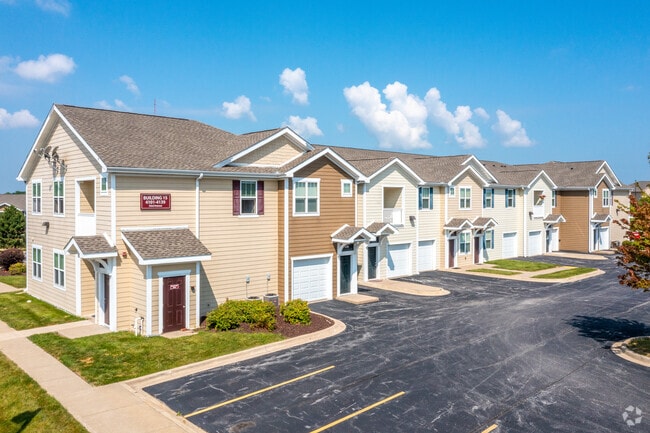
Property Record
3801 53Rd Ave, Bettendorf, IA 52722
NEARBY LISTINGS FOR SALE OR LEASE
Property Detail
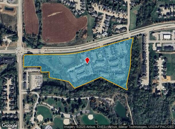
3801 53Rd Ave
Davenport-Moline-Rock Island, IA-IL
Springs At Bettendorf 2Nd Add
841037101ABC
SPRINGS AT BETTENDORF 2ND ADD LOT: 001 SPRINGS AT BETTENDORF 2ND ADD LOTS 1, A, B, C & LOT C 1ST ADD
Multifamilydwelling
Scott
AE
Iowa
19163C0378H
1,c
2025
29.48 AC
2025
Outer Davenport/Bettendorf
013706
Davenport/Moline/Rock Island
2,045 SF
DEMOGRAPHICS near 3801 53Rd Ave
1 Mile
3 Mile
5 Mile
2024 Total Population
9,048
39,890
86,695
2029 Population
9,158
39,855
86,129
Pop Growth 2024-2029
+ 1.22%
(0.09%)
(0.65%)
Average Age
39
40
40
2024 Total Households
3,413
15,691
35,530
HH Growth 2024-2029
+ 1.17%
(0.15%)
(0.74%)
Median Household Inc
$139,958
$102,123
$76,794
Avg Household Size
2.60
2.50
2.40
2024 Avg HH Vehicles
2.00
2.00
2.00
Median Home Value
$381,554
$286,759
$223,968
Median Year Built
2009
1987
1973
Nearby Places
Map Layers
Map Styles
 Street
 Aerial
- Restaurants
- Banks
- Shops
- Fitness
- Groceries
PUBLIC TRANSPORTATION
AIRPORT
Quad Cities International
DRIVE
WALK
Distance
Quad Cities International
36 min
18.7 mi
Freight Ports
Port Milwaukee
DRIVE
WALK
Distance
Port Milwaukee
235 min
206.9 mi
Nearby Properties
Address
Land Use
TOTAL SIZE
Lot Size
Zoning
Address
Land Use
TOTAL SIZE
Lot Size
Zoning
157,587 SF
33.92 AC
Address
Land Use
TOTAL SIZE
Lot Size
Zoning
247,196 SF
13.39 AC
Address
Land Use
TOTAL SIZE
Lot Size
Zoning
9,000 SF
408.98 AC
Address
Land Use
TOTAL SIZE
Lot Size
Zoning
5,400 SF
76.68 AC
Address
Land Use
TOTAL SIZE
Lot Size
Zoning
4,518 SF
6.27 AC
Address
Land Use
TOTAL SIZE
Lot Size
Zoning
50,882 SF
5.10 AC
Address
Land Use
TOTAL SIZE
Lot Size
Zoning
5,296 SF
67.13 AC
Address
Land Use
TOTAL SIZE
Lot Size
Zoning
1,800 SF
60.86 AC
Address
Land Use
TOTAL SIZE
Lot Size
Zoning
133,809 SF
8.26 AC
Address
Land Use
TOTAL SIZE
Lot Size
Zoning
4,944 SF
17.91 AC
Address
Land Use
TOTAL SIZE
Lot Size
Zoning
111,979 SF
6.86 AC
Address
Land Use
TOTAL SIZE
Lot Size
Zoning
156,632 SF
17.67 AC
Address
Land Use
TOTAL SIZE
Lot Size
Zoning
71,820 SF
5.71 AC
Address
Land Use
TOTAL SIZE
Lot Size
Zoning
64,661 SF
147.01 AC
Address
Land Use
TOTAL SIZE
Lot Size
Zoning
3,543 SF
14.79 AC
Address
Land Use
TOTAL SIZE
Lot Size
Zoning
84,002 SF
21.76 AC
Address
Land Use
TOTAL SIZE
Lot Size
Zoning
226,764 SF
23.52 AC
Address
Land Use
TOTAL SIZE
Lot Size
Zoning
69,519 SF
5.49 AC
Address
Land Use
TOTAL SIZE
Lot Size
Zoning
118,130 SF
9.32 AC
Address
Land Use
TOTAL SIZE
Lot Size
Zoning
67,813 SF
2.56 AC
Address
Land Use
TOTAL SIZE
Lot Size
Zoning
165,770 SF
13.77 AC
Address
Land Use
TOTAL SIZE
Lot Size
Zoning
54,606 SF
7.68 AC
Address
Land Use
TOTAL SIZE
Lot Size
Zoning
15,353 SF
3.73 AC
Address
Land Use
TOTAL SIZE
Lot Size
Zoning
61,794 SF
8.83 AC
Address
Land Use
TOTAL SIZE
Lot Size
Zoning
105,195 SF
10.37 AC
Address
Land Use
TOTAL SIZE
Lot Size
Zoning
13,198 SF
11.11 AC
Address
Land Use
TOTAL SIZE
Lot Size
Zoning
42,524 SF
7.18 AC
Address
Land Use
TOTAL SIZE
Lot Size
Zoning
147,767 SF
10.48 AC
Address
Land Use
TOTAL SIZE
Lot Size
Zoning
53,320 SF
4.36 AC
The World's #1 Commercial Real Estate Marketplace
Connect with us
© 2026 CoStar Group
The information above has been obtained from sources believed reliable. While we do not doubt its accuracy we have not verified it and make no guarantee, warranty or representation about it. It is your responsibility to independently confirm its accuracy and completeness. Any projections, opinions, assumptions, or estimates used are for example only and do not represent the current or future performance of the property. The value of this transaction to you depends on tax and other factors which should be evaluated by your tax, financial, and legal advisors. You and your advisors should conduct a careful, independent investigation of the property to determine to your satisfaction the suitability of the property for your needs.