Property Record
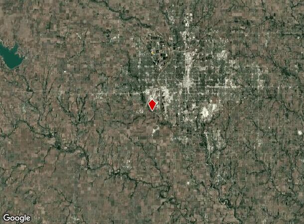
3801 N Ridge Rd, Wichita, KS 67205
NEARBY LISTINGS FOR SALE OR LEASE
-
-
View all Wichita listings for sale on LoopNet.com
Property Detail
3801 N Ridge Rd
Wichita, KS
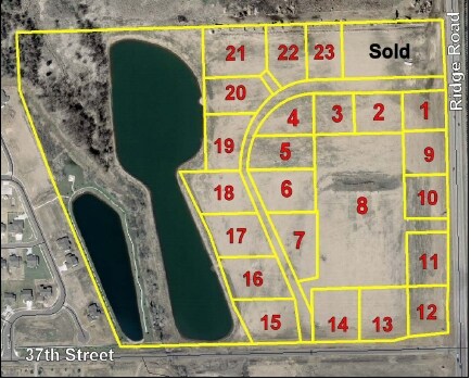
Northridge Plaza Add
088-28-0-44-01-010.00
LOT 8 BLOCK A NORTHRIDGE PLAZA ADD.
Storebuilding
Sedgwick
X
Kansas
20173C0193G
8
2024
1.16 AC
2025
Outlying Sedgwick County
009605
Wichita
31,771 SF
DEMOGRAPHICS near 3801 N Ridge Rd
1 Mile
3 Mile
5 Mile
2024 Total Population
5,664
32,508
107,971
2029 Population
5,823
33,096
109,574
Pop Growth 2024-2029
+ 2.81%
+ 1.81%
+ 1.48%
Average Age
38
39
40
2024 Total Households
1,957
11,828
43,284
HH Growth 2024-2029
+ 2.91%
+ 1.75%
+ 1.48%
Median Household Inc
$110,863
$90,011
$65,238
Avg Household Size
2.80
2.70
2.40
2024 Avg HH Vehicles
2.00
2.00
2.00
Median Home Value
$260,810
$251,135
$185,185
Median Year Built
2007
2000
1981
Nearby Places
Map Layers
Map Styles
 Street
 Aerial
- Restaurants
- Banks
- Shops
- Fitness
- Groceries
PUBLIC TRANSPORTATION
AIRPORT
Wichita Dwight D Eisenhower Ntl
DRIVE
WALK
Distance
Wichita Dwight D Eisenhower Ntl
15 min
6.2 mi
Freight Ports
Tulsa Port Of Catoosa
DRIVE
WALK
Distance
Tulsa Port Of Catoosa
208 min
194.3 mi
Nearby Properties
Address
Land Use
TOTAL SIZE
Lot Size
Zoning
Address
Land Use
TOTAL SIZE
Lot Size
Zoning
1,675,141 SF
1,753.52 AC
LI
Address
Land Use
TOTAL SIZE
Lot Size
Zoning
456,792 SF
155.67 AC
LI
Address
Land Use
TOTAL SIZE
Lot Size
Zoning
233,806 SF
54.14 AC
LC
Address
Land Use
TOTAL SIZE
Lot Size
Zoning
84,959 SF
2 AC
LI
Address
Land Use
TOTAL SIZE
Lot Size
Zoning
395,143 SF
3.58 AC
LI
Address
Land Use
TOTAL SIZE
Lot Size
Zoning
55,930 SF
10.28 AC
LI
Address
Land Use
TOTAL SIZE
Lot Size
Zoning
1,677,015 SF
49.80 AC
LI,SF-20
Address
Land Use
TOTAL SIZE
Lot Size
Zoning
60,900 SF
281.77 AC
SF-5
Address
Land Use
TOTAL SIZE
Lot Size
Zoning
72,114 SF
47.10 AC
SF-5
Address
Land Use
TOTAL SIZE
Lot Size
Zoning
58,588 SF
11.08 AC
SF-5
Address
Land Use
TOTAL SIZE
Lot Size
Zoning
58,392 SF
6.34 AC
LI
Address
Land Use
TOTAL SIZE
Lot Size
Zoning
86,606 SF
7.51 AC
SF-20
Address
Land Use
TOTAL SIZE
Lot Size
Zoning
53,402 SF
26.35 AC
SF-5
Address
Land Use
TOTAL SIZE
Lot Size
Zoning
42,983 SF
5.67 AC
SF-5
Address
Land Use
TOTAL SIZE
Lot Size
Zoning
36,460 SF
22.57 AC
SF-5
Address
Land Use
TOTAL SIZE
Lot Size
Zoning
592,009 SF
44.43 AC
LI
Address
Land Use
TOTAL SIZE
Lot Size
Zoning
44,311 SF
1.07 AC
LI
Address
Land Use
TOTAL SIZE
Lot Size
Zoning
359,804 SF
79.40 AC
GI
Address
Land Use
TOTAL SIZE
Lot Size
Zoning
24,767 SF
8.96 AC
SF-5
Address
Land Use
TOTAL SIZE
Lot Size
Zoning
419,955 SF
52.55 AC
LI
Address
Land Use
TOTAL SIZE
Lot Size
Zoning
50,400 SF
1.19 AC
LI
Address
Land Use
TOTAL SIZE
Lot Size
Zoning
37,430 SF
0.89 AC
LI
Address
Land Use
TOTAL SIZE
Lot Size
Zoning
495,563 SF
72.04 AC
LI
Address
Land Use
TOTAL SIZE
Lot Size
Zoning
5,396 SF
138.07 AC
SF-5
Address
Land Use
TOTAL SIZE
Lot Size
Zoning
16,138 SF
1.24 AC
LI
Address
Land Use
TOTAL SIZE
Lot Size
Zoning
78,920 SF
22.15 AC
LI
Address
Land Use
TOTAL SIZE
Lot Size
Zoning
39,945 SF
0.99 AC
LI
Address
Land Use
TOTAL SIZE
Lot Size
Zoning
10,602 SF
2.70 AC
SF-20
Address
Land Use
TOTAL SIZE
Lot Size
Zoning
241,237 SF
28.46 AC
LI
The World's #1 Commercial Real Estate Marketplace
Connect with us
© 2026 CoStar Group
The information above has been obtained from sources believed reliable. While we do not doubt its accuracy we have not verified it and make no guarantee, warranty or representation about it. It is your responsibility to independently confirm its accuracy and completeness. Any projections, opinions, assumptions, or estimates used are for example only and do not represent the current or future performance of the property. The value of this transaction to you depends on tax and other factors which should be evaluated by your tax, financial, and legal advisors. You and your advisors should conduct a careful, independent investigation of the property to determine to your satisfaction the suitability of the property for your needs.