Property Record
3700 S Duluth Ave, Sioux Falls, SD 57105


NEARBY LISTINGS FOR SALE OR LEASE
Property Detail
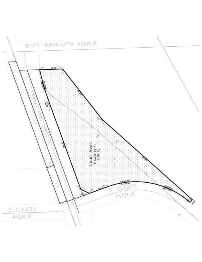
3700 S Duluth Ave
Sioux Falls, SD-MN
Uth Addn
64479
VAC GRANGE AVE LYING ADJ & TRACT 6B (EX LOTS E & F & EX LOTS H1 & H10) PARK SO UTH ADDN TO CITY OF SIOUX FALLS
Commercialacreage
Minnehaha
X
South Dakota
46099C0463E
e&f
2024
1.49 AC
2024
Sioux Falls
001501
Other Market Areas
DEMOGRAPHICS near 3700 S Duluth Ave
1 Mile
3 Mile
5 Mile
2024 Total Population
7,616
94,503
193,925
2029 Population
8,284
106,102
216,310
Pop Growth 2024-2029
+ 8.77%
+ 12.27%
+ 11.54%
Average Age
40
40
38
2024 Total Households
3,172
41,146
79,355
HH Growth 2024-2029
+ 9.08%
+ 12.55%
+ 11.96%
Median Household Inc
$73,217
$70,171
$72,338
Avg Household Size
2.20
2.20
2.30
2024 Avg HH Vehicles
2.00
2.00
2.00
Median Home Value
$269,620
$258,389
$253,598
Median Year Built
1970
1982
1992
Nearby Places
Map Layers
Map Styles
 Street
 Aerial
- Restaurants
- Banks
- Shops
- Fitness
- Groceries
PUBLIC TRANSPORTATION
AIRPORT
Joe Foss Field
DRIVE
WALK
Distance
Joe Foss Field
26 min
6.7 mi
SALE & LEASE HISTORY
LISTING DATE
SALE/LEASE

Sep 24, 2016
For Sale
Nearby Properties
Address
Land Use
TOTAL SIZE
Lot Size
Zoning
Address
Land Use
TOTAL SIZE
Lot Size
Zoning
14.81 AC
MUNICIPALI
Address
Land Use
TOTAL SIZE
Lot Size
Zoning
80,415 SF
13.13 AC
Address
Land Use
TOTAL SIZE
Lot Size
Zoning
8.89 AC
MUNICIPALI
Address
Land Use
TOTAL SIZE
Lot Size
Zoning
639,393 SF
53.46 AC
FP;FP
Address
Land Use
TOTAL SIZE
Lot Size
Zoning
8.90 AC
C1;NEIGHBO
Address
Land Use
TOTAL SIZE
Lot Size
Zoning
Address
Land Use
TOTAL SIZE
Lot Size
Zoning
8.80 AC
MUNICIPALI
Address
Land Use
TOTAL SIZE
Lot Size
Zoning
184,821 SF
1.83 AC
NO;SPECIAL
Address
Land Use
TOTAL SIZE
Lot Size
Zoning
7,252 SF
12.07 AC
Address
Land Use
TOTAL SIZE
Lot Size
Zoning
9.41 AC
Address
Land Use
TOTAL SIZE
Lot Size
Zoning
15.24 AC
MUNICIPALI
Address
Land Use
TOTAL SIZE
Lot Size
Zoning
360,262 SF
26 AC
Address
Land Use
TOTAL SIZE
Lot Size
Zoning
3.07 AC
FP;FP
Address
Land Use
TOTAL SIZE
Lot Size
Zoning
1.57 AC
C2;GENERAL
Address
Land Use
TOTAL SIZE
Lot Size
Zoning
51,004 SF
3.99 AC
Address
Land Use
TOTAL SIZE
Lot Size
Zoning
72,553 SF
0.97 AC
Address
Land Use
TOTAL SIZE
Lot Size
Zoning
9.42 AC
MUNICIPALI
Address
Land Use
TOTAL SIZE
Lot Size
Zoning
8.51 AC
MUNICIPALI
Address
Land Use
TOTAL SIZE
Lot Size
Zoning
1.20 AC
FP;FP
Address
Land Use
TOTAL SIZE
Lot Size
Zoning
15.40 AC
MUNICIPALI
Address
Land Use
TOTAL SIZE
Lot Size
Zoning
10.75 AC
MUNICIPALI
Address
Land Use
TOTAL SIZE
Lot Size
Zoning
9.45 AC
MUNICIPALI
Address
Land Use
TOTAL SIZE
Lot Size
Zoning
15.89 AC
Address
Land Use
TOTAL SIZE
Lot Size
Zoning
3,254 SF
2.13 AC
Address
Land Use
TOTAL SIZE
Lot Size
Zoning
99,834 SF
6.58 AC
Address
Land Use
TOTAL SIZE
Lot Size
Zoning
11.91 AC
MUNICIPALI
Address
Land Use
TOTAL SIZE
Lot Size
Zoning
8.57 AC
MUNICIPALI
Address
Land Use
TOTAL SIZE
Lot Size
Zoning
18.88 AC
MUNICIPALI
Address
Land Use
TOTAL SIZE
Lot Size
Zoning
7.91 AC
MUNICIPALI
Address
Land Use
TOTAL SIZE
Lot Size
Zoning
11.13 AC
MUNICIPALI
The World's #1 Commercial Real Estate Marketplace
Connect with us
© 2026 CoStar Group
The information above has been obtained from sources believed reliable. While we do not doubt its accuracy we have not verified it and make no guarantee, warranty or representation about it. It is your responsibility to independently confirm its accuracy and completeness. Any projections, opinions, assumptions, or estimates used are for example only and do not represent the current or future performance of the property. The value of this transaction to you depends on tax and other factors which should be evaluated by your tax, financial, and legal advisors. You and your advisors should conduct a careful, independent investigation of the property to determine to your satisfaction the suitability of the property for your needs.