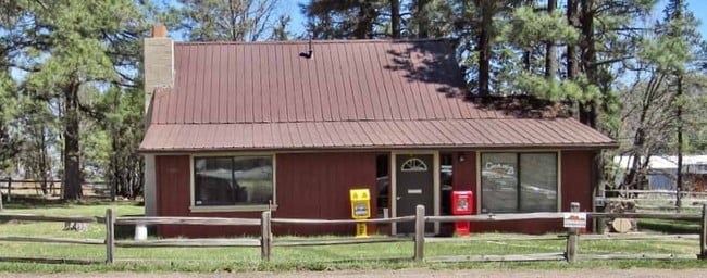
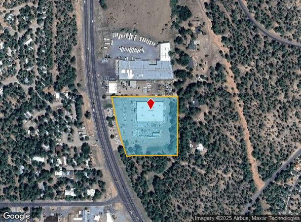
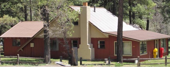
Property Record
3801 S White Mountain Rd, Show Low, AZ 85901
NEARBY LISTINGS FOR SALE OR LEASE
Property Detail
3801 S White Mountain Rd
210-33-019A
SECTION 32,T10N,R22E:BEG SE COR;TH S89DG38W 331; TH N0DG29E 31 5.6;TH S89DG37W 278.5TPOB; TH S89DG37W 328 TO R/W HWY 173;TH NWLY ALG R/W 400; TH N89DG37E 110;TH S13DG16E 197; TH N89DG 37E 218;TH S13DG16E 200TPOB LESS HWY R/W...ALSO: SECTION 32,T 10N,
Storemultistory
Navajo
X
Arizona
04017C4709F
3.74 AC
2024
Arizona Northeast & Holbrook Area
2026
Other Market Areas
961701
Show Low, AZ
22,705 SF
DEMOGRAPHICS near 3801 S White Mountain Rd
1 Mile
3 Mile
5 Mile
2024 Total Population
2,483
12,460
23,789
2029 Population
2,739
13,569
25,930
Pop Growth 2024-2029
+ 10.31%
+ 8.90%
+ 9.00%
Average Age
45
43
44
2024 Total Households
1,021
5,076
9,637
HH Growth 2024-2029
+ 10.09%
+ 8.83%
+ 8.98%
Median Household Inc
$58,738
$55,326
$55,640
Avg Household Size
2.40
2.40
2.40
2024 Avg HH Vehicles
2.00
2.00
2.00
Median Home Value
$267,187
$229,664
$230,764
Median Year Built
2001
1997
1996
Nearby Places
Map Layers
Map Styles
 Street
 Aerial
- Restaurants
- Banks
- Shops
- Fitness
- Groceries
Nearby Properties
Address
Land Use
TOTAL SIZE
Lot Size
Zoning
Address
Land Use
TOTAL SIZE
Lot Size
Zoning
147,745 SF
12.70 AC
MUNICIPAL
Address
Land Use
TOTAL SIZE
Lot Size
Zoning
203,623 SF
14 AC
MUNICIPAL
Address
Land Use
TOTAL SIZE
Lot Size
Zoning
138,315 SF
13.91 AC
MUNICIPAL
Address
Land Use
TOTAL SIZE
Lot Size
Zoning
81,647 SF
4.47 AC
MUNICIPAL
Address
Land Use
TOTAL SIZE
Lot Size
Zoning
55,688 SF
1.50 AC
C-R
Address
Land Use
TOTAL SIZE
Lot Size
Zoning
74,338 SF
2.29 AC
Address
Land Use
TOTAL SIZE
Lot Size
Zoning
83,087 SF
5.08 AC
MUNICIPAL
Address
Land Use
TOTAL SIZE
Lot Size
Zoning
56,096 SF
1.48 AC
C-R
Address
Land Use
TOTAL SIZE
Lot Size
Zoning
56,331 SF
16.30 AC
MUNICIPAL
Address
Land Use
TOTAL SIZE
Lot Size
Zoning
56,032 SF
4.60 AC
MUNICIPAL
Address
Land Use
TOTAL SIZE
Lot Size
Zoning
97,790 SF
4.80 AC
MUNICIPAL
Address
Land Use
TOTAL SIZE
Lot Size
Zoning
55,237 SF
6.03 AC
MUNICIPAL
Address
Land Use
TOTAL SIZE
Lot Size
Zoning
86,443 SF
6.85 AC
MUNICIPAL
Address
Land Use
TOTAL SIZE
Lot Size
Zoning
89,607 SF
5.78 AC
Address
Land Use
TOTAL SIZE
Lot Size
Zoning
29,707 SF
3 AC
MUNICIPAL
Address
Land Use
TOTAL SIZE
Lot Size
Zoning
32,762 SF
1.95 AC
MUNICIPAL
Address
Land Use
TOTAL SIZE
Lot Size
Zoning
30,942 SF
3.21 AC
MUNICIPAL
Address
Land Use
TOTAL SIZE
Lot Size
Zoning
46,700 SF
2.51 AC
MUNICIPAL
Address
Land Use
TOTAL SIZE
Lot Size
Zoning
33,421 SF
5.84 AC
MUNICIPAL
Address
Land Use
TOTAL SIZE
Lot Size
Zoning
22,680 SF
1.65 AC
C-R
Address
Land Use
TOTAL SIZE
Lot Size
Zoning
47,586 SF
3.50 AC
MUNICIPAL
Address
Land Use
TOTAL SIZE
Lot Size
Zoning
76,060 SF
4.69 AC
MUNICIPAL
Address
Land Use
TOTAL SIZE
Lot Size
Zoning
62,331 SF
4.20 AC
MUNICIPAL
Address
Land Use
TOTAL SIZE
Lot Size
Zoning
22,400 SF
2.55 AC
MUNICIPAL
Address
Land Use
TOTAL SIZE
Lot Size
Zoning
35,090 SF
3.40 AC
MUNICIPAL
Address
Land Use
TOTAL SIZE
Lot Size
Zoning
26,513 SF
9.76 AC
MUNICIPAL
Address
Land Use
TOTAL SIZE
Lot Size
Zoning
89,607 SF
3.97 AC
Address
Land Use
TOTAL SIZE
Lot Size
Zoning
21,291 SF
1.80 AC
MUNICIPAL
Address
Land Use
TOTAL SIZE
Lot Size
Zoning
18,000 SF
2.09 AC
MUNICIPAL
The World's #1 Commercial Real Estate Marketplace
Connect with us
© 2026 CoStar Group
The information above has been obtained from sources believed reliable. While we do not doubt its accuracy we have not verified it and make no guarantee, warranty or representation about it. It is your responsibility to independently confirm its accuracy and completeness. Any projections, opinions, assumptions, or estimates used are for example only and do not represent the current or future performance of the property. The value of this transaction to you depends on tax and other factors which should be evaluated by your tax, financial, and legal advisors. You and your advisors should conduct a careful, independent investigation of the property to determine to your satisfaction the suitability of the property for your needs.