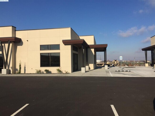
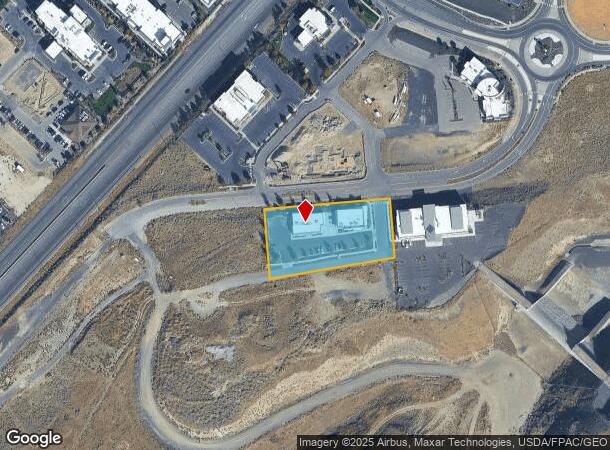
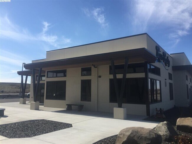
Property Record
3801 S Zintel Way, Kennewick, WA 99337
NEARBY LISTINGS FOR SALE OR LEASE
Property Detail
3801 S Zintel Way
Other Market Areas
Plat Alteration Of Boulder Ridge
Kennewick-Richland, WA
SECTION 16, TOWNSHIP 8 NORTH, RANGE 29 EAST, QTR SE: PLAT SUBDIVISION: PLAT ALTERATION OF BOULDER RIDGE, LOT 2. (AF#2014-028131, 11/05/2014).
116894050000002
Benton
Storebuilding
Washington
2024
2
2024
1.37 AC
011506
Yakima/Kennewick
6,821 SF
DEMOGRAPHICS near 3801 S Zintel Way
1 mile
3 mile
5 mile
2024 Total Population
5,057
56,659
111,473
2029 Population
5,528
60,921
120,001
Pop Growth 2024-2029
+ 9.31%
+ 7.52%
+ 7.65%
Average Age
41
37
38
2024 Total Households
1,948
20,789
41,004
HH Growth 2024-2029
+ 9.39%
+ 7.60%
+ 7.68%
Median Household Inc
$93,420
$68,602
$70,338
Avg Household Size
2.60
2.70
2.70
2024 Avg HH Vehicles
2.00
2.00
2.00
Median Home Value
$440,020
$336,046
$332,274
Median Year Built
2004
1984
1982
Nearby Places
Map Layers
Map Styles
 Street
 Aerial
Transit
 Traffic
 Biking
Places
Listings with unknown addresses are not visible on the map
- Restaurants
- Banks
- Shops
- Fitness
- Groceries
PUBLIC TRANSPORTATION
COMMUTER RAIL
Drive
Walk
Distance
15 min
8.1 mi
AIRPORT
Tri-Cities
Drive
Walk
Distance
Tri-Cities
15 min
8.1 mi
SALE & LEASE HISTORY
LISTING DATE
SALE/LEASE

Jul 13, 2023
For Lease
Apr 17, 2017
For Lease
Nearby Properties
Address
Land Use
TOTAL SIZE
Lot Size
Zoning
Address
Land Use
TOTAL SIZE
Lot Size
Zoning
192,199 SF
Address
Land Use
TOTAL SIZE
Lot Size
Zoning
190,434 SF
47.42 AC
Address
Land Use
TOTAL SIZE
Lot Size
Zoning
232,463 SF
31.54 AC
Address
Land Use
TOTAL SIZE
Lot Size
Zoning
141,940 SF
7.49 AC
Address
Land Use
TOTAL SIZE
Lot Size
Zoning
377,541 SF
24.58 AC
Address
Land Use
TOTAL SIZE
Lot Size
Zoning
138,421 SF
31.09 AC
Address
Land Use
TOTAL SIZE
Lot Size
Zoning
148,301 SF
6.41 AC
Address
Land Use
TOTAL SIZE
Lot Size
Zoning
224,114 SF
13.37 AC
Address
Land Use
TOTAL SIZE
Lot Size
Zoning
248,623 SF
12 AC
Address
Land Use
TOTAL SIZE
Lot Size
Zoning
159,807 SF
Address
Land Use
TOTAL SIZE
Lot Size
Zoning
179,139 SF
11.79 AC
Address
Land Use
TOTAL SIZE
Lot Size
Zoning
126,589 SF
4.05 AC
Address
Land Use
TOTAL SIZE
Lot Size
Zoning
74,556 SF
1.22 AC
Address
Land Use
TOTAL SIZE
Lot Size
Zoning
213,921 SF
22.78 AC
Address
Land Use
TOTAL SIZE
Lot Size
Zoning
52,900 SF
10.23 AC
Address
Land Use
TOTAL SIZE
Lot Size
Zoning
127,840 SF
3.69 AC
Address
Land Use
TOTAL SIZE
Lot Size
Zoning
172,573 SF
15.30 AC
Address
Land Use
TOTAL SIZE
Lot Size
Zoning
66,035 SF
15.38 AC
Address
Land Use
TOTAL SIZE
Lot Size
Zoning
61,400 SF
11.50 AC
Address
Land Use
TOTAL SIZE
Lot Size
Zoning
164,172 SF
9.37 AC
35
Address
Land Use
TOTAL SIZE
Lot Size
Zoning
132,060 SF
6.74 AC
35
Address
Land Use
TOTAL SIZE
Lot Size
Zoning
55,841 SF
12.30 AC
Address
Land Use
TOTAL SIZE
Lot Size
Zoning
86,190 SF
30.10 AC
Address
Land Use
TOTAL SIZE
Lot Size
Zoning
149,281 SF
10.79 AC
Address
Land Use
TOTAL SIZE
Lot Size
Zoning
67,748 SF
3.87 AC
Address
Land Use
TOTAL SIZE
Lot Size
Zoning
55,809 SF
10.79 AC
Address
Land Use
TOTAL SIZE
Lot Size
Zoning
103,115 SF
8.38 AC
Address
Land Use
TOTAL SIZE
Lot Size
Zoning
47.42 AC
Address
Land Use
TOTAL SIZE
Lot Size
Zoning
118,219 SF
6.61 AC
35
Address
Land Use
TOTAL SIZE
Lot Size
Zoning
57,794 SF
14.38 AC
The World's #1 Commercial Real Estate Marketplace
Connect with us
© 2026 CoStar Group
The information above has been obtained from sources believed reliable. While we do not doubt its accuracy we have not verified it and make no guarantee, warranty or representation about it. It is your responsibility to independently confirm its accuracy and completeness. Any projections, opinions, assumptions, or estimates used are for example only and do not represent the current or future performance of the property. The value of this transaction to you depends on tax and other factors which should be evaluated by your tax, financial, and legal advisors. You and your advisors should conduct a careful, independent investigation of the property to determine to your satisfaction the suitability of the property for your needs.