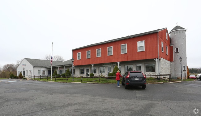
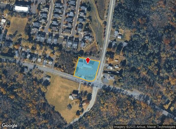
Property Record
3801 Skippack Pike, Skippack, PA 19474

Current Lease Availabilities
NEARBY LISTINGS FOR SALE OR LEASE
Property Detail
3801 Skippack Pike
Philadelphia-Camden-Wilmington, PA-NJ-DE-MD
Plan & Prepared Mary Ziegler S
51-00-03301-005
ASSESSOR BLOCK-UNIT NUMBER 8-60
Commercialnec
Montgomery
X
Pennsylvania
42091C0232G
60
2024
1.50 AC
2025
West Montgomery County
206704
Philadelphia
11,504 SF
DEMOGRAPHICS near 3801 Skippack Pike
1 Mile
3 Mile
5 Mile
2024 Total Population
3,051
23,073
100,040
2029 Population
2,973
23,132
101,284
Pop Growth 2024-2029
(2.56%)
+ 0.26%
+ 1.24%
Average Age
42
43
43
2024 Total Households
1,140
8,005
35,372
HH Growth 2024-2029
(2.63%)
+ 0.27%
+ 1.26%
Median Household Inc
$141,037
$148,205
$123,273
Avg Household Size
2.70
2.70
2.60
2024 Avg HH Vehicles
2.00
2.00
2.00
Median Home Value
$437,831
$446,885
$421,802
Median Year Built
1990
1990
1985
Nearby Places
Map Layers
Map Styles
 Street
 Aerial
- Restaurants
- Banks
- Shops
- Fitness
- Groceries
PUBLIC TRANSPORTATION
COMMUTER RAIL
Pennbrook (R5 - Southeastern Pennsylvania Transportation Authority Regional Rail (SEPTA Regional Rail))
DRIVE
WALK
Distance
Pennbrook (R5 - Southeastern Pennsylvania Transportation Authority Regional Rail (SEPTA Regional Rail))
14 min
7.9 mi
Lansdale (R5 - Southeastern Pennsylvania Transportation Authority Regional Rail (SEPTA Regional Rail))
DRIVE
WALK
Distance
Lansdale (R5 - Southeastern Pennsylvania Transportation Authority Regional Rail (SEPTA Regional Rail))
14 min
8.0 mi
AIRPORT
Philadelphia International
DRIVE
WALK
Distance
Philadelphia International
54 min
38.0 mi
Lehigh Valley International
DRIVE
WALK
Distance
Lehigh Valley International
55 min
41.4 mi
Freight Ports
Port of Philadelphia
DRIVE
WALK
Distance
Port of Philadelphia
42 min
25.2 mi
Nearby Properties
Address
Land Use
TOTAL SIZE
Lot Size
Zoning
Address
Land Use
TOTAL SIZE
Lot Size
Zoning
720,767 SF
118.21 AC
AGR
Address
Land Use
TOTAL SIZE
Lot Size
Zoning
98,724 SF
35.50 AC
R1
Address
Land Use
TOTAL SIZE
Lot Size
Zoning
68,442 SF
12.22 AC
AGR
Address
Land Use
TOTAL SIZE
Lot Size
Zoning
90,217 SF
19 AC
R1
Address
Land Use
TOTAL SIZE
Lot Size
Zoning
77,700 SF
1.78 AC
BC
Address
Land Use
TOTAL SIZE
Lot Size
Zoning
29,014 SF
13.41 AC
R5
Address
Land Use
TOTAL SIZE
Lot Size
Zoning
59,965 SF
14.20 AC
R175
Address
Land Use
TOTAL SIZE
Lot Size
Zoning
113,781 SF
8.62 AC
LI
Address
Land Use
TOTAL SIZE
Lot Size
Zoning
223.97 AC
R1
Address
Land Use
TOTAL SIZE
Lot Size
Zoning
102,520 SF
2.21 AC
C
Address
Land Use
TOTAL SIZE
Lot Size
Zoning
111,474 SF
4.47 AC
C
Address
Land Use
TOTAL SIZE
Lot Size
Zoning
9,632 SF
7.76 AC
C
Address
Land Use
TOTAL SIZE
Lot Size
Zoning
53,032 SF
1.26 AC
BC
Address
Land Use
TOTAL SIZE
Lot Size
Zoning
28,885 SF
52.82 AC
CF-2
Address
Land Use
TOTAL SIZE
Lot Size
Zoning
48,360 SF
8.65 AC
LI
Address
Land Use
TOTAL SIZE
Lot Size
Zoning
54,704 SF
6.69 AC
LI
Address
Land Use
TOTAL SIZE
Lot Size
Zoning
24,408 SF
20.74 AC
R1
Address
Land Use
TOTAL SIZE
Lot Size
Zoning
87,190 SF
14.47 AC
LI
Address
Land Use
TOTAL SIZE
Lot Size
Zoning
6,569 SF
107 AC
IR
Address
Land Use
TOTAL SIZE
Lot Size
Zoning
70,524 SF
10.66 AC
LI
Address
Land Use
TOTAL SIZE
Lot Size
Zoning
32,000 SF
15.65 AC
C
Address
Land Use
TOTAL SIZE
Lot Size
Zoning
20,730 SF
36.85 AC
AGR
Address
Land Use
TOTAL SIZE
Lot Size
Zoning
23,234 SF
0.34 AC
VC
Address
Land Use
TOTAL SIZE
Lot Size
Zoning
55,586 SF
4.50 AC
LI
Address
Land Use
TOTAL SIZE
Lot Size
Zoning
35,207 SF
12.40 AC
AGR
Address
Land Use
TOTAL SIZE
Lot Size
Zoning
23,125 SF
3.31 AC
GC
Address
Land Use
TOTAL SIZE
Lot Size
Zoning
27,316 SF
28.61 AC
LI
Address
Land Use
TOTAL SIZE
Lot Size
Zoning
58,139 SF
6.01 AC
LI
Address
Land Use
TOTAL SIZE
Lot Size
Zoning
15,140 SF
1.92 AC
GC
Address
Land Use
TOTAL SIZE
Lot Size
Zoning
35,835 SF
9.20 AC
GC
The World's #1 Commercial Real Estate Marketplace
Connect with us
© 2026 CoStar Group
The information above has been obtained from sources believed reliable. While we do not doubt its accuracy we have not verified it and make no guarantee, warranty or representation about it. It is your responsibility to independently confirm its accuracy and completeness. Any projections, opinions, assumptions, or estimates used are for example only and do not represent the current or future performance of the property. The value of this transaction to you depends on tax and other factors which should be evaluated by your tax, financial, and legal advisors. You and your advisors should conduct a careful, independent investigation of the property to determine to your satisfaction the suitability of the property for your needs.