Property Record
3801 W 2Nd St, Owensboro, KY 42301
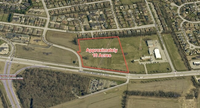

This Property Is For Sale
NEARBY LISTINGS FOR SALE OR LEASE
Property Detail
3801 W 2Nd St
046-00-00-054-00-000
46-543801 W 2ND ST24.609 ACRES
Commercialnec
Daviess
AE
Kentucky
21059C0118E
24.07 AC
2025
Kentucky West Area
2025
Other Market Areas
001300
Owensboro, KY
12,500 SF
DEMOGRAPHICS near 3801 W 2Nd St
1 Mile
3 Mile
5 Mile
2024 Total Population
4,814
31,243
62,266
2029 Population
4,742
31,281
62,415
Pop Growth 2024-2029
(1.50%)
+ 0.12%
+ 0.24%
Average Age
39
40
40
2024 Total Households
1,917
12,861
25,848
HH Growth 2024-2029
(1.56%)
+ 0.17%
+ 0.27%
Median Household Inc
$47,212
$52,842
$51,448
Avg Household Size
2.40
2.30
2.30
2024 Avg HH Vehicles
2.00
2.00
2.00
Median Home Value
$122,079
$148,495
$146,472
Median Year Built
1977
1969
1971
Nearby Places
Map Layers
Map Styles
 Street
 Aerial
- Restaurants
- Banks
- Shops
- Fitness
- Groceries
PUBLIC TRANSPORTATION
AIRPORT
Evansville Regional
DRIVE
WALK
Distance
Evansville Regional
54 min
38.8 mi
Freight Ports
Port of Toledo
DRIVE
WALK
Distance
Port of Toledo
476 min
413.3 mi
Nearby Properties
Address
Land Use
TOTAL SIZE
Lot Size
Zoning
Address
Land Use
TOTAL SIZE
Lot Size
Zoning
169,482 SF
10.21 AC
Address
Land Use
TOTAL SIZE
Lot Size
Zoning
3,610 SF
1.23 AC
Address
Land Use
TOTAL SIZE
Lot Size
Zoning
184,854 SF
9.46 AC
Address
Land Use
TOTAL SIZE
Lot Size
Zoning
88,745 SF
2.62 AC
Address
Land Use
TOTAL SIZE
Lot Size
Zoning
454,200 SF
44.55 AC
Address
Land Use
TOTAL SIZE
Lot Size
Zoning
424,078 SF
43.02 AC
Address
Land Use
TOTAL SIZE
Lot Size
Zoning
46,184 SF
1.99 AC
Address
Land Use
TOTAL SIZE
Lot Size
Zoning
113,025 SF
2.10 AC
Address
Land Use
TOTAL SIZE
Lot Size
Zoning
62,312 SF
0.88 AC
Address
Land Use
TOTAL SIZE
Lot Size
Zoning
215,439 SF
15.02 AC
Address
Land Use
TOTAL SIZE
Lot Size
Zoning
82,027 SF
2.40 AC
Address
Land Use
TOTAL SIZE
Lot Size
Zoning
180 SF
122.13 AC
Address
Land Use
TOTAL SIZE
Lot Size
Zoning
53,280 SF
Address
Land Use
TOTAL SIZE
Lot Size
Zoning
326,232 SF
29.64 AC
Address
Land Use
TOTAL SIZE
Lot Size
Zoning
54,713 SF
20 AC
Address
Land Use
TOTAL SIZE
Lot Size
Zoning
280 SF
2.60 AC
Address
Land Use
TOTAL SIZE
Lot Size
Zoning
45,860 SF
13.88 AC
Address
Land Use
TOTAL SIZE
Lot Size
Zoning
69,884 SF
61.31 AC
Address
Land Use
TOTAL SIZE
Lot Size
Zoning
340,000 SF
33.62 AC
Address
Land Use
TOTAL SIZE
Lot Size
Zoning
155,700 SF
7.78 AC
Address
Land Use
TOTAL SIZE
Lot Size
Zoning
82,396 SF
28.50 AC
Address
Land Use
TOTAL SIZE
Lot Size
Zoning
51,232 SF
1.40 AC
Address
Land Use
TOTAL SIZE
Lot Size
Zoning
1,980 SF
303.90 AC
Address
Land Use
TOTAL SIZE
Lot Size
Zoning
4.35 AC
Address
Land Use
TOTAL SIZE
Lot Size
Zoning
92,159 SF
2.08 AC
Address
Land Use
TOTAL SIZE
Lot Size
Zoning
58,060 SF
2.07 AC
Address
Land Use
TOTAL SIZE
Lot Size
Zoning
17,289 SF
810.94 AC
Address
Land Use
TOTAL SIZE
Lot Size
Zoning
109,630 SF
1.02 AC
Address
Land Use
TOTAL SIZE
Lot Size
Zoning
4,160 SF
1.26 AC
Address
Land Use
TOTAL SIZE
Lot Size
Zoning
44,887 SF
4.31 AC
The World's #1 Commercial Real Estate Marketplace
Connect with us
© 2026 CoStar Group
The information above has been obtained from sources believed reliable. While we do not doubt its accuracy we have not verified it and make no guarantee, warranty or representation about it. It is your responsibility to independently confirm its accuracy and completeness. Any projections, opinions, assumptions, or estimates used are for example only and do not represent the current or future performance of the property. The value of this transaction to you depends on tax and other factors which should be evaluated by your tax, financial, and legal advisors. You and your advisors should conduct a careful, independent investigation of the property to determine to your satisfaction the suitability of the property for your needs.