Property Record
38011 Pretty Pond Rd, Zephyrhills, FL 33540
NEARBY LISTINGS FOR SALE OR LEASE
-
-
View all Zephyrhills listings for sale on LoopNet.com
Property Detail
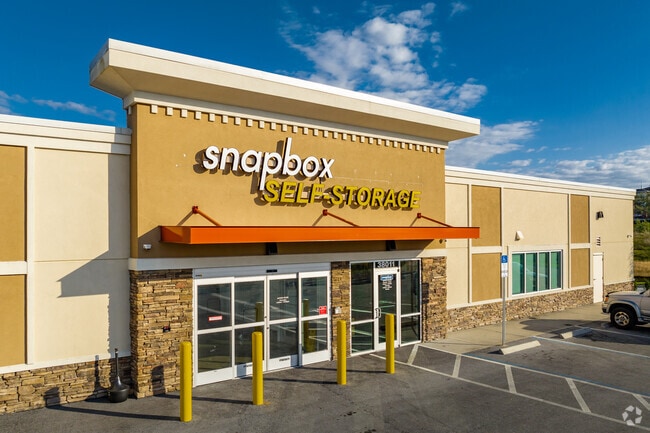
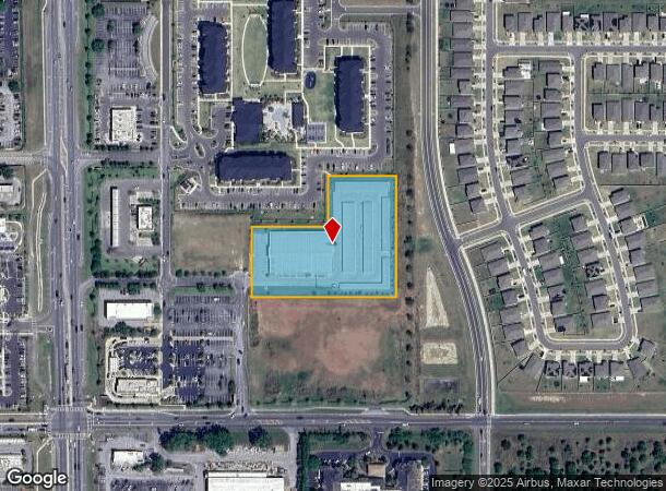
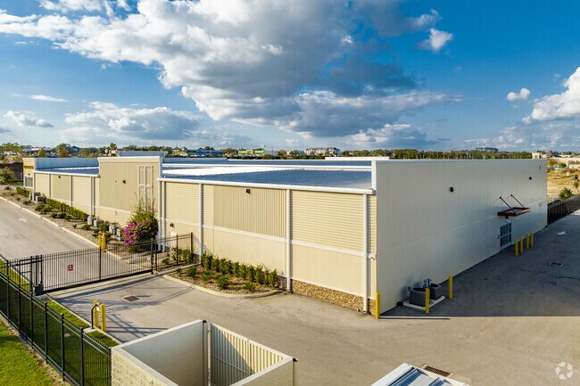
38011 Pretty Pond Rd
Tampa-St. Petersburg-Clearwater, FL
Zephyrhills Colony Company Lands
35-25-21-0010-00700-0010
ZEPHYRHILLS COLONY COMPANY LANDS PB 1 PG 55 PORTION OF TRACTS 41, 42, 55, 56 COM AT NW COR OF SEC 35 TH S89DEG5850E 1015.17 FT TH S00DEG0846W 2598.61 FT TH N89DEG5448W 54.91 FT TH N00DEG0846E 352.28 FT TO POB TH S89DEG5848W FOR 457.92 FT TH N00DEG011
Warehouse
Pasco
X
Florida
12101C0289F
1
2024
3.13 AC
2025
Pasco County
032805
Tampa/St Petersburg
79,605 SF
DEMOGRAPHICS near 38011 Pretty Pond Rd
1 Mile
3 Mile
5 Mile
2024 Total Population
7,678
40,110
73,988
2029 Population
9,361
48,641
90,018
Pop Growth 2024-2029
+ 21.92%
+ 21.27%
+ 21.67%
Average Age
50
49
49
2024 Total Households
3,566
18,373
33,284
HH Growth 2024-2029
+ 21.82%
+ 21.31%
+ 21.67%
Median Household Inc
$42,806
$42,756
$45,921
Avg Household Size
2.10
2.10
2.20
2024 Avg HH Vehicles
2.00
2.00
2.00
Median Home Value
$148,631
$130,355
$126,978
Median Year Built
1993
1984
1987
Nearby Places
- Restaurants
- Banks
- Shops
- Fitness
- Groceries
PUBLIC TRANSPORTATION
AIRPORT
Tampa International
DRIVE
WALK
Distance
Tampa International
58 min
38.7 mi
Freight Ports
Port of Tampa Bay
DRIVE
WALK
Distance
Port of Tampa Bay
51 min
32.1 mi
Nearby Properties
Address
Land Use
TOTAL SIZE
Lot Size
Zoning
Address
Land Use
TOTAL SIZE
Lot Size
Zoning
273,092 SF
12.29 AC
R4
Address
Land Use
TOTAL SIZE
Lot Size
Zoning
352,321 SF
27.88 AC
OP
Address
Land Use
TOTAL SIZE
Lot Size
Zoning
199,367 SF
15.46 AC
R2
Address
Land Use
TOTAL SIZE
Lot Size
Zoning
127,340 SF
15.04 AC
AC
Address
Land Use
TOTAL SIZE
Lot Size
Zoning
162,278 SF
118.82 AC
AP2
Address
Land Use
TOTAL SIZE
Lot Size
Zoning
107,232 SF
12.79 AC
MPUD
Address
Land Use
TOTAL SIZE
Lot Size
Zoning
292,589 SF
52.57 AC
R3
Address
Land Use
TOTAL SIZE
Lot Size
Zoning
88,782 SF
4.09 AC
M1
Address
Land Use
TOTAL SIZE
Lot Size
Zoning
91,192 SF
3.40 AC
C2
Address
Land Use
TOTAL SIZE
Lot Size
Zoning
98,980 SF
5.36 AC
C2
Address
Land Use
TOTAL SIZE
Lot Size
Zoning
216,202 SF
23.77 AC
C2
Address
Land Use
TOTAL SIZE
Lot Size
Zoning
68,446 SF
3.54 AC
C2
Address
Land Use
TOTAL SIZE
Lot Size
Zoning
105,449 SF
5.14 AC
OP
Address
Land Use
TOTAL SIZE
Lot Size
Zoning
101.06 AC
MPUD
Address
Land Use
TOTAL SIZE
Lot Size
Zoning
60,759 SF
7.56 AC
C2
Address
Land Use
TOTAL SIZE
Lot Size
Zoning
32,076 SF
3.58 AC
PUD
Address
Land Use
TOTAL SIZE
Lot Size
Zoning
107,022 SF
13.27 AC
C2
Address
Land Use
TOTAL SIZE
Lot Size
Zoning
56,312 SF
8.85 AC
PUD
Address
Land Use
TOTAL SIZE
Lot Size
Zoning
94,412 SF
9.67 AC
C2
Address
Land Use
TOTAL SIZE
Lot Size
Zoning
62,320 SF
8.13 AC
R4
Address
Land Use
TOTAL SIZE
Lot Size
Zoning
143,626 SF
11.13 AC
R4
Address
Land Use
TOTAL SIZE
Lot Size
Zoning
61,636 SF
6.84 AC
C2
Address
Land Use
TOTAL SIZE
Lot Size
Zoning
131,274 SF
13.07 AC
R4
Address
Land Use
TOTAL SIZE
Lot Size
Zoning
123,959 SF
15.18 AC
C2
Address
Land Use
TOTAL SIZE
Lot Size
Zoning
72,183 SF
42.44 AC
R3
Address
Land Use
TOTAL SIZE
Lot Size
Zoning
67,222 SF
7.96 AC
C2
Address
Land Use
TOTAL SIZE
Lot Size
Zoning
28,549 SF
1.49 AC
SD
Address
Land Use
TOTAL SIZE
Lot Size
Zoning
20,543 SF
4.18 AC
C2
Address
Land Use
TOTAL SIZE
Lot Size
Zoning
76,818 SF
15 AC
AC
The World's #1 Commercial Real Estate Marketplace
Connect with us
© 2025 CoStar Group
The information above has been obtained from sources believed reliable. While we do not doubt its accuracy we have not verified it and make no guarantee, warranty or representation about it. It is your responsibility to independently confirm its accuracy and completeness. Any projections, opinions, assumptions, or estimates used are for example only and do not represent the current or future performance of the property. The value of this transaction to you depends on tax and other factors which should be evaluated by your tax, financial, and legal advisors. You and your advisors should conduct a careful, independent investigation of the property to determine to your satisfaction the suitability of the property for your needs.