Property Record
3802 Annapolis Rd, Halethorpe, MD 21227
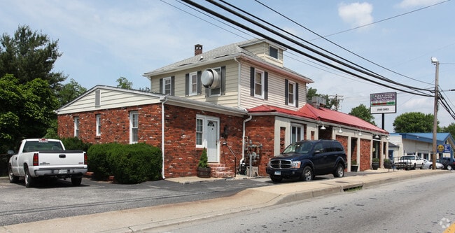

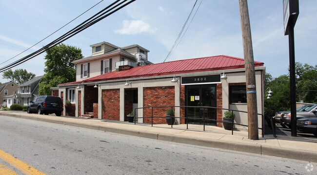
Property Detail
3802 Annapolis Rd
13-1312590330
WS ANNAPOLIS RD
Restaurantbuilding
Baltimore
BL
Maryland
B and X Area of moderate flood hazard, usually the area between the limits of the 100-year and 500-year floods.
1.10 AC
2024
BWI/Baltimore County
2025
Baltimore
430101
Baltimore-Columbia-Towson, MD
5,318 SF
NEARBY LISTINGS FOR SALE OR LEASE
DEMOGRAPHICS near 3802 Annapolis Rd
1 mile
3 mile
5 mile
2025 Total Population
20,528
113,307
357,707
2030 Population
20,258
113,349
358,299
Pop Growth 2025-2030
(1.32%)
+ 0.04%
+ 0.17%
Average Age
35
37
38
2025 Total Households
7,202
43,889
152,949
HH Growth 2025-2030
(1.33%)
(0.21%)
(0.06%)
Median Household Inc
$46,503
$68,576
$65,939
Avg Household Size
2.80
2.50
2.20
2025 Avg HH Vehicles
1.00
1.00
1.00
Median Home Value
$219,318
$272,178
$277,432
Median Year Built
1957
1952
1952
Nearby Places
Map Layers
Map Styles
 Street
 Aerial
Layers
 Traffic
 Biking
Places
Listings with unknown addresses are not visible on the map
- Restaurants
- Banks
- Shops
- Fitness
- Groceries
PUBLIC TRANSPORTATION
TRANSIT/SUBWAY
Patapsco (Hunt Valley & BWI Marshall - Maryland Transit Administration Light Rail (Baltimore Light Rail), Timonium & Cromwell - Maryland Transit Administration Light Rail (Baltimore Light Rail))
Drive
Walk
Distance
Patapsco (Hunt Valley & BWI Marshall - Maryland Transit Administration Light Rail (Baltimore Light Rail), Timonium & Cromwell - Maryland Transit Administration Light Rail (Baltimore Light Rail))
2 min
14 min
0.7 mi
Baltimore Highlands (Hunt Valley & BWI Marshall - Maryland Transit Administration Light Rail (Baltimore Light Rail), Timonium & Cromwell - Maryland Transit Administration Light Rail (Baltimore Light Rail))
Drive
Walk
Distance
Baltimore Highlands (Hunt Valley & BWI Marshall - Maryland Transit Administration Light Rail (Baltimore Light Rail), Timonium & Cromwell - Maryland Transit Administration Light Rail (Baltimore Light Rail))
3 min
17 min
0.9 mi
COMMUTER RAIL
Halethorpe Marc Nb (PENN - WASHINGTON - Maryland Transit Administration)
Drive
Walk
Distance
Halethorpe Marc Nb (PENN - WASHINGTON - Maryland Transit Administration)
10 min
4.1 mi
Halethorpe Marc Sb (PENN - WASHINGTON - Maryland Transit Administration)
Drive
Walk
Distance
Halethorpe Marc Sb (PENN - WASHINGTON - Maryland Transit Administration)
10 min
4.1 mi
AIRPORT
Baltimore/Washington International Thurgood Marshall
Drive
Walk
Distance
Baltimore/Washington International Thurgood Marshall
13 min
6.0 mi
Freight Ports
Port of Baltimore
Drive
Walk
Distance
Port of Baltimore
10 min
4.2 mi
Nearby Properties
Address
Land Use
TOTAL SIZE
Lot Size
Zoning
Address
Land Use
TOTAL SIZE
Lot Size
Zoning
20.26 AC
C-5DC
Address
Land Use
TOTAL SIZE
Lot Size
Zoning
308,887 SF
3.98 AC
C-5DC
Address
Land Use
TOTAL SIZE
Lot Size
Zoning
21.27 AC
C-5DC
Address
Land Use
TOTAL SIZE
Lot Size
Zoning
1,396,807 SF
32.73 AC
R-6
Address
Land Use
TOTAL SIZE
Lot Size
Zoning
642,817 SF
1.91 AC
PC-2
Address
Land Use
TOTAL SIZE
Lot Size
Zoning
520,407 SF
16.85 AC
H
Address
Land Use
TOTAL SIZE
Lot Size
Zoning
522,990 SF
2.31 AC
TOD-4
Address
Land Use
TOTAL SIZE
Lot Size
Zoning
309,558 SF
3.01 AC
C-2
Address
Land Use
TOTAL SIZE
Lot Size
Zoning
528,399 SF
0.21 AC
TOD-4
Address
Land Use
TOTAL SIZE
Lot Size
Zoning
315,605 SF
1.80 AC
Address
Land Use
TOTAL SIZE
Lot Size
Zoning
442,145 SF
2.30 AC
C-2
Address
Land Use
TOTAL SIZE
Lot Size
Zoning
523,800 SF
28.02 AC
I-1
Address
Land Use
TOTAL SIZE
Lot Size
Zoning
321,500 SF
26.79 AC
C-5DC
Address
Land Use
TOTAL SIZE
Lot Size
Zoning
277,887 SF
0.31 AC
OR-2
Address
Land Use
TOTAL SIZE
Lot Size
Zoning
1,105,167 SF
6.35 AC
C-5DC
Address
Land Use
TOTAL SIZE
Lot Size
Zoning
234,439 SF
1.02 AC
Address
Land Use
TOTAL SIZE
Lot Size
Zoning
290,000 SF
1.51 AC
PC-2
Address
Land Use
TOTAL SIZE
Lot Size
Zoning
315,055 SF
9.60 AC
ML
Address
Land Use
TOTAL SIZE
Lot Size
Zoning
1,308,804 SF
16.24 AC
I-MU
Address
Land Use
TOTAL SIZE
Lot Size
Zoning
132,655 SF
0.74 AC
Address
Land Use
TOTAL SIZE
Lot Size
Zoning
263,024 SF
6.87 AC
C3
Address
Land Use
TOTAL SIZE
Lot Size
Zoning
18.86 AC
DR16
Address
Land Use
TOTAL SIZE
Lot Size
Zoning
73,080 SF
6.34 AC
C-5DC
Address
Land Use
TOTAL SIZE
Lot Size
Zoning
184,317 SF
16.23 AC
MH
Address
Land Use
TOTAL SIZE
Lot Size
Zoning
173,735 SF
17.31 AC
PC-4
Address
Land Use
TOTAL SIZE
Lot Size
Zoning
41.14 AC
W1-BW
Address
Land Use
TOTAL SIZE
Lot Size
Zoning
297,984 SF
6.84 AC
R-8
Address
Land Use
TOTAL SIZE
Lot Size
Zoning
374,715 SF
2.96 AC
C-2
Address
Land Use
TOTAL SIZE
Lot Size
Zoning
300,513 SF
32.53 AC
I-1
Address
Land Use
TOTAL SIZE
Lot Size
Zoning
15.05 AC
R15
The World's #1 Commercial Real Estate Marketplace
Connect with us
© 2026 CoStar Group
The information above has been obtained from sources believed reliable. While we do not doubt its accuracy we have not verified it and make no guarantee, warranty or representation about it. It is your responsibility to independently confirm its accuracy and completeness. Any projections, opinions, assumptions, or estimates used are for example only and do not represent the current or future performance of the property. The value of this transaction to you depends on tax and other factors which should be evaluated by your tax, financial, and legal advisors. You and your advisors should conduct a careful, independent investigation of the property to determine to your satisfaction the suitability of the property for your needs.