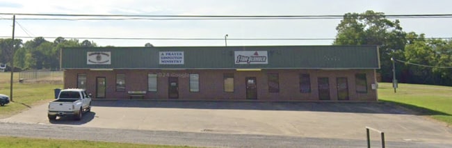
Property Record
3802 Al Highway 21 S, Oxford, AL 36203

Current Lease Availabilities
NEARBY LISTINGS FOR SALE OR LEASE
-
-
View all Oxford listings for lease on LoopNet.com
Property Detail
3802 Al Highway 21 S
06-01-01-0-000-017.000
5.44 AC(C) BEG @ NE COR TRACT 6 O W COOPER FARM S/D PB 2 PG 88 SEC 1 T17S R7E; TH SW ALG AL HWY 21 670' TH NE ALG GRAVEL RD
Storesoffices
Talladega
X
Alabama
01015C0403E
6
2025
4.45 AC
2024
Talladega County
010101
Birmingham
5,000 SF
Talladega-Sylacauga, AL
DEMOGRAPHICS near 3802 Al Highway 21 S
1 Mile
3 Mile
5 Mile
2024 Total Population
858
11,933
23,630
2029 Population
827
11,539
23,020
Pop Growth 2024-2029
(3.61%)
(3.30%)
(2.58%)
Average Age
41
41
41
2024 Total Households
327
4,526
9,324
HH Growth 2024-2029
(3.98%)
(3.56%)
(2.81%)
Median Household Inc
$87,500
$61,775
$56,070
Avg Household Size
2.60
2.50
2.40
2024 Avg HH Vehicles
3.00
2.00
2.00
Median Home Value
$171,373
$163,736
$156,680
Median Year Built
1991
1983
1981
Nearby Places
- Restaurants
- Banks
- Shops
- Fitness
- Groceries
PUBLIC TRANSPORTATION
COMMUTER RAIL
Anniston Amtrak Station (Crescent - Amtrak)
DRIVE
WALK
Distance
Anniston Amtrak Station (Crescent - Amtrak)
11 min
6.1 mi
Freight Ports
Port of Panama City
DRIVE
WALK
Distance
Port of Panama City
352 min
286.4 mi
Nearby Properties
Address
Land Use
TOTAL SIZE
Lot Size
Zoning
Address
Land Use
TOTAL SIZE
Lot Size
Zoning
128,399 SF
17 AC
Address
Land Use
TOTAL SIZE
Lot Size
Zoning
7,752 SF
182 AC
Address
Land Use
TOTAL SIZE
Lot Size
Zoning
1,972 SF
22.80 AC
Address
Land Use
TOTAL SIZE
Lot Size
Zoning
87,750 SF
25 AC
Address
Land Use
TOTAL SIZE
Lot Size
Zoning
201,670 SF
27.50 AC
Address
Land Use
TOTAL SIZE
Lot Size
Zoning
14,015 SF
8.50 AC
Address
Land Use
TOTAL SIZE
Lot Size
Zoning
12,695 SF
0.75 AC
Address
Land Use
TOTAL SIZE
Lot Size
Zoning
128,064 SF
7.70 AC
Address
Land Use
TOTAL SIZE
Lot Size
Zoning
3.50 AC
Address
Land Use
TOTAL SIZE
Lot Size
Zoning
15,080 SF
24 AC
Address
Land Use
TOTAL SIZE
Lot Size
Zoning
81,250 SF
18 AC
Address
Land Use
TOTAL SIZE
Lot Size
Zoning
171,881 SF
29 AC
Address
Land Use
TOTAL SIZE
Lot Size
Zoning
19,016 SF
4 AC
Address
Land Use
TOTAL SIZE
Lot Size
Zoning
81,920 SF
10 AC
Address
Land Use
TOTAL SIZE
Lot Size
Zoning
34,350 SF
2.60 AC
Address
Land Use
TOTAL SIZE
Lot Size
Zoning
20,446 SF
4.80 AC
Address
Land Use
TOTAL SIZE
Lot Size
Zoning
42,781 SF
3.30 AC
Address
Land Use
TOTAL SIZE
Lot Size
Zoning
17,500 SF
4 AC
Address
Land Use
TOTAL SIZE
Lot Size
Zoning
105,252 SF
7.60 AC
Address
Land Use
TOTAL SIZE
Lot Size
Zoning
18,834 SF
2.37 AC
Address
Land Use
TOTAL SIZE
Lot Size
Zoning
1.11 AC
Address
Land Use
TOTAL SIZE
Lot Size
Zoning
1.25 AC
Address
Land Use
TOTAL SIZE
Lot Size
Zoning
22,000 SF
8.60 AC
Address
Land Use
TOTAL SIZE
Lot Size
Zoning
27,500 SF
3.02 AC
Address
Land Use
TOTAL SIZE
Lot Size
Zoning
39,000 SF
2.20 AC
Address
Land Use
TOTAL SIZE
Lot Size
Zoning
2,958 SF
2 AC
Address
Land Use
TOTAL SIZE
Lot Size
Zoning
69,248 SF
5.90 AC
Address
Land Use
TOTAL SIZE
Lot Size
Zoning
33,070 SF
1.80 AC
Address
Land Use
TOTAL SIZE
Lot Size
Zoning
38,336 SF
2.08 AC
Address
Land Use
TOTAL SIZE
Lot Size
Zoning
2,577 SF
1.78 AC
The World's #1 Commercial Real Estate Marketplace
Connect with us
© 2025 CoStar Group
The information above has been obtained from sources believed reliable. While we do not doubt its accuracy we have not verified it and make no guarantee, warranty or representation about it. It is your responsibility to independently confirm its accuracy and completeness. Any projections, opinions, assumptions, or estimates used are for example only and do not represent the current or future performance of the property. The value of this transaction to you depends on tax and other factors which should be evaluated by your tax, financial, and legal advisors. You and your advisors should conduct a careful, independent investigation of the property to determine to your satisfaction the suitability of the property for your needs.