Property Record
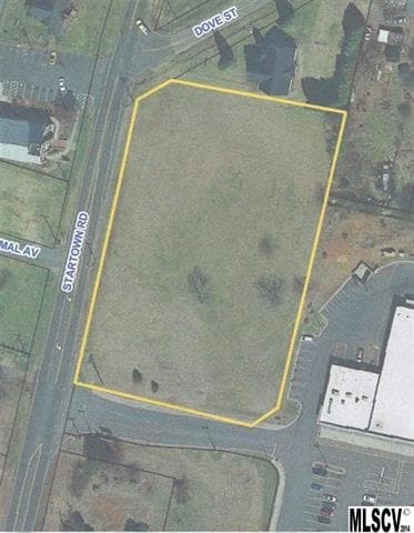
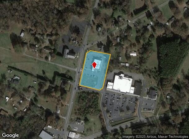
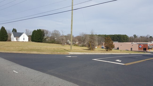
3802 Startown Rd, Newton, NC 28658
NEARBY LISTINGS FOR SALE OR LEASE
Property Detail
3802 Startown Rd
Hickory-Lenoir-Morganton, NC
Startown Crossing Shopping Center
3629076821290000
LOT 2 PLAT 57-145
Medicalbuilding
Catawba
X
North Carolina
3710362900J
2
2024
2.07 AC
2025
Catawba County
011701
Charlotte
7,369 SF
DEMOGRAPHICS near 3802 Startown Rd
1 Mile
3 Mile
5 Mile
2024 Total Population
2,180
11,665
32,655
2029 Population
2,264
12,190
34,141
Pop Growth 2024-2029
+ 3.85%
+ 4.50%
+ 4.55%
Average Age
43
42
41
2024 Total Households
818
4,656
12,785
HH Growth 2024-2029
+ 3.79%
+ 4.49%
+ 4.50%
Median Household Inc
$82,284
$72,113
$61,246
Avg Household Size
2.60
2.40
2.40
2024 Avg HH Vehicles
3.00
2.00
2.00
Median Home Value
$236,040
$188,260
$176,777
Median Year Built
1986
1978
1983
Nearby Places
Map Layers
Map Styles
 Street
 Aerial
- Restaurants
- Banks
- Shops
- Fitness
- Groceries
SALE & LEASE HISTORY
LISTING DATE
SALE/LEASE

Sep 24, 2016
For Sale
Sep 24, 2016
For Sale
Jan 18, 2017
For Sale
Apr 10, 2017
For Sale
Nearby Properties
Address
Land Use
TOTAL SIZE
Lot Size
Zoning
Address
Land Use
TOTAL SIZE
Lot Size
Zoning
1,523,297 SF
245.71 AC
321-ED(I)
Address
Land Use
TOTAL SIZE
Lot Size
Zoning
125,462 SF
18.74 AC
PD-O&I
Address
Land Use
TOTAL SIZE
Lot Size
Zoning
741,446 SF
61.01 AC
321-ED(I)
Address
Land Use
TOTAL SIZE
Lot Size
Zoning
219,033 SF
32.95 AC
IND-CZ
Address
Land Use
TOTAL SIZE
Lot Size
Zoning
385,204 SF
41.56 AC
321-ED(I)
Address
Land Use
TOTAL SIZE
Lot Size
Zoning
300,990 SF
30.42 AC
IND-CZ
Address
Land Use
TOTAL SIZE
Lot Size
Zoning
191,040 SF
25.30 AC
IND-CZ
Address
Land Use
TOTAL SIZE
Lot Size
Zoning
146,737 SF
16.70 AC
IND-CZ
Address
Land Use
TOTAL SIZE
Lot Size
Zoning
121,170 SF
22.34 AC
IND-CZ
Address
Land Use
TOTAL SIZE
Lot Size
Zoning
15.43 AC
R-20
Address
Land Use
TOTAL SIZE
Lot Size
Zoning
10.85 AC
R-7
Address
Land Use
TOTAL SIZE
Lot Size
Zoning
143,979 SF
11.68 AC
IND
Address
Land Use
TOTAL SIZE
Lot Size
Zoning
47.79 AC
R-20A
Address
Land Use
TOTAL SIZE
Lot Size
Zoning
51,237 SF
4.52 AC
B-4
Address
Land Use
TOTAL SIZE
Lot Size
Zoning
61,376 SF
8.19 AC
IND
Address
Land Use
TOTAL SIZE
Lot Size
Zoning
33,212 SF
190.46 AC
R-20
Address
Land Use
TOTAL SIZE
Lot Size
Zoning
62,794 SF
3.18 AC
R-11
Address
Land Use
TOTAL SIZE
Lot Size
Zoning
33,324 SF
3.42 AC
M-1
Address
Land Use
TOTAL SIZE
Lot Size
Zoning
11,281 SF
10.37 AC
321-ED(I)
Address
Land Use
TOTAL SIZE
Lot Size
Zoning
21,531 SF
4.93 AC
PD-MU
Address
Land Use
TOTAL SIZE
Lot Size
Zoning
44,600 SF
19.88 AC
PD-IP
Address
Land Use
TOTAL SIZE
Lot Size
Zoning
54,193 SF
3.21 AC
B-4
Address
Land Use
TOTAL SIZE
Lot Size
Zoning
59,984 SF
6.10 AC
PD-SC-C
Address
Land Use
TOTAL SIZE
Lot Size
Zoning
43,831 SF
7.48 AC
PD-SC-C
Address
Land Use
TOTAL SIZE
Lot Size
Zoning
10,768 SF
2.57 AC
B-4
Address
Land Use
TOTAL SIZE
Lot Size
Zoning
10,969 SF
34.28 AC
R-20
Address
Land Use
TOTAL SIZE
Lot Size
Zoning
3.20 AC
R-11
Address
Land Use
TOTAL SIZE
Lot Size
Zoning
35,285 SF
10.53 AC
R-20
Address
Land Use
TOTAL SIZE
Lot Size
Zoning
31,998 SF
1.39 AC
B-3
Address
Land Use
TOTAL SIZE
Lot Size
Zoning
29,090 SF
1.25 AC
B-3
The World's #1 Commercial Real Estate Marketplace
Connect with us
© 2025 CoStar Group
The information above has been obtained from sources believed reliable. While we do not doubt its accuracy we have not verified it and make no guarantee, warranty or representation about it. It is your responsibility to independently confirm its accuracy and completeness. Any projections, opinions, assumptions, or estimates used are for example only and do not represent the current or future performance of the property. The value of this transaction to you depends on tax and other factors which should be evaluated by your tax, financial, and legal advisors. You and your advisors should conduct a careful, independent investigation of the property to determine to your satisfaction the suitability of the property for your needs.