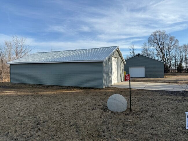
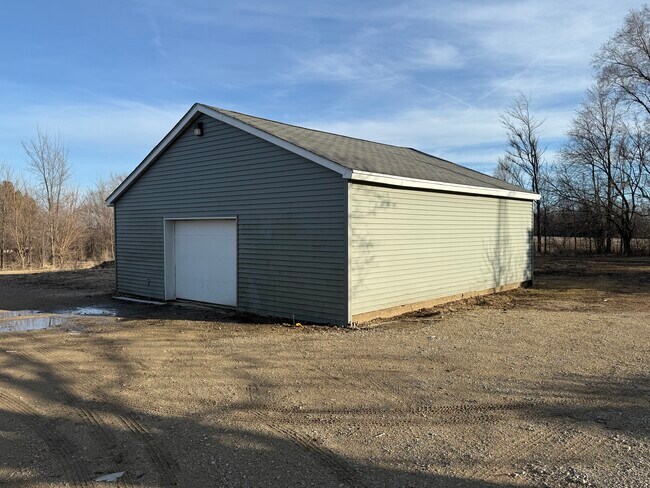
Property Record
3803 W Rockport Rd, Janesville, WI 53548

NEARBY LISTINGS FOR SALE OR LEASE
-
-
View all Janesville listings for sale on LoopNet.com
Property Detail
3803 W Rockport Rd
Janesville-Beloit, WI
Rock
617-82B
Wisconsin
Sfr
1.63 AC
X
Rock County
55105C0187E
Milwaukee/Madison
DEMOGRAPHICS near 3803 W Rockport Rd
1 Mile
3 Mile
5 Mile
2024 Total Population
1,013
25,672
50,244
2029 Population
1,026
25,834
50,645
Pop Growth 2024-2029
+ 1.28%
+ 0.63%
+ 0.80%
Average Age
44
41
41
2024 Total Households
366
10,441
20,920
HH Growth 2024-2029
+ 1.37%
+ 0.74%
+ 0.87%
Median Household Inc
$112,749
$62,929
$64,945
Avg Household Size
2.70
2.40
2.30
2024 Avg HH Vehicles
2.00
2.00
2.00
Median Home Value
$275,213
$165,175
$170,613
Median Year Built
1993
1966
1965
Nearby Places
Map Layers
Map Styles
 Street
 Aerial
- Restaurants
- Banks
- Shops
- Fitness
- Groceries
PUBLIC TRANSPORTATION
AIRPORT
Dane County Regional/Truax Field
DRIVE
WALK
Distance
Dane County Regional/Truax Field
64 min
46.4 mi
Chicago/Rockford International
DRIVE
WALK
Distance
Chicago/Rockford International
64 min
47.8 mi
SALE & LEASE HISTORY
LISTING DATE
SALE/LEASE

Mar 11, 2025
For Sale
Nearby Properties
Address
Land Use
TOTAL SIZE
Lot Size
Zoning
Address
Land Use
TOTAL SIZE
Lot Size
Zoning
18,480 SF
14.50 AC
O1
Address
Land Use
TOTAL SIZE
Lot Size
Zoning
Address
Land Use
TOTAL SIZE
Lot Size
Zoning
101,195 SF
1.40 AC
B6
Address
Land Use
TOTAL SIZE
Lot Size
Zoning
49,524 SF
1.57 AC
B6
Address
Land Use
TOTAL SIZE
Lot Size
Zoning
94,053 SF
4.52 AC
R3
Address
Land Use
TOTAL SIZE
Lot Size
Zoning
9,246 SF
0.59 AC
B5
Address
Land Use
TOTAL SIZE
Lot Size
Zoning
14.26 AC
R3
Address
Land Use
TOTAL SIZE
Lot Size
Zoning
14,736 SF
1.65 AC
B3
Address
Land Use
TOTAL SIZE
Lot Size
Zoning
22.23 AC
M2
Address
Land Use
TOTAL SIZE
Lot Size
Zoning
19,947 SF
0.80 AC
O1
Address
Land Use
TOTAL SIZE
Lot Size
Zoning
27.80 AC
M1
Address
Land Use
TOTAL SIZE
Lot Size
Zoning
25,544 SF
4.14 AC
B2
Address
Land Use
TOTAL SIZE
Lot Size
Zoning
8,336 SF
2.88 AC
B3
Address
Land Use
TOTAL SIZE
Lot Size
Zoning
20,643 SF
5.70 AC
B3
Address
Land Use
TOTAL SIZE
Lot Size
Zoning
33,124 SF
0.95 AC
B5
Address
Land Use
TOTAL SIZE
Lot Size
Zoning
47,169 SF
1.45 AC
B6
Address
Land Use
TOTAL SIZE
Lot Size
Zoning
13,372 SF
1.53 AC
B5
Address
Land Use
TOTAL SIZE
Lot Size
Zoning
11,679 SF
1.37 AC
B5
Address
Land Use
TOTAL SIZE
Lot Size
Zoning
9,286 SF
1.11 AC
M3
Address
Land Use
TOTAL SIZE
Lot Size
Zoning
33,000 SF
3.30 AC
B3
Address
Land Use
TOTAL SIZE
Lot Size
Zoning
8,044 SF
2.15 AC
R3
Address
Land Use
TOTAL SIZE
Lot Size
Zoning
5.17 AC
M2
Address
Land Use
TOTAL SIZE
Lot Size
Zoning
11,272 SF
1.74 AC
R3
Address
Land Use
TOTAL SIZE
Lot Size
Zoning
824 SF
59.48 AC
C2
Address
Land Use
TOTAL SIZE
Lot Size
Zoning
36,192 SF
0.32 AC
B6
Address
Land Use
TOTAL SIZE
Lot Size
Zoning
1,476 SF
0.97 AC
B3
Address
Land Use
TOTAL SIZE
Lot Size
Zoning
3,131 SF
4.82 AC
R3
Address
Land Use
TOTAL SIZE
Lot Size
Zoning
19.44 AC
M1
Address
Land Use
TOTAL SIZE
Lot Size
Zoning
8,670 SF
5.37 AC
O1
Address
Land Use
TOTAL SIZE
Lot Size
Zoning
4,000 SF
6.77 AC
M2
The World's #1 Commercial Real Estate Marketplace
Connect with us
© 2026 CoStar Group
The information above has been obtained from sources believed reliable. While we do not doubt its accuracy we have not verified it and make no guarantee, warranty or representation about it. It is your responsibility to independently confirm its accuracy and completeness. Any projections, opinions, assumptions, or estimates used are for example only and do not represent the current or future performance of the property. The value of this transaction to you depends on tax and other factors which should be evaluated by your tax, financial, and legal advisors. You and your advisors should conduct a careful, independent investigation of the property to determine to your satisfaction the suitability of the property for your needs.