Property Record
3803 W State Highway 29, Georgetown, TX 78628

Property Detail
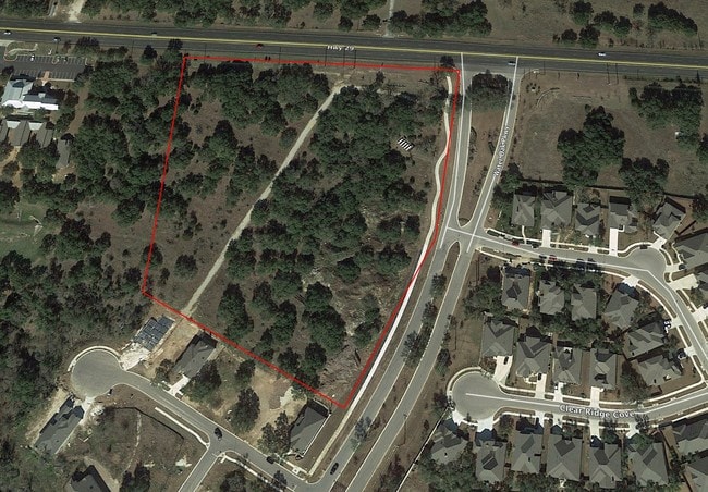
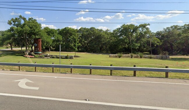
3803 W State Highway 29
Austin-Round Rock-San Marcos, TX
S11908 - WATER OAK NORTH (LT 1A REPLAT), BLOCK G, LOT 1AA, ACRES 8.4073
R577385
WILLIAMSON
Commercialacreage
Texas
B and X Area of moderate flood hazard, usually the area between the limits of the 100-year and 500-year floods.
1a,1
2024
8.41 AC
2025
Georgetown
020124
Austin
NEARBY LISTINGS FOR SALE OR LEASE
-
-
View all Georgetown listings for sale on LoopNet.com
DEMOGRAPHICS near 3803 W State Highway 29
1 mile
3 mile
5 mile
2025 Total Population
1,703
15,426
81,514
2030 Population
2,116
18,674
95,631
Pop Growth 2025-2030
+ 24.25%
+ 21.06%
+ 17.32%
Average Age
45
43
41
2025 Total Households
650
6,001
31,282
HH Growth 2025-2030
+ 24.46%
+ 21.35%
+ 17.73%
Median Household Inc
$165,416
$169,269
$127,534
Avg Household Size
2.60
2.60
2.60
2025 Avg HH Vehicles
2.00
2.00
2.00
Median Home Value
$464,821
$676,527
$564,464
Median Year Built
2011
2011
2010
Nearby Places
Map Layers
Map Styles
 Street
 Aerial
Transit
 Traffic
 Biking
Places
Listings with unknown addresses are not visible on the map
- Restaurants
- Banks
- Shops
- Fitness
- Groceries
SALE & LEASE HISTORY
LISTING DATE
SALE/LEASE

Jul 31, 2018
For Sale
Jul 02, 2024
For Sale
Jan 15, 2018
For Sale
Nearby Properties
Address
Land Use
TOTAL SIZE
Lot Size
Zoning
Address
Land Use
TOTAL SIZE
Lot Size
Zoning
393,202 SF
15.42 AC
Address
Land Use
TOTAL SIZE
Lot Size
Zoning
272,531 SF
14.97 AC
Address
Land Use
TOTAL SIZE
Lot Size
Zoning
213,599 SF
5.01 AC
Address
Land Use
TOTAL SIZE
Lot Size
Zoning
124,652 SF
14.96 AC
Address
Land Use
TOTAL SIZE
Lot Size
Zoning
148,228 SF
21.32 AC
Address
Land Use
TOTAL SIZE
Lot Size
Zoning
2,086 SF
25.66 AC
Address
Land Use
TOTAL SIZE
Lot Size
Zoning
40,042 SF
19.78 AC
Address
Land Use
TOTAL SIZE
Lot Size
Zoning
53,794 SF
19.77 AC
Address
Land Use
TOTAL SIZE
Lot Size
Zoning
125,929 SF
2.18 AC
Address
Land Use
TOTAL SIZE
Lot Size
Zoning
Address
Land Use
TOTAL SIZE
Lot Size
Zoning
72,199 SF
7.85 AC
Address
Land Use
TOTAL SIZE
Lot Size
Zoning
20,206 SF
18.52 AC
Address
Land Use
TOTAL SIZE
Lot Size
Zoning
Address
Land Use
TOTAL SIZE
Lot Size
Zoning
32,092 SF
0.14 AC
Address
Land Use
TOTAL SIZE
Lot Size
Zoning
61,130 SF
7.71 AC
Address
Land Use
TOTAL SIZE
Lot Size
Zoning
89.42 AC
Address
Land Use
TOTAL SIZE
Lot Size
Zoning
1,508 SF
7.01 AC
Address
Land Use
TOTAL SIZE
Lot Size
Zoning
4,142 SF
1.71 AC
Address
Land Use
TOTAL SIZE
Lot Size
Zoning
17,032 SF
3.65 AC
Address
Land Use
TOTAL SIZE
Lot Size
Zoning
Address
Land Use
TOTAL SIZE
Lot Size
Zoning
7,180 SF
4.72 AC
Address
Land Use
TOTAL SIZE
Lot Size
Zoning
13,710 SF
3.65 AC
Address
Land Use
TOTAL SIZE
Lot Size
Zoning
4,698 SF
1.50 AC
Address
Land Use
TOTAL SIZE
Lot Size
Zoning
32,092 SF
14.05 AC
Address
Land Use
TOTAL SIZE
Lot Size
Zoning
17,426 SF
2.46 AC
Address
Land Use
TOTAL SIZE
Lot Size
Zoning
10.02 AC
Address
Land Use
TOTAL SIZE
Lot Size
Zoning
Address
Land Use
TOTAL SIZE
Lot Size
Zoning
Address
Land Use
TOTAL SIZE
Lot Size
Zoning
45.29 AC
The World's #1 Commercial Real Estate Marketplace
Connect with us
© 2026 CoStar Group
The information above has been obtained from sources believed reliable. While we do not doubt its accuracy we have not verified it and make no guarantee, warranty or representation about it. It is your responsibility to independently confirm its accuracy and completeness. Any projections, opinions, assumptions, or estimates used are for example only and do not represent the current or future performance of the property. The value of this transaction to you depends on tax and other factors which should be evaluated by your tax, financial, and legal advisors. You and your advisors should conduct a careful, independent investigation of the property to determine to your satisfaction the suitability of the property for your needs.