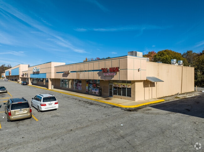
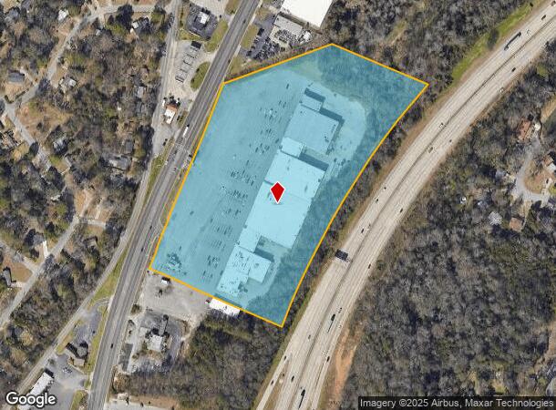
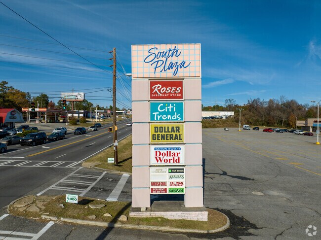
Property Record
3804 Pio Nono Ave, Macon, GA 31206
NEARBY LISTINGS FOR SALE OR LEASE
Property Detail
3804 Pio Nono Ave
Stripcommercialcenter
Bibb
X
Georgia
13021C0141G
12.31 AC
2025
Suburban Macon
2025
Atlanta
012600
Macon-Bibb County, GA
100,170 SF
O102-0220
DEMOGRAPHICS near 3804 Pio Nono Ave
1 Mile
3 Mile
5 Mile
2024 Total Population
6,899
42,409
80,570
2029 Population
6,932
42,627
80,792
Pop Growth 2024-2029
+ 0.48%
+ 0.51%
+ 0.28%
Average Age
36
36
37
2024 Total Households
2,612
15,281
31,827
HH Growth 2024-2029
+ 0.54%
+ 0.84%
+ 0.33%
Median Household Inc
$28,388
$30,673
$35,258
Avg Household Size
2.50
2.50
2.40
2024 Avg HH Vehicles
1.00
1.00
1.00
Median Home Value
$64,166
$72,601
$109,691
Median Year Built
1960
1964
1966
Nearby Places
Map Layers
Map Styles
 Street
 Aerial
- Restaurants
- Banks
- Shops
- Fitness
- Groceries
SALE & LEASE HISTORY
LISTING DATE
SALE/LEASE

Aug 17, 2017
For Lease
Nearby Properties
Address
Land Use
TOTAL SIZE
Lot Size
Zoning
Address
Land Use
TOTAL SIZE
Lot Size
Zoning
63,394 SF
5.30 AC
M-1/R-3
Address
Land Use
TOTAL SIZE
Lot Size
Zoning
181,396 SF
44.77 AC
R-1A
Address
Land Use
TOTAL SIZE
Lot Size
Zoning
12,817 SF
357.49 AC
M-2
Address
Land Use
TOTAL SIZE
Lot Size
Zoning
199,096 SF
22.03 AC
R-2
Address
Land Use
TOTAL SIZE
Lot Size
Zoning
1,428 SF
64.46 AC
R-1A
Address
Land Use
TOTAL SIZE
Lot Size
Zoning
18,128 SF
95 AC
M-2
Address
Land Use
TOTAL SIZE
Lot Size
Zoning
98,928 SF
12.32 AC
R-3
Address
Land Use
TOTAL SIZE
Lot Size
Zoning
110,153 SF
22 AC
R-2
Address
Land Use
TOTAL SIZE
Lot Size
Zoning
46,288 SF
1.80 AC
PDE
Address
Land Use
TOTAL SIZE
Lot Size
Zoning
33,248 SF
10.18 AC
R-3
Address
Land Use
TOTAL SIZE
Lot Size
Zoning
119,564 SF
3.89 AC
R-3
Address
Land Use
TOTAL SIZE
Lot Size
Zoning
96,512 SF
11.30 AC
PDE
Address
Land Use
TOTAL SIZE
Lot Size
Zoning
58,730 SF
3.42 AC
R-3
Address
Land Use
TOTAL SIZE
Lot Size
Zoning
46,174 SF
9.67 AC
R-2
Address
Land Use
TOTAL SIZE
Lot Size
Zoning
133,862 SF
25.44 AC
C-2
Address
Land Use
TOTAL SIZE
Lot Size
Zoning
8,480 SF
7.92 AC
HPD-BH
Address
Land Use
TOTAL SIZE
Lot Size
Zoning
108,418 SF
24.45 AC
R-1A
Address
Land Use
TOTAL SIZE
Lot Size
Zoning
30,096 SF
6.63 AC
PDR
Address
Land Use
TOTAL SIZE
Lot Size
Zoning
44,323 SF
2.76 AC
PDE
Address
Land Use
TOTAL SIZE
Lot Size
Zoning
132,423 SF
20.38 AC
C-2
Address
Land Use
TOTAL SIZE
Lot Size
Zoning
32,300 SF
24.40 AC
R-2
Address
Land Use
TOTAL SIZE
Lot Size
Zoning
174,764 SF
Address
Land Use
TOTAL SIZE
Lot Size
Zoning
100,192 SF
30.29 AC
C-2
Address
Land Use
TOTAL SIZE
Lot Size
Zoning
5,400 SF
2.97 AC
HPD-BH
Address
Land Use
TOTAL SIZE
Lot Size
Zoning
3,196 SF
12.94 AC
R-3
Address
Land Use
TOTAL SIZE
Lot Size
Zoning
280,569 SF
Address
Land Use
TOTAL SIZE
Lot Size
Zoning
87,002 SF
3.73 AC
PDR/R-3
Address
Land Use
TOTAL SIZE
Lot Size
Zoning
4,966 SF
6.05 AC
PDR
Address
Land Use
TOTAL SIZE
Lot Size
Zoning
6,120 SF
4.95 AC
C-2
Address
Land Use
TOTAL SIZE
Lot Size
Zoning
3,500 SF
6.07 AC
R-3
The World's #1 Commercial Real Estate Marketplace
Connect with us
© 2025 CoStar Group
The information above has been obtained from sources believed reliable. While we do not doubt its accuracy we have not verified it and make no guarantee, warranty or representation about it. It is your responsibility to independently confirm its accuracy and completeness. Any projections, opinions, assumptions, or estimates used are for example only and do not represent the current or future performance of the property. The value of this transaction to you depends on tax and other factors which should be evaluated by your tax, financial, and legal advisors. You and your advisors should conduct a careful, independent investigation of the property to determine to your satisfaction the suitability of the property for your needs.