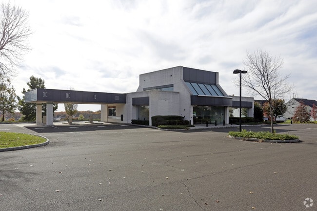
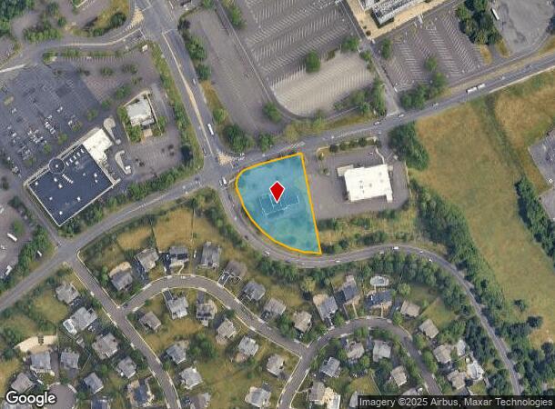
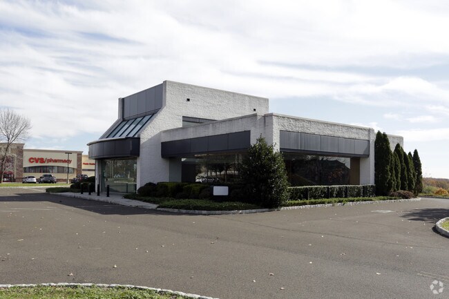
Property Record
3805 Neshaminy Blvd, Bensalem, PA 19020
Current Lease Availabilities
NEARBY LISTINGS FOR SALE OR LEASE
Property Detail
3805 Neshaminy Blvd
02-098-095
1.38AC LOT #1 SE COR R OCKHILL DR EXTENSION & NESHAMINY BLVD
Financialbuilding
Bucks
X
Pennsylvania
42017C0439J
1
2024
1.38 AC
2025
Lower Bucks County
100206
Philadelphia
3,753 SF
Philadelphia-Camden-Wilmington, PA-NJ-DE-MD
DEMOGRAPHICS near 3805 Neshaminy Blvd
1 Mile
3 Mile
5 Mile
2024 Total Population
5,768
95,752
260,302
2029 Population
5,683
94,773
255,926
Pop Growth 2024-2029
(1.47%)
(1.02%)
(1.68%)
Average Age
42
42
42
2024 Total Households
2,469
36,084
97,870
HH Growth 2024-2029
(1.82%)
(1.13%)
(1.85%)
Median Household Inc
$69,971
$85,551
$83,748
Avg Household Size
2.30
2.60
2.60
2024 Avg HH Vehicles
2.00
2.00
2.00
Median Home Value
$329,861
$313,216
$304,669
Median Year Built
1975
1972
1968
Nearby Places
Map Layers
Map Styles
 Street
 Aerial
- Restaurants
- Banks
- Shops
- Fitness
- Groceries
PUBLIC TRANSPORTATION
COMMUTER RAIL
Neshaminy Falls (R3 - Southeastern Pennsylvania Transportation Authority Regional Rail (SEPTA Regional Rail))
DRIVE
WALK
Distance
Neshaminy Falls (R3 - Southeastern Pennsylvania Transportation Authority Regional Rail (SEPTA Regional Rail))
4 min
1.5 mi
Trevose (R3 - Southeastern Pennsylvania Transportation Authority Regional Rail (SEPTA Regional Rail))
DRIVE
WALK
Distance
Trevose (R3 - Southeastern Pennsylvania Transportation Authority Regional Rail (SEPTA Regional Rail))
6 min
2.5 mi
AIRPORT
Trenton Mercer
DRIVE
WALK
Distance
Trenton Mercer
24 min
15.1 mi
Philadelphia International
DRIVE
WALK
Distance
Philadelphia International
47 min
30.0 mi
Freight Ports
Port of Philadelphia
DRIVE
WALK
Distance
Port of Philadelphia
27 min
16.3 mi
Nearby Properties
Address
Land Use
TOTAL SIZE
Lot Size
Zoning
Address
Land Use
TOTAL SIZE
Lot Size
Zoning
34,350 SF
336 AC
SPPOA
Address
Land Use
TOTAL SIZE
Lot Size
Zoning
70,995 SF
5.34 AC
RSD1
Address
Land Use
TOTAL SIZE
Lot Size
Zoning
410.98 AC
R2
Address
Land Use
TOTAL SIZE
Lot Size
Zoning
283,878 SF
63.36 AC
RSA3
Address
Land Use
TOTAL SIZE
Lot Size
Zoning
118,001 SF
25.60 AC
I2
Address
Land Use
TOTAL SIZE
Lot Size
Zoning
453,038 SF
34.79 AC
I1
Address
Land Use
TOTAL SIZE
Lot Size
Zoning
300,700 SF
30.41 AC
I1
Address
Land Use
TOTAL SIZE
Lot Size
Zoning
200.39 AC
SPPOP
Address
Land Use
TOTAL SIZE
Lot Size
Zoning
207,500 SF
16.18 AC
I1
Address
Land Use
TOTAL SIZE
Lot Size
Zoning
241,392 SF
24.15 AC
I1
Address
Land Use
TOTAL SIZE
Lot Size
Zoning
136,315 SF
11.38 AC
CA1
Address
Land Use
TOTAL SIZE
Lot Size
Zoning
229,183 SF
19.61 AC
I1
Address
Land Use
TOTAL SIZE
Lot Size
Zoning
189,541 SF
13.58 AC
RM2
Address
Land Use
TOTAL SIZE
Lot Size
Zoning
154,048 SF
15.74 AC
I1
Address
Land Use
TOTAL SIZE
Lot Size
Zoning
1,200 SF
18.71 AC
RSD1
Address
Land Use
TOTAL SIZE
Lot Size
Zoning
169,109 SF
20.43 AC
I2
Address
Land Use
TOTAL SIZE
Lot Size
Zoning
131,987 SF
10.56 AC
I1
Address
Land Use
TOTAL SIZE
Lot Size
Zoning
116,000 SF
224.30 AC
SPPOP
Address
Land Use
TOTAL SIZE
Lot Size
Zoning
112,471 SF
3.31 AC
RSD1
Address
Land Use
TOTAL SIZE
Lot Size
Zoning
129,890 SF
22.15 AC
RSA3
Address
Land Use
TOTAL SIZE
Lot Size
Zoning
63,513 SF
4.61 AC
I1
Address
Land Use
TOTAL SIZE
Lot Size
Zoning
96,445 SF
12.93 AC
I2
Address
Land Use
TOTAL SIZE
Lot Size
Zoning
75,280 SF
7.98 AC
CA1
Address
Land Use
TOTAL SIZE
Lot Size
Zoning
100,000 SF
7.27 AC
I1
Address
Land Use
TOTAL SIZE
Lot Size
Zoning
75,497 SF
7.67 AC
CA1
Address
Land Use
TOTAL SIZE
Lot Size
Zoning
155,640 SF
9.62 AC
I1
Address
Land Use
TOTAL SIZE
Lot Size
Zoning
11.06 AC
SPPOA
Address
Land Use
TOTAL SIZE
Lot Size
Zoning
242,301 SF
0.40 AC
RSA3
Address
Land Use
TOTAL SIZE
Lot Size
Zoning
1,135 SF
12.37 AC
SPPOA
Address
Land Use
TOTAL SIZE
Lot Size
Zoning
78,110 SF
12.20 AC
RSA4
The World's #1 Commercial Real Estate Marketplace
Connect with us
© 2025 CoStar Group
The information above has been obtained from sources believed reliable. While we do not doubt its accuracy we have not verified it and make no guarantee, warranty or representation about it. It is your responsibility to independently confirm its accuracy and completeness. Any projections, opinions, assumptions, or estimates used are for example only and do not represent the current or future performance of the property. The value of this transaction to you depends on tax and other factors which should be evaluated by your tax, financial, and legal advisors. You and your advisors should conduct a careful, independent investigation of the property to determine to your satisfaction the suitability of the property for your needs.