Property Record
3805 Vandalia Rd, Des Moines, IA 50317
NEARBY LISTINGS FOR SALE OR LEASE
-
-
View all Des Moines listings for sale on LoopNet.com
Property Detail
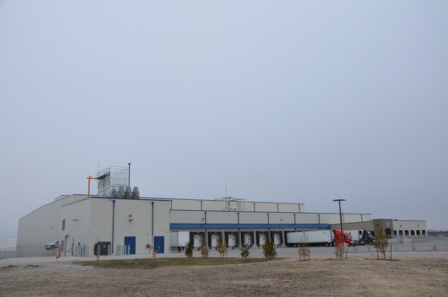
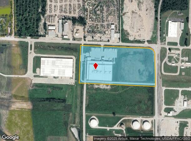
3805 Vandalia Rd
Des Moines-West Des Moines, IA
Sec 17-78-23
050/04315-001-004
PARCEL 2016-123 BK 16092 PG 255 BEG 1416.77F W & 50F S N 1/4 CORNER THN E 1272.55F SELY 206.92F S 576.53F W 1431.6F NE 705.57F TO POB (EX COM N 1/4 COR SEC 17 THN S 179.09F W 16.45F TO POB THN S 365.34F N 338.93F N 69.39F NW 22.10F SELY ALNG CRV 67.0
Warehouse
Polk
0
Iowa
2025
22.81 AC
005300
Northeast
175,854 SF
Des Moines
DEMOGRAPHICS near 3805 Vandalia Rd
1 Mile
3 Mile
5 Mile
2024 Total Population
0
29,924
113,018
2029 Population
0
30,979
117,704
Pop Growth 2024-2029
0.00%
+ 3.53%
+ 4.15%
Average Age
0
38
38
2024 Total Households
0
11,108
44,901
HH Growth 2024-2029
0.00%
+ 3.68%
+ 4.45%
Median Household Inc
$0
$67,686
$60,783
Avg Household Size
.00
2.60
2.40
2024 Avg HH Vehicles
.00
2.00
2.00
Median Home Value
$0
$186,343
$161,941
Median Year Built
0
1980
1973
Nearby Places
Map Layers
Map Styles
 Street
 Aerial
- Restaurants
- Banks
- Shops
- Fitness
- Groceries
PUBLIC TRANSPORTATION
AIRPORT
Des Moines International
DRIVE
WALK
Distance
Des Moines International
22 min
10.6 mi
Freight Ports
Port Milwaukee
DRIVE
WALK
Distance
Port Milwaukee
418 min
373.7 mi
SALE & LEASE HISTORY
LISTING DATE
SALE/LEASE

Nov 27, 2017
For Sale
Mar 15, 2017
For Sale
Dec 27, 2016
For Sale
Nearby Properties
Address
Land Use
TOTAL SIZE
Lot Size
Zoning
Address
Land Use
TOTAL SIZE
Lot Size
Zoning
177,094 SF
24.60 AC
Address
Land Use
TOTAL SIZE
Lot Size
Zoning
475,929 SF
49.86 AC
M2
Address
Land Use
TOTAL SIZE
Lot Size
Zoning
342,000 SF
22.18 AC
Address
Land Use
TOTAL SIZE
Lot Size
Zoning
218,593 SF
19.31 AC
M-2
Address
Land Use
TOTAL SIZE
Lot Size
Zoning
1,890,511 SF
39.03 AC
M-2
Address
Land Use
TOTAL SIZE
Lot Size
Zoning
178,415 SF
13.35 AC
R-6
Address
Land Use
TOTAL SIZE
Lot Size
Zoning
155,276 SF
6.66 AC
R-4
Address
Land Use
TOTAL SIZE
Lot Size
Zoning
201,072 SF
26.81 AC
Address
Land Use
TOTAL SIZE
Lot Size
Zoning
38.16 AC
PUD
Address
Land Use
TOTAL SIZE
Lot Size
Zoning
155,640 SF
9.15 AC
R-6
Address
Land Use
TOTAL SIZE
Lot Size
Zoning
138,490 SF
10.01 AC
R-6
Address
Land Use
TOTAL SIZE
Lot Size
Zoning
126,830 SF
6.53 AC
Address
Land Use
TOTAL SIZE
Lot Size
Zoning
65,079 SF
6.19 AC
R-2
Address
Land Use
TOTAL SIZE
Lot Size
Zoning
58,366 SF
11.58 AC
Address
Land Use
TOTAL SIZE
Lot Size
Zoning
89,286 SF
14.49 AC
R1-60
Address
Land Use
TOTAL SIZE
Lot Size
Zoning
123,059 SF
27.23 AC
M2
Address
Land Use
TOTAL SIZE
Lot Size
Zoning
99,200 SF
7 AC
I-2
Address
Land Use
TOTAL SIZE
Lot Size
Zoning
44,200 SF
3.41 AC
Address
Land Use
TOTAL SIZE
Lot Size
Zoning
67,104 SF
4.04 AC
R-6
Address
Land Use
TOTAL SIZE
Lot Size
Zoning
1,326 SF
5.15 AC
I-3
Address
Land Use
TOTAL SIZE
Lot Size
Zoning
56,281 SF
5.80 AC
C-1
Address
Land Use
TOTAL SIZE
Lot Size
Zoning
16.80 AC
M-1
Address
Land Use
TOTAL SIZE
Lot Size
Zoning
38,172 SF
3.27 AC
C-2
Address
Land Use
TOTAL SIZE
Lot Size
Zoning
49,708 SF
7.33 AC
R-3
Address
Land Use
TOTAL SIZE
Lot Size
Zoning
54,876 SF
7.05 AC
I-2
Address
Land Use
TOTAL SIZE
Lot Size
Zoning
67,602 SF
3.71 AC
R-3
Address
Land Use
TOTAL SIZE
Lot Size
Zoning
34,562 SF
2.01 AC
R-3
Address
Land Use
TOTAL SIZE
Lot Size
Zoning
2,368 SF
19.47 AC
I-3
Address
Land Use
TOTAL SIZE
Lot Size
Zoning
23,900 SF
8.49 AC
The World's #1 Commercial Real Estate Marketplace
Connect with us
© 2026 CoStar Group
The information above has been obtained from sources believed reliable. While we do not doubt its accuracy we have not verified it and make no guarantee, warranty or representation about it. It is your responsibility to independently confirm its accuracy and completeness. Any projections, opinions, assumptions, or estimates used are for example only and do not represent the current or future performance of the property. The value of this transaction to you depends on tax and other factors which should be evaluated by your tax, financial, and legal advisors. You and your advisors should conduct a careful, independent investigation of the property to determine to your satisfaction the suitability of the property for your needs.