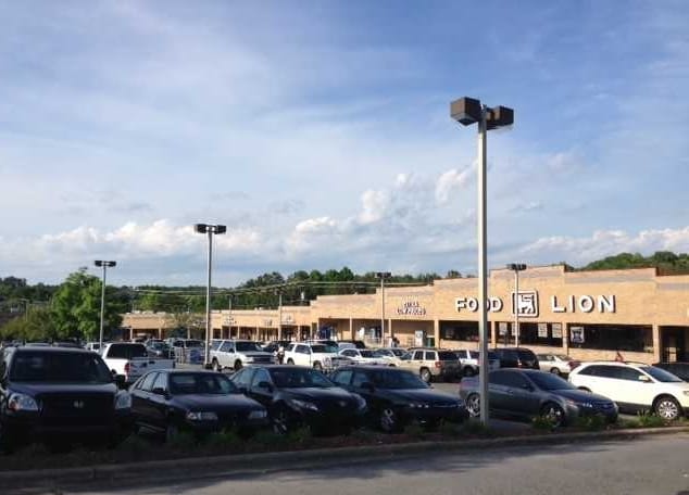
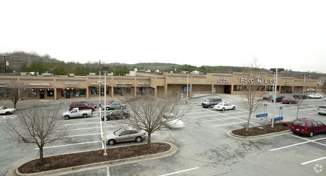
Property Record
3808 Guess Rd, Durham, NC 27705

Property Detail
3808 Guess Rd
172752
PROP-M M FOWLER INC DBA/FOODLION PL:000156-000035
Regionalshoppingcenterormallwithanchorstore
Durham
CC(D)
North Carolina
AE The base floodplain where base flood elevations are provided. AE Zones are now used on new format FIRMs instead of A1-A30 Zones.
9.34 AC
2025
North Durham
2025
Raleigh/Durham
001711
Durham-Chapel Hill, NC
66,606 SF
NEARBY LISTINGS FOR SALE OR LEASE
DEMOGRAPHICS near 3808 Guess Rd
1 mile
3 mile
5 mile
2025 Total Population
8,948
54,363
120,935
2030 Population
9,468
57,258
127,663
Pop Growth 2025-2030
+ 5.81%
+ 5.33%
+ 5.56%
Average Age
38
41
39
2025 Total Households
3,888
22,499
50,760
HH Growth 2025-2030
+ 6.02%
+ 5.55%
+ 6.06%
Median Household Inc
$63,658
$77,955
$71,454
Avg Household Size
2.30
2.30
2.20
2025 Avg HH Vehicles
2.00
2.00
2.00
Median Home Value
$331,690
$393,233
$407,017
Median Year Built
1988
1985
1984
Nearby Places
Map Layers
Map Styles
 Street
 Aerial
Layers
 Traffic
 Biking
Places
Listings with unknown addresses are not visible on the map
- Restaurants
- Banks
- Shops
- Fitness
- Groceries
PUBLIC TRANSPORTATION
COMMUTER RAIL
Drive
Walk
Distance
12 min
5.2 mi
AIRPORT
Raleigh-Durham International
Drive
Walk
Distance
Raleigh-Durham International
30 min
18.1 mi
SALE & LEASE HISTORY
LISTING DATE
SALE/LEASE

Sep 25, 2016
For Lease
Nearby Properties
Address
Land Use
TOTAL SIZE
Lot Size
Zoning
Address
Land Use
TOTAL SIZE
Lot Size
Zoning
749,544 SF
100.49 AC
OI,RS-8
Address
Land Use
TOTAL SIZE
Lot Size
Zoning
758,666 SF
99.64 AC
PDR 2.000
Address
Land Use
TOTAL SIZE
Lot Size
Zoning
12,440 SF
36.51 AC
PDR 2.000
Address
Land Use
TOTAL SIZE
Lot Size
Zoning
485,295 SF
27.35 AC
RS-8
Address
Land Use
TOTAL SIZE
Lot Size
Zoning
6,753 SF
22.99 AC
OI(D)
Address
Land Use
TOTAL SIZE
Lot Size
Zoning
166,866 SF
76.52 AC
RS-10
Address
Land Use
TOTAL SIZE
Lot Size
Zoning
297,910 SF
39.63 AC
RS-20
Address
Land Use
TOTAL SIZE
Lot Size
Zoning
12,468 SF
13.33 AC
RU-M(D)
Address
Land Use
TOTAL SIZE
Lot Size
Zoning
256,985 SF
37.98 AC
RR
Address
Land Use
TOTAL SIZE
Lot Size
Zoning
6,822 SF
24.64 AC
PDR 2.000
Address
Land Use
TOTAL SIZE
Lot Size
Zoning
130,550 SF
4.07 AC
I
Address
Land Use
TOTAL SIZE
Lot Size
Zoning
4,644 SF
19.04 AC
RU-M
Address
Land Use
TOTAL SIZE
Lot Size
Zoning
15,720 SF
16.18 AC
PDR 10.000
Address
Land Use
TOTAL SIZE
Lot Size
Zoning
7,056 SF
25.68 AC
RS-M
Address
Land Use
TOTAL SIZE
Lot Size
Zoning
6,936 SF
11.42 AC
PDR 2.000
Address
Land Use
TOTAL SIZE
Lot Size
Zoning
176,751 SF
17.77 AC
OI
Address
Land Use
TOTAL SIZE
Lot Size
Zoning
8,824 SF
15.96 AC
RS-M
Address
Land Use
TOTAL SIZE
Lot Size
Zoning
136,387 SF
11.82 AC
IL
Address
Land Use
TOTAL SIZE
Lot Size
Zoning
15,140 SF
19.79 AC
RS-M
Address
Land Use
TOTAL SIZE
Lot Size
Zoning
3.80 AC
PDR 7.200
Address
Land Use
TOTAL SIZE
Lot Size
Zoning
141,352 SF
8.40 AC
IL
Address
Land Use
TOTAL SIZE
Lot Size
Zoning
22,368 SF
20.40 AC
PDR 4.990
Address
Land Use
TOTAL SIZE
Lot Size
Zoning
135,246 SF
17.10 AC
CG(D)
Address
Land Use
TOTAL SIZE
Lot Size
Zoning
139,368 SF
5.70 AC
RU-M
Address
Land Use
TOTAL SIZE
Lot Size
Zoning
17,088 SF
15.96 AC
PDR 10.000
Address
Land Use
TOTAL SIZE
Lot Size
Zoning
8,400 SF
16.52 AC
RS-M(D)
Address
Land Use
TOTAL SIZE
Lot Size
Zoning
6,570 SF
20.83 AC
RS-M(D)
Address
Land Use
TOTAL SIZE
Lot Size
Zoning
181,738 SF
66.62 AC
RR
Address
Land Use
TOTAL SIZE
Lot Size
Zoning
185,363 SF
12.24 AC
CC
Address
Land Use
TOTAL SIZE
Lot Size
Zoning
14,112 SF
26.48 AC
RS-M
The World's #1 Commercial Real Estate Marketplace
Connect with us
© 2026 CoStar Group
The information above has been obtained from sources believed reliable. While we do not doubt its accuracy we have not verified it and make no guarantee, warranty or representation about it. It is your responsibility to independently confirm its accuracy and completeness. Any projections, opinions, assumptions, or estimates used are for example only and do not represent the current or future performance of the property. The value of this transaction to you depends on tax and other factors which should be evaluated by your tax, financial, and legal advisors. You and your advisors should conduct a careful, independent investigation of the property to determine to your satisfaction the suitability of the property for your needs.