Property Record
381 E Outer Rd, Poplar Bluff, MO 63901
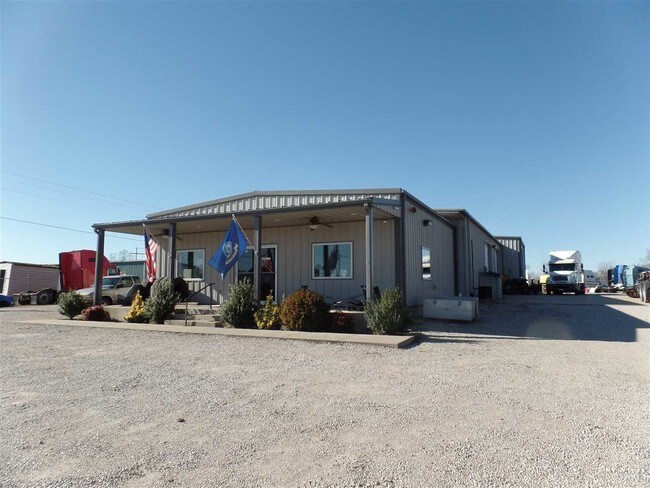

Property Detail
381 E Outer Rd
Poplar Bluff, MO
SHERRY VISTA SUB: LOT 27 LYING EAST OF NEW US ROUT E 67: SHERRY VISTA SUB
109-13-04-18-0-003-002-022-000
Butler
Officebuilding
Missouri
B and X Area of moderate flood hazard, usually the area between the limits of the 100-year and 500-year floods.
27
2025
1.30 AC
2025
Missouri South Area
950202
Other Market Areas
1,264 SF
NEARBY LISTINGS FOR SALE OR LEASE
-
-
View all Poplar Bluff listings for sale on LoopNet.com
DEMOGRAPHICS near 381 E Outer Rd
1 mile
3 mile
5 mile
2025 Total Population
1,153
5,324
23,000
2030 Population
1,143
5,270
22,770
Pop Growth 2025-2030
(0.87%)
(1.01%)
(1.00%)
Average Age
41
41
40
2025 Total Households
465
2,151
9,353
HH Growth 2025-2030
(0.65%)
(1.07%)
(1.04%)
Median Household Inc
$59,038
$58,536
$46,161
Avg Household Size
2.40
2.40
2.40
2025 Avg HH Vehicles
2.00
2.00
2.00
Median Home Value
$166,193
$159,866
$144,732
Median Year Built
1989
1987
1979
Nearby Places
Map Layers
Map Styles
 Street
 Aerial
Layers
 Traffic
 Biking
Places
Listings with unknown addresses are not visible on the map
- Restaurants
- Banks
- Shops
- Fitness
- Groceries
PUBLIC TRANSPORTATION
COMMUTER RAIL
Poplar Bluff Amtrak Station (Texas Eagle - Amtrak)
Drive
Walk
Distance
Poplar Bluff Amtrak Station (Texas Eagle - Amtrak)
10 min
5.5 mi
Freight Ports
Tulsa Port of Inola
Drive
Walk
Distance
Tulsa Port of Inola
408 min
359.0 mi
SALE & LEASE HISTORY
LISTING DATE
SALE/LEASE

Oct 28, 2016
For Sale
Jul 20, 2017
For Sale
Jul 12, 2017
For Sale
Nearby Properties
Address
Land Use
TOTAL SIZE
Lot Size
Zoning
Address
Land Use
TOTAL SIZE
Lot Size
Zoning
10,612 SF
30 AC
Address
Land Use
TOTAL SIZE
Lot Size
Zoning
13,200 SF
30.45 AC
Address
Land Use
TOTAL SIZE
Lot Size
Zoning
20,952 SF
5.80 AC
Address
Land Use
TOTAL SIZE
Lot Size
Zoning
125,000 SF
5.21 AC
Address
Land Use
TOTAL SIZE
Lot Size
Zoning
16,746 SF
9.42 AC
Address
Land Use
TOTAL SIZE
Lot Size
Zoning
27,059 SF
7.15 AC
Address
Land Use
TOTAL SIZE
Lot Size
Zoning
1,050 SF
9.40 AC
Address
Land Use
TOTAL SIZE
Lot Size
Zoning
17,002 SF
6.40 AC
Address
Land Use
TOTAL SIZE
Lot Size
Zoning
30,381 SF
9.14 AC
Address
Land Use
TOTAL SIZE
Lot Size
Zoning
64,500 SF
9.84 AC
Address
Land Use
TOTAL SIZE
Lot Size
Zoning
40,198 SF
6 AC
Address
Land Use
TOTAL SIZE
Lot Size
Zoning
5.07 AC
Address
Land Use
TOTAL SIZE
Lot Size
Zoning
9,654 SF
17.40 AC
Address
Land Use
TOTAL SIZE
Lot Size
Zoning
18,449 SF
22.52 AC
Address
Land Use
TOTAL SIZE
Lot Size
Zoning
36,473 SF
3.96 AC
Address
Land Use
TOTAL SIZE
Lot Size
Zoning
13,564 SF
1.49 AC
Address
Land Use
TOTAL SIZE
Lot Size
Zoning
3,600 SF
6.71 AC
Address
Land Use
TOTAL SIZE
Lot Size
Zoning
5,151 SF
5.37 AC
Address
Land Use
TOTAL SIZE
Lot Size
Zoning
9,634 SF
0.72 AC
Address
Land Use
TOTAL SIZE
Lot Size
Zoning
8,060 SF
3.92 AC
Address
Land Use
TOTAL SIZE
Lot Size
Zoning
7,931 SF
3.74 AC
Address
Land Use
TOTAL SIZE
Lot Size
Zoning
5,487 SF
2 AC
Address
Land Use
TOTAL SIZE
Lot Size
Zoning
7,440 SF
6.01 AC
Address
Land Use
TOTAL SIZE
Lot Size
Zoning
9,100 SF
0.21 AC
Address
Land Use
TOTAL SIZE
Lot Size
Zoning
8,129 SF
Address
Land Use
TOTAL SIZE
Lot Size
Zoning
6,492 SF
4.59 AC
Address
Land Use
TOTAL SIZE
Lot Size
Zoning
7,196 SF
1.05 AC
Address
Land Use
TOTAL SIZE
Lot Size
Zoning
10,418 SF
2.35 AC
Address
Land Use
TOTAL SIZE
Lot Size
Zoning
34,521 SF
5.01 AC
Address
Land Use
TOTAL SIZE
Lot Size
Zoning
1,200 SF
3.84 AC
The World's #1 Commercial Real Estate Marketplace
Connect with us
© 2026 CoStar Group
The information above has been obtained from sources believed reliable. While we do not doubt its accuracy we have not verified it and make no guarantee, warranty or representation about it. It is your responsibility to independently confirm its accuracy and completeness. Any projections, opinions, assumptions, or estimates used are for example only and do not represent the current or future performance of the property. The value of this transaction to you depends on tax and other factors which should be evaluated by your tax, financial, and legal advisors. You and your advisors should conduct a careful, independent investigation of the property to determine to your satisfaction the suitability of the property for your needs.