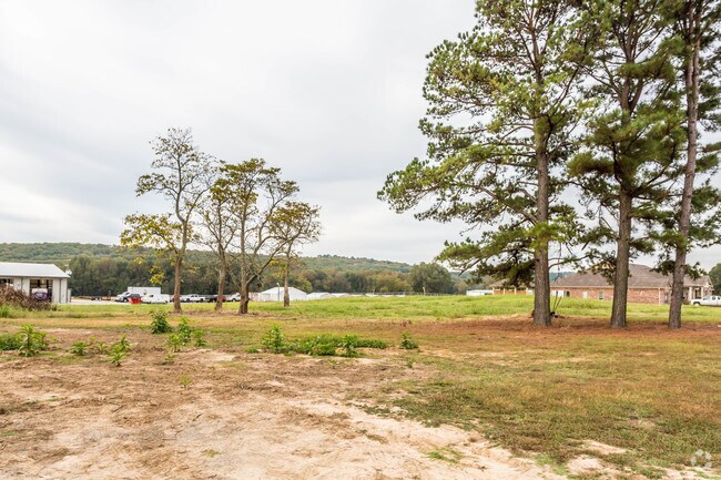
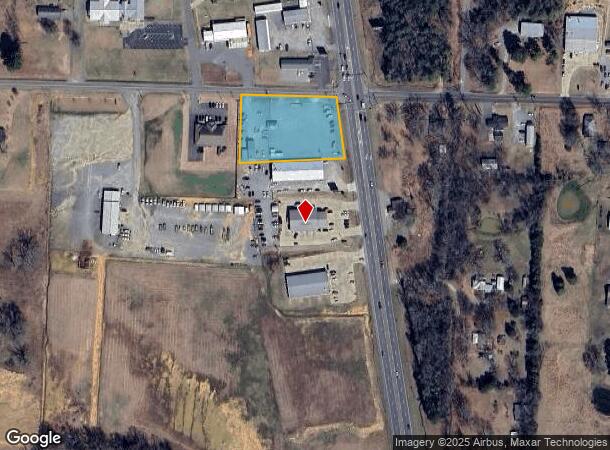
Property Record
381 Highway 65 N, Conway, AR 72032

NEARBY LISTINGS FOR SALE OR LEASE
Property Detail
381 Highway 65 N
001-09373-002
PT N 1/2 NE BEAVERFORK FD 50
Officebuilding
Faulkner
X
Arkansas
05045C0170J
1.59 AC
2025
Faulkner County
2025
Little Rock/N Little Rock
030401
Little Rock-North Little Rock-Conway, AR
400 SF
DEMOGRAPHICS near 381 Highway 65 N
1 mile
3 mile
5 mile
2024 Total Population
1,177
10,930
44,025
2029 Population
1,270
12,010
47,649
Pop Growth 2024-2029
+ 7.90%
+ 9.88%
+ 8.23%
Average Age
42
39
37
2024 Total Households
440
4,167
17,474
HH Growth 2024-2029
+ 7.95%
+ 10.22%
+ 8.44%
Median Household Inc
$84,005
$67,069
$52,300
Avg Household Size
2.70
2.50
2.40
2024 Avg HH Vehicles
2.00
2.00
2.00
Median Home Value
$244,318
$215,820
$189,712
Median Year Built
1992
1999
1992
Nearby Places
Map Layers
Map Styles
 Street
 Aerial
Transit
 Traffic
 Biking
Places
Listings with unknown addresses are not visible on the map
- Restaurants
- Banks
- Shops
- Fitness
- Groceries
PUBLIC TRANSPORTATION
AIRPORT
Bill and Hillary Clinton Ntl/Adams Field
Drive
Walk
Distance
Bill and Hillary Clinton Ntl/Adams Field
44 min
37.8 mi
Freight Ports
Tulsa Port of Inola
Drive
Walk
Distance
Tulsa Port of Inola
254 min
232.0 mi
SALE & LEASE HISTORY
LISTING DATE
SALE/LEASE

Oct 25, 2017
For Sale
Nearby Properties
Address
Land Use
TOTAL SIZE
Lot Size
Zoning
Address
Land Use
TOTAL SIZE
Lot Size
Zoning
123,032 SF
9.59 AC
Address
Land Use
TOTAL SIZE
Lot Size
Zoning
29,223 SF
8.88 AC
Address
Land Use
TOTAL SIZE
Lot Size
Zoning
1,811 SF
23.47 AC
Address
Land Use
TOTAL SIZE
Lot Size
Zoning
28,167 SF
6.85 AC
Address
Land Use
TOTAL SIZE
Lot Size
Zoning
103,278 SF
10.03 AC
Address
Land Use
TOTAL SIZE
Lot Size
Zoning
116,234 SF
16.58 AC
Address
Land Use
TOTAL SIZE
Lot Size
Zoning
41,286 SF
5.60 AC
Address
Land Use
TOTAL SIZE
Lot Size
Zoning
49,995 SF
4.50 AC
Address
Land Use
TOTAL SIZE
Lot Size
Zoning
60,172 SF
2.24 AC
Address
Land Use
TOTAL SIZE
Lot Size
Zoning
167,153 SF
14.75 AC
Address
Land Use
TOTAL SIZE
Lot Size
Zoning
77,098 SF
6.58 AC
Address
Land Use
TOTAL SIZE
Lot Size
Zoning
53,337 SF
2.12 AC
Address
Land Use
TOTAL SIZE
Lot Size
Zoning
79,980 SF
4.70 AC
Address
Land Use
TOTAL SIZE
Lot Size
Zoning
13,682 SF
4.78 AC
Address
Land Use
TOTAL SIZE
Lot Size
Zoning
42,568 SF
1.39 AC
Address
Land Use
TOTAL SIZE
Lot Size
Zoning
9,098 SF
2.05 AC
Address
Land Use
TOTAL SIZE
Lot Size
Zoning
54,673 SF
2.18 AC
Address
Land Use
TOTAL SIZE
Lot Size
Zoning
29,523 SF
5.53 AC
Address
Land Use
TOTAL SIZE
Lot Size
Zoning
88,548 SF
7.04 AC
Address
Land Use
TOTAL SIZE
Lot Size
Zoning
7,685 SF
1.12 AC
Address
Land Use
TOTAL SIZE
Lot Size
Zoning
54,408 SF
4.90 AC
Address
Land Use
TOTAL SIZE
Lot Size
Zoning
69,656 SF
2.34 AC
Address
Land Use
TOTAL SIZE
Lot Size
Zoning
57,023 SF
4 AC
Address
Land Use
TOTAL SIZE
Lot Size
Zoning
55,432 SF
5.69 AC
Address
Land Use
TOTAL SIZE
Lot Size
Zoning
35,922 SF
1.30 AC
Address
Land Use
TOTAL SIZE
Lot Size
Zoning
37,846 SF
1.24 AC
Address
Land Use
TOTAL SIZE
Lot Size
Zoning
34,500 SF
6.43 AC
Address
Land Use
TOTAL SIZE
Lot Size
Zoning
39,190 SF
3.30 AC
Address
Land Use
TOTAL SIZE
Lot Size
Zoning
48,140 SF
5.04 AC
Address
Land Use
TOTAL SIZE
Lot Size
Zoning
4,050 SF
0.99 AC
The World's #1 Commercial Real Estate Marketplace
Connect with us
© 2026 CoStar Group
The information above has been obtained from sources believed reliable. While we do not doubt its accuracy we have not verified it and make no guarantee, warranty or representation about it. It is your responsibility to independently confirm its accuracy and completeness. Any projections, opinions, assumptions, or estimates used are for example only and do not represent the current or future performance of the property. The value of this transaction to you depends on tax and other factors which should be evaluated by your tax, financial, and legal advisors. You and your advisors should conduct a careful, independent investigation of the property to determine to your satisfaction the suitability of the property for your needs.