Property Record
3810 Curtis Blvd, Cocoa, FL 32927
NEARBY LISTINGS FOR SALE OR LEASE
Property Detail
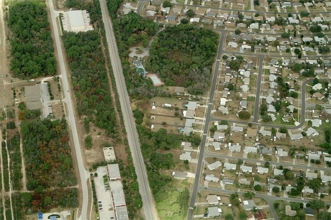
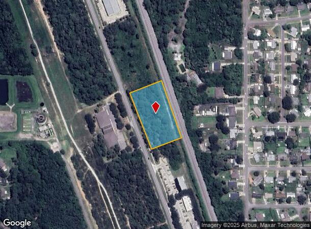
3810 Curtis Blvd
Palm Bay-Melbourne-Titusville, FL
Port St John Center
23-35-13-RT-0000B.0-0004.00
PORT ST JOHN CENTER BLOCK B LOT 4
Industrialacreage
Brevard
X
Florida
12009C0310H
4
2024
2.09 AC
2025
Brevard County
062108
Orlando
DEMOGRAPHICS near 3810 Curtis Blvd
1 Mile
3 Mile
5 Mile
2024 Total Population
6,992
24,152
40,862
2029 Population
7,552
26,164
44,351
Pop Growth 2024-2029
+ 8.01%
+ 8.33%
+ 8.54%
Average Age
42
42
43
2024 Total Households
2,849
9,534
16,153
HH Growth 2024-2029
+ 7.90%
+ 8.20%
+ 8.38%
Median Household Inc
$64,661
$71,011
$76,476
Avg Household Size
2.30
2.40
2.40
2024 Avg HH Vehicles
2.00
2.00
2.00
Median Home Value
$203,458
$220,812
$243,455
Median Year Built
1984
1987
1987
Nearby Places
Map Layers
Map Styles
 Street
 Aerial
- Restaurants
- Banks
- Shops
- Fitness
- Groceries
PUBLIC TRANSPORTATION
AIRPORT
Melbourne Orlando International
DRIVE
WALK
Distance
Melbourne Orlando International
50 min
35.7 mi
Orlando International
DRIVE
WALK
Distance
Orlando International
51 min
38.3 mi
Orlando Sanford International
DRIVE
WALK
Distance
Orlando Sanford International
67 min
46.2 mi
Freight Ports
Port Canaveral
DRIVE
WALK
Distance
Port Canaveral
24 min
15.2 mi
SALE & LEASE HISTORY
LISTING DATE
SALE/LEASE

Oct 21, 2016
For Sale
Nearby Properties
Address
Land Use
TOTAL SIZE
Lot Size
Zoning
Address
Land Use
TOTAL SIZE
Lot Size
Zoning
413,008 SF
127.62 AC
GMLH
Address
Land Use
TOTAL SIZE
Lot Size
Zoning
438,322 SF
148 AC
GML
Address
Land Use
TOTAL SIZE
Lot Size
Zoning
248,110 SF
12.77 AC
Address
Land Use
TOTAL SIZE
Lot Size
Zoning
203,226 SF
511.04 AC
P
Address
Land Use
TOTAL SIZE
Lot Size
Zoning
105,543 SF
16.08 AC
RU19
Address
Land Use
TOTAL SIZE
Lot Size
Zoning
73,476 SF
31.58 AC
BU1
Address
Land Use
TOTAL SIZE
Lot Size
Zoning
72,664 SF
6.44 AC
PID
Address
Land Use
TOTAL SIZE
Lot Size
Zoning
141,221 SF
85 AC
IU
Address
Land Use
TOTAL SIZE
Lot Size
Zoning
96,436 SF
19.10 AC
RU19
Address
Land Use
TOTAL SIZE
Lot Size
Zoning
48,555 SF
42.28 AC
IU
Address
Land Use
TOTAL SIZE
Lot Size
Zoning
63,083 SF
18.93 AC
GU
Address
Land Use
TOTAL SIZE
Lot Size
Zoning
65,645 SF
107.50 AC
GML
Address
Land Use
TOTAL SIZE
Lot Size
Zoning
89,772 SF
10.12 AC
BU1
Address
Land Use
TOTAL SIZE
Lot Size
Zoning
83,661 SF
15.08 AC
PID
Address
Land Use
TOTAL SIZE
Lot Size
Zoning
92,647 SF
7.02 AC
BU-2
Address
Land Use
TOTAL SIZE
Lot Size
Zoning
42,936 SF
27.69 AC
GU
Address
Land Use
TOTAL SIZE
Lot Size
Zoning
59,557 SF
7.28 AC
BU1
Address
Land Use
TOTAL SIZE
Lot Size
Zoning
73,134 SF
9 AC
PIP
Address
Land Use
TOTAL SIZE
Lot Size
Zoning
24,151 SF
4.62 AC
GML-H
Address
Land Use
TOTAL SIZE
Lot Size
Zoning
21,820 SF
4.32 AC
BU1
Address
Land Use
TOTAL SIZE
Lot Size
Zoning
20,168 SF
17.98 AC
AU
Address
Land Use
TOTAL SIZE
Lot Size
Zoning
85,132 SF
13.62 AC
IU
Address
Land Use
TOTAL SIZE
Lot Size
Zoning
60,075 SF
3.55 AC
P
Address
Land Use
TOTAL SIZE
Lot Size
Zoning
36,712 SF
1.80 AC
BU1
Address
Land Use
TOTAL SIZE
Lot Size
Zoning
180.58 AC
IU
Address
Land Use
TOTAL SIZE
Lot Size
Zoning
184.43 AC
IU
Address
Land Use
TOTAL SIZE
Lot Size
Zoning
15,873 SF
2.02 AC
BU-1
Address
Land Use
TOTAL SIZE
Lot Size
Zoning
39,430 SF
2.09 AC
Address
Land Use
TOTAL SIZE
Lot Size
Zoning
7,454 SF
24.95 AC
GML
Address
Land Use
TOTAL SIZE
Lot Size
Zoning
16,014 SF
1.62 AC
BU1
The World's #1 Commercial Real Estate Marketplace
Connect with us
© 2026 CoStar Group
The information above has been obtained from sources believed reliable. While we do not doubt its accuracy we have not verified it and make no guarantee, warranty or representation about it. It is your responsibility to independently confirm its accuracy and completeness. Any projections, opinions, assumptions, or estimates used are for example only and do not represent the current or future performance of the property. The value of this transaction to you depends on tax and other factors which should be evaluated by your tax, financial, and legal advisors. You and your advisors should conduct a careful, independent investigation of the property to determine to your satisfaction the suitability of the property for your needs.