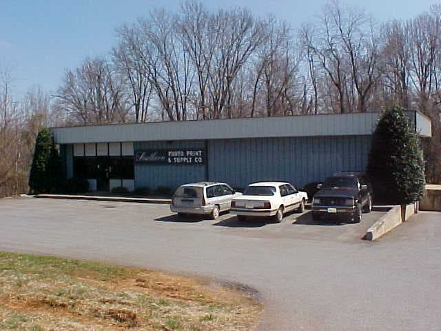
Property Record
3815 Old Forest Rd, Lynchburg, VA 24501
NEARBY LISTINGS FOR SALE OR LEASE
Property Detail
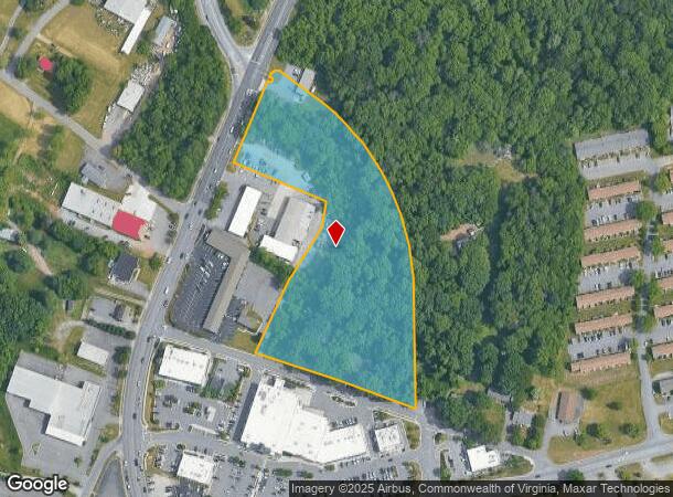
3815 Old Forest Rd
Lynchburg, VA
Old Forest Rd Commercial Corri
226-06-003
SCOTT PAYNE, NEW PARCEL B
Municipalproperty
Lynchburg City
X
Virginia
51009C0390C
5
0
6.16 AC
2025
Lynchburg
001400
Other Market Areas
2,100 SF
DEMOGRAPHICS near 3815 Old Forest Rd
1 Mile
3 Mile
5 Mile
2024 Total Population
4,384
39,411
92,469
2029 Population
4,366
39,617
93,221
Pop Growth 2024-2029
(0.41%)
+ 0.52%
+ 0.81%
Average Age
34
37
37
2024 Total Households
1,961
16,174
37,955
HH Growth 2024-2029
(0.41%)
+ 0.50%
+ 0.80%
Median Household Inc
$56,375
$63,212
$60,529
Avg Household Size
2.20
2.20
2.30
2024 Avg HH Vehicles
2.00
2.00
2.00
Median Home Value
$177,389
$194,528
$204,478
Median Year Built
1976
1974
1974
Nearby Places
Map Layers
Map Styles
 Street
 Aerial
- Restaurants
- Banks
- Shops
- Fitness
- Groceries
PUBLIC TRANSPORTATION
COMMUTER RAIL
Lynchburg (Crescent - Amtrak, Northeast Regional - Amtrak)
DRIVE
WALK
Distance
Lynchburg (Crescent - Amtrak, Northeast Regional - Amtrak)
8 min
4.0 mi
AIRPORT
Lynchburg Regional/Preston Glenn Field
DRIVE
WALK
Distance
Lynchburg Regional/Preston Glenn Field
13 min
6.6 mi
Freight Ports
Virginia Port Authority - Richmond
DRIVE
WALK
Distance
Virginia Port Authority - Richmond
157 min
116.4 mi
Nearby Properties
Address
Land Use
TOTAL SIZE
Lot Size
Zoning
Address
Land Use
TOTAL SIZE
Lot Size
Zoning
814,428 SF
99.03 AC
212923
Address
Land Use
TOTAL SIZE
Lot Size
Zoning
16,566 SF
Address
Land Use
TOTAL SIZE
Lot Size
Zoning
3.33 AC
1909
Address
Land Use
TOTAL SIZE
Lot Size
Zoning
326,293 SF
80.06 AC
R1R3
Address
Land Use
TOTAL SIZE
Lot Size
Zoning
1,282 SF
12.75 AC
Address
Land Use
TOTAL SIZE
Lot Size
Zoning
207,379 SF
10.24 AC
250905
Address
Land Use
TOTAL SIZE
Lot Size
Zoning
8,259 SF
13.02 AC
Address
Land Use
TOTAL SIZE
Lot Size
Zoning
181,808 SF
39.61 AC
192921
Address
Land Use
TOTAL SIZE
Lot Size
Zoning
86,855 SF
10.68 AC
B1
Address
Land Use
TOTAL SIZE
Lot Size
Zoning
1,241 SF
7.20 AC
2519
Address
Land Use
TOTAL SIZE
Lot Size
Zoning
415,272 SF
117.43 AC
I3RC
Address
Land Use
TOTAL SIZE
Lot Size
Zoning
10.13 AC
R4RC
Address
Land Use
TOTAL SIZE
Lot Size
Zoning
68,240 SF
20.56 AC
R4
Address
Land Use
TOTAL SIZE
Lot Size
Zoning
161,688 SF
16.57 AC
R3RC
Address
Land Use
TOTAL SIZE
Lot Size
Zoning
222,427 SF
23.56 AC
I2RC
Address
Land Use
TOTAL SIZE
Lot Size
Zoning
103,515 SF
25.04 AC
B5R1
Address
Land Use
TOTAL SIZE
Lot Size
Zoning
91,070 SF
9.80 AC
B3
Address
Land Use
TOTAL SIZE
Lot Size
Zoning
537,608 SF
47.65 AC
152919
Address
Land Use
TOTAL SIZE
Lot Size
Zoning
10.84 AC
R4RC
Address
Land Use
TOTAL SIZE
Lot Size
Zoning
94,608 SF
57.36 AC
2523
Address
Land Use
TOTAL SIZE
Lot Size
Zoning
343,261 SF
11.45 AC
130527
Address
Land Use
TOTAL SIZE
Lot Size
Zoning
8.29 AC
R3
Address
Land Use
TOTAL SIZE
Lot Size
Zoning
65,062 SF
6.39 AC
B5
Address
Land Use
TOTAL SIZE
Lot Size
Zoning
186,273 SF
35 AC
R1RC
Address
Land Use
TOTAL SIZE
Lot Size
Zoning
185,130 SF
32.87 AC
B3
Address
Land Use
TOTAL SIZE
Lot Size
Zoning
151,200 SF
24.18 AC
I1
Address
Land Use
TOTAL SIZE
Lot Size
Zoning
161,333 SF
10.60 AC
2119
Address
Land Use
TOTAL SIZE
Lot Size
Zoning
33,027 SF
15.02 AC
B5
Address
Land Use
TOTAL SIZE
Lot Size
Zoning
143,154 SF
15.37 AC
R5RC
Address
Land Use
TOTAL SIZE
Lot Size
Zoning
47,505 SF
9.32 AC
I1
The World's #1 Commercial Real Estate Marketplace
Connect with us
© 2025 CoStar Group
The information above has been obtained from sources believed reliable. While we do not doubt its accuracy we have not verified it and make no guarantee, warranty or representation about it. It is your responsibility to independently confirm its accuracy and completeness. Any projections, opinions, assumptions, or estimates used are for example only and do not represent the current or future performance of the property. The value of this transaction to you depends on tax and other factors which should be evaluated by your tax, financial, and legal advisors. You and your advisors should conduct a careful, independent investigation of the property to determine to your satisfaction the suitability of the property for your needs.