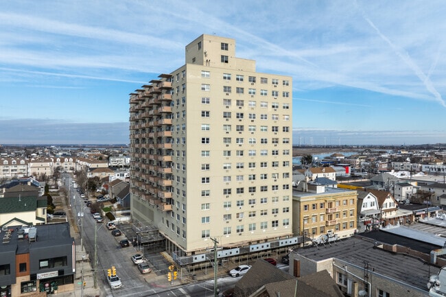
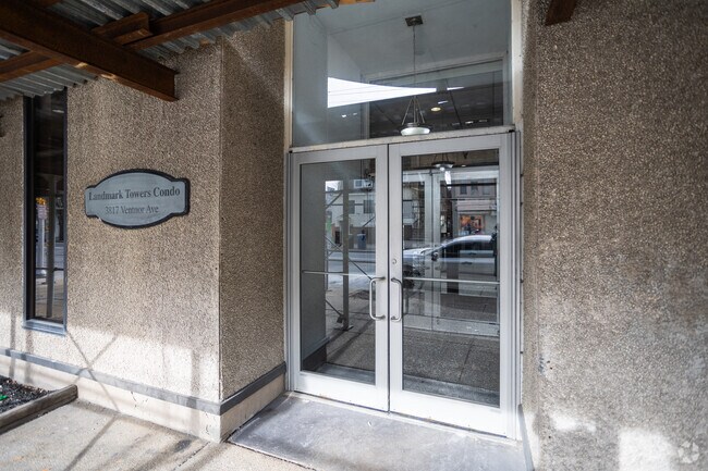
Property Record
3817 Ventnor Ave, Atlantic City, NJ 08401
NEARBY LISTINGS FOR SALE OR LEASE
Property Detail
3817 Ventnor Ave
Atlantic City-Hammonton, NJ
Landmark Towers Condo
02 00236-0000-00023
FACILITY NAME: COMMON ELEMENT
Taxexempt
Atlantic
ARE
New Jersey
34001C0452F
23
0
0.46 AC
2025
Lower Chelsea
000300
Philadelphia
DEMOGRAPHICS near 3817 Ventnor Ave
1 Mile
3 Mile
5 Mile
2024 Total Population
21,922
58,693
89,244
2029 Population
22,287
60,107
92,091
Pop Growth 2024-2029
+ 1.66%
+ 2.41%
+ 3.19%
Average Age
40
42
43
2024 Total Households
8,359
25,060
38,144
HH Growth 2024-2029
+ 2.24%
+ 2.50%
+ 3.64%
Median Household Inc
$41,498
$42,052
$49,840
Avg Household Size
2.40
2.20
2.20
2024 Avg HH Vehicles
1.00
1.00
1.00
Median Home Value
$205,629
$271,683
$303,253
Median Year Built
1950
1962
1964
Nearby Places
Map Layers
Map Styles
 Street
 Aerial
- Restaurants
- Banks
- Shops
- Fitness
- Groceries
PUBLIC TRANSPORTATION
COMMUTER RAIL
Atlantic City (Atlantic City Line - NJ Transit Commuter Rail (NJ Transit))
DRIVE
WALK
Distance
Atlantic City (Atlantic City Line - NJ Transit Commuter Rail (NJ Transit))
7 min
2.3 mi
Absecon (Atlantic City Line - NJ Transit Commuter Rail (NJ Transit))
DRIVE
WALK
Distance
Absecon (Atlantic City Line - NJ Transit Commuter Rail (NJ Transit))
14 min
7.1 mi
AIRPORT
Atlantic City International
DRIVE
WALK
Distance
Atlantic City International
41 min
15.4 mi
SALE & LEASE HISTORY
LISTING DATE
SALE/LEASE

Sep 14, 2017
For Sale
Nearby Properties
Address
Land Use
TOTAL SIZE
Lot Size
Zoning
Address
Land Use
TOTAL SIZE
Lot Size
Zoning
25.97 AC
HNRA
Address
Land Use
TOTAL SIZE
Lot Size
Zoning
Address
Land Use
TOTAL SIZE
Lot Size
Zoning
2,497,916 SF
6.96 AC
CBD
Address
Land Use
TOTAL SIZE
Lot Size
Zoning
6.20 AC
RS-C
Address
Land Use
TOTAL SIZE
Lot Size
Zoning
11.04 AC
HNRA
Address
Land Use
TOTAL SIZE
Lot Size
Zoning
5,364 SF
142.55 AC
BFRA
Address
Land Use
TOTAL SIZE
Lot Size
Zoning
14.73 AC
RVRA
Address
Land Use
TOTAL SIZE
Lot Size
Zoning
14.71 AC
RS-C
Address
Land Use
TOTAL SIZE
Lot Size
Zoning
69.16 AC
HNRA
Address
Land Use
TOTAL SIZE
Lot Size
Zoning
398,702 SF
4.05 AC
RS-C
Address
Land Use
TOTAL SIZE
Lot Size
Zoning
9.90 AC
RS-C
Address
Land Use
TOTAL SIZE
Lot Size
Zoning
6,552 SF
3.61 AC
RS
Address
Land Use
TOTAL SIZE
Lot Size
Zoning
3.54 AC
HNRA
Address
Land Use
TOTAL SIZE
Lot Size
Zoning
387,249 SF
49.56 AC
HW-C
Address
Land Use
TOTAL SIZE
Lot Size
Zoning
4.33 AC
RS-C
Address
Land Use
TOTAL SIZE
Lot Size
Zoning
Address
Land Use
TOTAL SIZE
Lot Size
Zoning
1.98 AC
RS-C
Address
Land Use
TOTAL SIZE
Lot Size
Zoning
0.78 AC
RS-C
Address
Land Use
TOTAL SIZE
Lot Size
Zoning
2.44 AC
RS-C
Address
Land Use
TOTAL SIZE
Lot Size
Zoning
7.63 AC
RS-C
Address
Land Use
TOTAL SIZE
Lot Size
Zoning
3.01 AC
RS-C
Address
Land Use
TOTAL SIZE
Lot Size
Zoning
2.81 AC
RS-C
Address
Land Use
TOTAL SIZE
Lot Size
Zoning
192,602 SF
5.80 AC
RS-C
Address
Land Use
TOTAL SIZE
Lot Size
Zoning
277,716 SF
5.45 AC
RS-C
Address
Land Use
TOTAL SIZE
Lot Size
Zoning
1.09 AC
RS-C
Address
Land Use
TOTAL SIZE
Lot Size
Zoning
28,520 SF
47.40 AC
M-C
Address
Land Use
TOTAL SIZE
Lot Size
Zoning
2.13 AC
RS-C
Address
Land Use
TOTAL SIZE
Lot Size
Zoning
2.75 AC
Address
Land Use
TOTAL SIZE
Lot Size
Zoning
2.91 AC
RS-C
Address
Land Use
TOTAL SIZE
Lot Size
Zoning
20.25 AC
06
The World's #1 Commercial Real Estate Marketplace
Connect with us
© 2025 CoStar Group
The information above has been obtained from sources believed reliable. While we do not doubt its accuracy we have not verified it and make no guarantee, warranty or representation about it. It is your responsibility to independently confirm its accuracy and completeness. Any projections, opinions, assumptions, or estimates used are for example only and do not represent the current or future performance of the property. The value of this transaction to you depends on tax and other factors which should be evaluated by your tax, financial, and legal advisors. You and your advisors should conduct a careful, independent investigation of the property to determine to your satisfaction the suitability of the property for your needs.