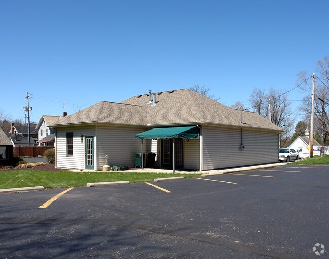
Property Record
3818 Mogadore Rd, Mogadore, OH 44260


NEARBY LISTINGS FOR SALE OR LEASE
Property Detail
3818 Mogadore Rd
Akron, OH
Curtis Fentons 04 Allotment
55-01563
TR 8 LOT12 S OF MOGADORE RD & CURTIS FENTON # 4 LOTS 47 & 48 ALL
Officebuilding
Summit
X
Ohio
39153C0220F
48
2023
0.27 AC
2025
Akron
531001
Cleveland
1,871 SF
DEMOGRAPHICS near 3818 Mogadore Rd
1 mile
3 mile
5 mile
2024 Total Population
4,847
34,651
92,203
2029 Population
4,803
34,296
91,519
Pop Growth 2024-2029
(0.91%)
(1.02%)
(0.74%)
Average Age
42
43
42
2024 Total Households
1,954
15,054
39,257
HH Growth 2024-2029
(0.97%)
(1.08%)
(0.82%)
Median Household Inc
$68,283
$58,752
$58,578
Avg Household Size
2.50
2.30
2.30
2024 Avg HH Vehicles
2.00
2.00
2.00
Median Home Value
$155,403
$148,112
$148,233
Median Year Built
1959
1961
1962
Nearby Places
Map Layers
Map Styles
 Street
 Aerial
Transit
 Traffic
 Biking
Places
Listings with unknown addresses are not visible on the map
- Restaurants
- Banks
- Shops
- Fitness
- Groceries
PUBLIC TRANSPORTATION
COMMUTER RAIL
Drive
Walk
Distance
16 min
8.4 mi
AIRPORT
Akron-Canton Regional
Drive
Walk
Distance
Akron-Canton Regional
25 min
12.8 mi
Cleveland-Hopkins International
Drive
Walk
Distance
Cleveland-Hopkins International
67 min
47.6 mi
Nearby Properties
Address
Land Use
TOTAL SIZE
Lot Size
Zoning
Address
Land Use
TOTAL SIZE
Lot Size
Zoning
162,774 SF
16.58 AC
Address
Land Use
TOTAL SIZE
Lot Size
Zoning
264,753 SF
22.87 AC
Address
Land Use
TOTAL SIZE
Lot Size
Zoning
Address
Land Use
TOTAL SIZE
Lot Size
Zoning
145,684 SF
27.98 AC
Address
Land Use
TOTAL SIZE
Lot Size
Zoning
115,586 SF
4.93 AC
Address
Land Use
TOTAL SIZE
Lot Size
Zoning
374,370 SF
27.79 AC
Address
Land Use
TOTAL SIZE
Lot Size
Zoning
168,889 SF
30.80 AC
Address
Land Use
TOTAL SIZE
Lot Size
Zoning
56,529 SF
3.67 AC
Address
Land Use
TOTAL SIZE
Lot Size
Zoning
489,909 SF
23.77 AC
Address
Land Use
TOTAL SIZE
Lot Size
Zoning
882,093 SF
50.96 AC
Address
Land Use
TOTAL SIZE
Lot Size
Zoning
124,939 SF
13.89 AC
Address
Land Use
TOTAL SIZE
Lot Size
Zoning
667,050 SF
24.55 AC
Address
Land Use
TOTAL SIZE
Lot Size
Zoning
55,072 SF
3.41 AC
Address
Land Use
TOTAL SIZE
Lot Size
Zoning
97,454 SF
3.14 AC
Address
Land Use
TOTAL SIZE
Lot Size
Zoning
141,342 SF
6.34 AC
Address
Land Use
TOTAL SIZE
Lot Size
Zoning
329,075 SF
14.11 AC
Address
Land Use
TOTAL SIZE
Lot Size
Zoning
291,490 SF
14 AC
Address
Land Use
TOTAL SIZE
Lot Size
Zoning
212,724 SF
17.99 AC
Address
Land Use
TOTAL SIZE
Lot Size
Zoning
76,000 SF
4 AC
Address
Land Use
TOTAL SIZE
Lot Size
Zoning
248,589 SF
25.31 AC
Address
Land Use
TOTAL SIZE
Lot Size
Zoning
328,600 SF
19.36 AC
Address
Land Use
TOTAL SIZE
Lot Size
Zoning
22,309 SF
0.72 AC
Address
Land Use
TOTAL SIZE
Lot Size
Zoning
Address
Land Use
TOTAL SIZE
Lot Size
Zoning
410,743 SF
59.26 AC
Address
Land Use
TOTAL SIZE
Lot Size
Zoning
273,024 SF
14 AC
Address
Land Use
TOTAL SIZE
Lot Size
Zoning
46,540 SF
7.03 AC
Address
Land Use
TOTAL SIZE
Lot Size
Zoning
120,480 SF
5.45 AC
Address
Land Use
TOTAL SIZE
Lot Size
Zoning
353,162 SF
9.67 AC
Address
Land Use
TOTAL SIZE
Lot Size
Zoning
60,721 SF
7.46 AC
Address
Land Use
TOTAL SIZE
Lot Size
Zoning
50,120 SF
4.09 AC
The World's #1 Commercial Real Estate Marketplace
Connect with us
© 2026 CoStar Group
The information above has been obtained from sources believed reliable. While we do not doubt its accuracy we have not verified it and make no guarantee, warranty or representation about it. It is your responsibility to independently confirm its accuracy and completeness. Any projections, opinions, assumptions, or estimates used are for example only and do not represent the current or future performance of the property. The value of this transaction to you depends on tax and other factors which should be evaluated by your tax, financial, and legal advisors. You and your advisors should conduct a careful, independent investigation of the property to determine to your satisfaction the suitability of the property for your needs.