Property Record
382 E Hood Ave, Sisters, OR 97759
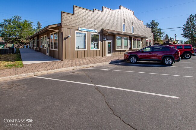

Property Detail
382 E Hood Ave
134670
DAVIDSON ADDITION TO SISTERS BLOCK 3 LOT 11
Commercialnec
Deschutes
DC
Oregon
B and X Area of moderate flood hazard, usually the area between the limits of the 100-year and 500-year floods.
11
2025
0.16 AC
2025
Deschutes County
000502
Portland
7,200 SF
Bend, OR
NEARBY LISTINGS FOR SALE OR LEASE
DEMOGRAPHICS near 382 E Hood Ave
1 mile
3 mile
5 mile
2025 Total Population
3,409
6,776
8,668
2030 Population
3,589
7,201
9,195
Pop Growth 2025-2030
+ 5.28%
+ 6.27%
+ 6.08%
Average Age
45
48
49
2025 Total Households
1,475
2,910
3,697
HH Growth 2025-2030
+ 5.36%
+ 6.29%
+ 6.11%
Median Household Inc
$100,927
$101,504
$105,059
Avg Household Size
2.30
2.30
2.30
2025 Avg HH Vehicles
2.00
2.00
2.00
Median Home Value
$715,986
$765,579
$787,614
Median Year Built
2003
2001
2000
Nearby Places
Map Layers
Map Styles
 Street
 Aerial
Layers
 Traffic
 Biking
Places
Listings with unknown addresses are not visible on the map
- Restaurants
- Banks
- Shops
- Fitness
- Groceries
PUBLIC TRANSPORTATION
AIRPORT
Roberts Field
Drive
Walk
Distance
Roberts Field
32 min
20.9 mi
Freight Ports
Port of Portland
Drive
Walk
Distance
Port of Portland
202 min
156.3 mi
SALE & LEASE HISTORY
LISTING DATE
SALE/LEASE

Sep 24, 2024
For Lease
May 16, 2021
For Sale
Mar 27, 2019
For Lease
Mar 26, 2023
For Sale
Jan 31, 2025
For Lease
Jan 13, 2020
For Lease
Dec 28, 2020
For Sale
Nearby Properties
Address
Land Use
TOTAL SIZE
Lot Size
Zoning
Address
Land Use
TOTAL SIZE
Lot Size
Zoning
64,450 SF
5.27 AC
DC
Address
Land Use
TOTAL SIZE
Lot Size
Zoning
67,150 SF
5.82 AC
HC
Address
Land Use
TOTAL SIZE
Lot Size
Zoning
48,784 SF
11.57 AC
PF
Address
Land Use
TOTAL SIZE
Lot Size
Zoning
7.67 AC
HC
Address
Land Use
TOTAL SIZE
Lot Size
Zoning
47,248 SF
7.67 AC
HC
Address
Land Use
TOTAL SIZE
Lot Size
Zoning
1,822 SF
2.61 AC
Address
Land Use
TOTAL SIZE
Lot Size
Zoning
1,800 SF
3.03 AC
MFR
Address
Land Use
TOTAL SIZE
Lot Size
Zoning
51,356 SF
5.01 AC
HC
Address
Land Use
TOTAL SIZE
Lot Size
Zoning
35,227 SF
4.98 AC
HC
Address
Land Use
TOTAL SIZE
Lot Size
Zoning
4,477.70 AC
F1
Address
Land Use
TOTAL SIZE
Lot Size
Zoning
4,477.70 AC
F1
Address
Land Use
TOTAL SIZE
Lot Size
Zoning
4,477.70 AC
F1
Address
Land Use
TOTAL SIZE
Lot Size
Zoning
39,856 SF
2.09 AC
MFR
Address
Land Use
TOTAL SIZE
Lot Size
Zoning
28,696 SF
1.41 AC
MFR
Address
Land Use
TOTAL SIZE
Lot Size
Zoning
16,759 SF
1.40 AC
HC
Address
Land Use
TOTAL SIZE
Lot Size
Zoning
40,880 SF
2.51 AC
Address
Land Use
TOTAL SIZE
Lot Size
Zoning
23,760 SF
1.13 AC
HC
Address
Land Use
TOTAL SIZE
Lot Size
Zoning
9,056 SF
1.34 AC
HC
Address
Land Use
TOTAL SIZE
Lot Size
Zoning
55,514 SF
2.19 AC
LI
Address
Land Use
TOTAL SIZE
Lot Size
Zoning
2.19 AC
LI
Address
Land Use
TOTAL SIZE
Lot Size
Zoning
150.32 AC
F1
Address
Land Use
TOTAL SIZE
Lot Size
Zoning
150.32 AC
F1
Address
Land Use
TOTAL SIZE
Lot Size
Zoning
5,961 SF
0.78 AC
MFR
Address
Land Use
TOTAL SIZE
Lot Size
Zoning
32,460 SF
2.73 AC
LI
Address
Land Use
TOTAL SIZE
Lot Size
Zoning
8,962 SF
0.82 AC
PF
Address
Land Use
TOTAL SIZE
Lot Size
Zoning
3,280 SF
0.98 AC
MFR
Address
Land Use
TOTAL SIZE
Lot Size
Zoning
300 SF
2.04 AC
Address
Land Use
TOTAL SIZE
Lot Size
Zoning
32,972 SF
1.31 AC
HC
Address
Land Use
TOTAL SIZE
Lot Size
Zoning
22,161 SF
0.67 AC
NSBP
Address
Land Use
TOTAL SIZE
Lot Size
Zoning
0.67 AC
NSBP
The World's #1 Commercial Real Estate Marketplace
Connect with us
© 2026 CoStar Group
The information above has been obtained from sources believed reliable. While we do not doubt its accuracy we have not verified it and make no guarantee, warranty or representation about it. It is your responsibility to independently confirm its accuracy and completeness. Any projections, opinions, assumptions, or estimates used are for example only and do not represent the current or future performance of the property. The value of this transaction to you depends on tax and other factors which should be evaluated by your tax, financial, and legal advisors. You and your advisors should conduct a careful, independent investigation of the property to determine to your satisfaction the suitability of the property for your needs.