Property Record
3820 Wards Rd, Lynchburg, VA 24502
NEARBY LISTINGS FOR SALE OR LEASE
Property Detail
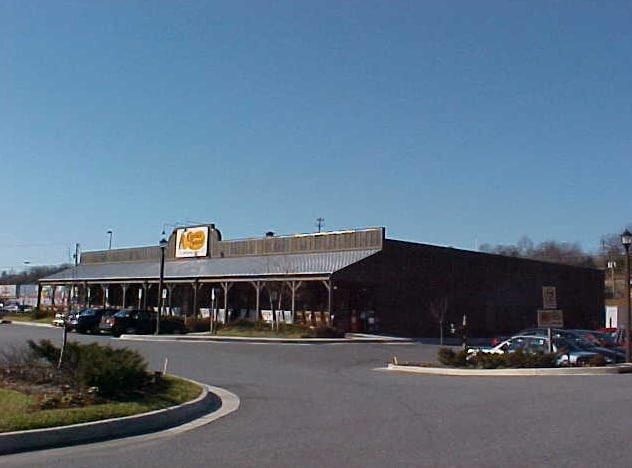
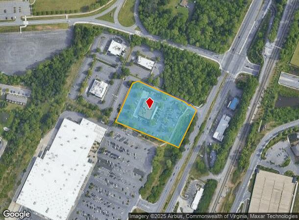
3820 Wards Rd
Lynchburg, VA
Wards Rd Commercial Corridor
257-03-017
ROCKY BOTTOM REALTY LOT 1
Restaurantbuilding
Lynchburg City
AE
Virginia
51019C0400D
1
2025
2.84 AC
2025
Lynchburg
001601
Other Market Areas
10,062 SF
DEMOGRAPHICS near 3820 Wards Rd
1 Mile
3 Mile
5 Mile
2024 Total Population
2,445
32,960
85,220
2029 Population
2,469
33,113
85,582
Pop Growth 2024-2029
+ 0.98%
+ 0.46%
+ 0.42%
Average Age
33
36
37
2024 Total Households
806
13,248
35,111
HH Growth 2024-2029
+ 1.12%
+ 0.49%
+ 0.44%
Median Household Inc
$42,999
$55,821
$53,474
Avg Household Size
2.30
2.20
2.20
2024 Avg HH Vehicles
2.00
2.00
2.00
Median Home Value
$177,336
$166,988
$173,519
Median Year Built
1979
1977
1975
Nearby Places
Map Layers
Map Styles
 Street
 Aerial
- Restaurants
- Banks
- Shops
- Fitness
- Groceries
PUBLIC TRANSPORTATION
COMMUTER RAIL
DRIVE
WALK
Distance
10 min
5.1 mi
AIRPORT
Lynchburg Regional/Preston Glenn Field
DRIVE
WALK
Distance
Lynchburg Regional/Preston Glenn Field
9 min
3.2 mi
Nearby Properties
Address
Land Use
TOTAL SIZE
Lot Size
Zoning
Address
Land Use
TOTAL SIZE
Lot Size
Zoning
1,116,411 SF
186.88 AC
B5
Address
Land Use
TOTAL SIZE
Lot Size
Zoning
816,228 SF
54.13 AC
B5I2
Address
Land Use
TOTAL SIZE
Lot Size
Zoning
353,180 SF
22.86 AC
B3
Address
Land Use
TOTAL SIZE
Lot Size
Zoning
22.70 AC
Address
Land Use
TOTAL SIZE
Lot Size
Zoning
912 SF
52.88 AC
BGC
Address
Land Use
TOTAL SIZE
Lot Size
Zoning
400,209 SF
26.87 AC
B5
Address
Land Use
TOTAL SIZE
Lot Size
Zoning
326,293 SF
80.06 AC
R1R3
Address
Land Use
TOTAL SIZE
Lot Size
Zoning
1,282 SF
12.75 AC
Address
Land Use
TOTAL SIZE
Lot Size
Zoning
Address
Land Use
TOTAL SIZE
Lot Size
Zoning
1,200 SF
73.13 AC
Address
Land Use
TOTAL SIZE
Lot Size
Zoning
207,379 SF
10.24 AC
250905
Address
Land Use
TOTAL SIZE
Lot Size
Zoning
4,672 SF
905.07 AC
BHC
Address
Land Use
TOTAL SIZE
Lot Size
Zoning
163,760 SF
12 AC
Address
Land Use
TOTAL SIZE
Lot Size
Zoning
199,056 SF
16.21 AC
R1
Address
Land Use
TOTAL SIZE
Lot Size
Zoning
17,210 SF
14.35 AC
Address
Land Use
TOTAL SIZE
Lot Size
Zoning
8,259 SF
13.02 AC
Address
Land Use
TOTAL SIZE
Lot Size
Zoning
181,808 SF
39.61 AC
192921
Address
Land Use
TOTAL SIZE
Lot Size
Zoning
221,676 SF
102.07 AC
231529
Address
Land Use
TOTAL SIZE
Lot Size
Zoning
387,080 SF
18.30 AC
1509
Address
Land Use
TOTAL SIZE
Lot Size
Zoning
Address
Land Use
TOTAL SIZE
Lot Size
Zoning
284,151 SF
70.13 AC
I3
Address
Land Use
TOTAL SIZE
Lot Size
Zoning
1,241 SF
7.20 AC
2519
Address
Land Use
TOTAL SIZE
Lot Size
Zoning
267,447 SF
28.46 AC
B3
Address
Land Use
TOTAL SIZE
Lot Size
Zoning
173,573 SF
8.80 AC
Address
Land Use
TOTAL SIZE
Lot Size
Zoning
222,427 SF
23.56 AC
I2RC
Address
Land Use
TOTAL SIZE
Lot Size
Zoning
290,213 SF
14.93 AC
I3
Address
Land Use
TOTAL SIZE
Lot Size
Zoning
88,286 SF
11.85 AC
Address
Land Use
TOTAL SIZE
Lot Size
Zoning
10.84 AC
R4RC
Address
Land Use
TOTAL SIZE
Lot Size
Zoning
8.29 AC
R3
Address
Land Use
TOTAL SIZE
Lot Size
Zoning
188,155 SF
18.49 AC
B3I2RC
The World's #1 Commercial Real Estate Marketplace
Connect with us
© 2025 CoStar Group
The information above has been obtained from sources believed reliable. While we do not doubt its accuracy we have not verified it and make no guarantee, warranty or representation about it. It is your responsibility to independently confirm its accuracy and completeness. Any projections, opinions, assumptions, or estimates used are for example only and do not represent the current or future performance of the property. The value of this transaction to you depends on tax and other factors which should be evaluated by your tax, financial, and legal advisors. You and your advisors should conduct a careful, independent investigation of the property to determine to your satisfaction the suitability of the property for your needs.