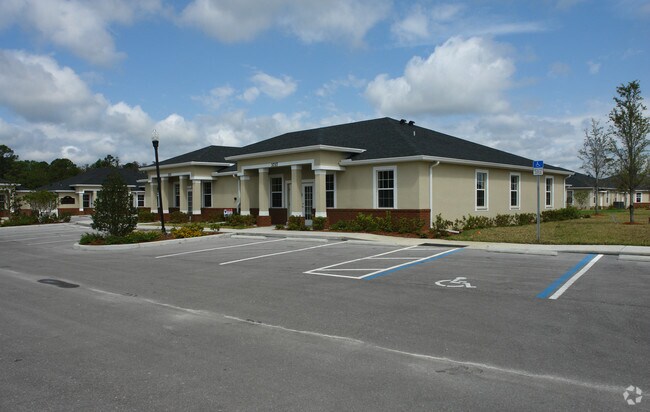
Property Record
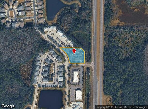
3820 Windcrest Dr, Wesley Chapel, FL 33544
NEARBY LISTINGS FOR SALE OR LEASE
Property Detail
3820 Windcrest Dr
Tampa-St. Petersburg-Clearwater, FL
Seven Oaks
24-26-19-0000-00100-0011
THAT PORTION OF THE NE1/4 DESC AS COM AT SE COR OF NE1/4 OF SEC 24 TH ALG SOUTH BDY OF SAID NE1/4 OF SEC S89DEG 56 45W 103.19 FT TO POINT ON WLY R/W LINE OF SR 581 TH ALG WLY R/W LINE OF SR 581 N00DEG 29 09E 1673.41 FT TH N89DEG 30 51W 100.00 FT FOR
Officebuilding
Pasco
X
Florida
12101C0428F
11
2024
1.25 AC
2025
Pasco County
032106
Tampa/St Petersburg
12,422 SF
DEMOGRAPHICS near 3820 Windcrest Dr
1 Mile
3 Mile
5 Mile
2024 Total Population
5,959
48,102
128,516
2029 Population
7,198
57,916
151,691
Pop Growth 2024-2029
+ 20.79%
+ 20.40%
+ 18.03%
Average Age
37
38
38
2024 Total Households
1,965
16,799
45,389
HH Growth 2024-2029
+ 20.81%
+ 20.34%
+ 18.02%
Median Household Inc
$139,056
$106,889
$100,468
Avg Household Size
3.00
2.80
2.80
2024 Avg HH Vehicles
2.00
2.00
2.00
Median Home Value
$435,888
$336,504
$321,058
Median Year Built
2010
2004
2004
Nearby Places
Map Layers
Map Styles
 Street
 Aerial
- Restaurants
- Banks
- Shops
- Fitness
- Groceries
PUBLIC TRANSPORTATION
AIRPORT
Tampa International
DRIVE
WALK
Distance
Tampa International
41 min
29.9 mi
St Pete-Clearwater International
DRIVE
WALK
Distance
St Pete-Clearwater International
58 min
39.1 mi
Freight Ports
Port of Tampa Bay
DRIVE
WALK
Distance
Port of Tampa Bay
37 min
25.6 mi
Nearby Properties
Address
Land Use
TOTAL SIZE
Lot Size
Zoning
Address
Land Use
TOTAL SIZE
Lot Size
Zoning
455,090 SF
52.24 AC
MPUD
Address
Land Use
TOTAL SIZE
Lot Size
Zoning
425,346 SF
19.60 AC
MPUD
Address
Land Use
TOTAL SIZE
Lot Size
Zoning
306,559 SF
34.59 AC
MPUD
Address
Land Use
TOTAL SIZE
Lot Size
Zoning
343,155 SF
23.92 AC
MPUD
Address
Land Use
TOTAL SIZE
Lot Size
Zoning
293,253 SF
51.11 AC
MPUD
Address
Land Use
TOTAL SIZE
Lot Size
Zoning
38,091 SF
43.42 AC
MPUD
Address
Land Use
TOTAL SIZE
Lot Size
Zoning
425,129 SF
12.72 AC
MPUD
Address
Land Use
TOTAL SIZE
Lot Size
Zoning
347,708 SF
43.40 AC
MPUD
Address
Land Use
TOTAL SIZE
Lot Size
Zoning
346,880 SF
20.01 AC
MPUD
Address
Land Use
TOTAL SIZE
Lot Size
Zoning
319,575 SF
19.80 AC
MPUD
Address
Land Use
TOTAL SIZE
Lot Size
Zoning
324,184 SF
19.12 AC
MPUD
Address
Land Use
TOTAL SIZE
Lot Size
Zoning
263,289 SF
26.30 AC
MPUD
Address
Land Use
TOTAL SIZE
Lot Size
Zoning
315,343 SF
20.80 AC
MPUD
Address
Land Use
TOTAL SIZE
Lot Size
Zoning
267,326 SF
22.50 AC
MPUD
Address
Land Use
TOTAL SIZE
Lot Size
Zoning
279,167 SF
14.75 AC
MPUD
Address
Land Use
TOTAL SIZE
Lot Size
Zoning
275,549 SF
16.24 AC
C2
Address
Land Use
TOTAL SIZE
Lot Size
Zoning
192,698 SF
19.31 AC
MPUD
Address
Land Use
TOTAL SIZE
Lot Size
Zoning
50,016 SF
14.04 AC
MPUD
Address
Land Use
TOTAL SIZE
Lot Size
Zoning
244,355 SF
70.12 AC
MPUD
Address
Land Use
TOTAL SIZE
Lot Size
Zoning
198,276 SF
60.64 AC
AC
Address
Land Use
TOTAL SIZE
Lot Size
Zoning
153,412 SF
9.77 AC
MPUD
Address
Land Use
TOTAL SIZE
Lot Size
Zoning
175,978 SF
29.19 AC
AC
Address
Land Use
TOTAL SIZE
Lot Size
Zoning
146,401 SF
17.78 AC
MPUD
Address
Land Use
TOTAL SIZE
Lot Size
Zoning
153,330 SF
16.99 AC
PUD
Address
Land Use
TOTAL SIZE
Lot Size
Zoning
147,238 SF
13.89 AC
MPUD
Address
Land Use
TOTAL SIZE
Lot Size
Zoning
121,727 SF
48.75 AC
MPUD
Address
Land Use
TOTAL SIZE
Lot Size
Zoning
136,319 SF
26.11 AC
MPUD
Address
Land Use
TOTAL SIZE
Lot Size
Zoning
115,596 SF
3.83 AC
C2
Address
Land Use
TOTAL SIZE
Lot Size
Zoning
106,926 SF
89.04 AC
MPUD
Address
Land Use
TOTAL SIZE
Lot Size
Zoning
83,294 SF
7.68 AC
MPUD
The World's #1 Commercial Real Estate Marketplace
Connect with us
© 2025 CoStar Group
The information above has been obtained from sources believed reliable. While we do not doubt its accuracy we have not verified it and make no guarantee, warranty or representation about it. It is your responsibility to independently confirm its accuracy and completeness. Any projections, opinions, assumptions, or estimates used are for example only and do not represent the current or future performance of the property. The value of this transaction to you depends on tax and other factors which should be evaluated by your tax, financial, and legal advisors. You and your advisors should conduct a careful, independent investigation of the property to determine to your satisfaction the suitability of the property for your needs.