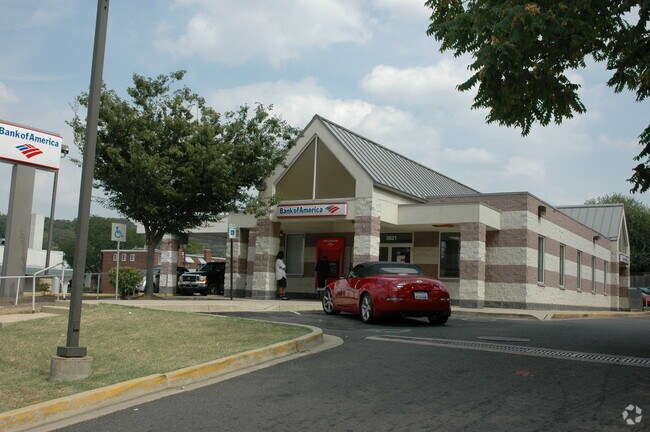
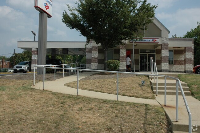
Property Record
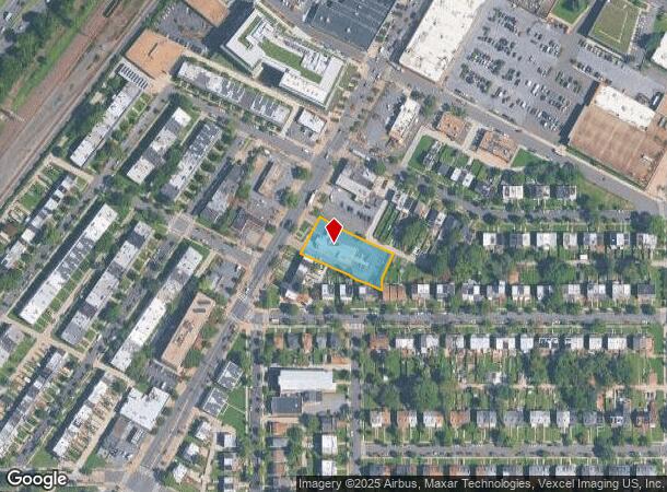
3821 Minnesota Ave Ne, Washington, DC 20019
NEARBY LISTINGS FOR SALE OR LEASE
Property Detail
3821 Minnesota Ave Ne
Washington-Arlington-Alexandria, DC-VA-MD-WV
Deanwood
5050-0080
SQUARE 5050 LOT 0080 NBHD: DEANWOOD
Financialbuilding
District of Columbia
X
District of Columbia
1100010039C
80
2025
0.58 AC
2025
Northeast
009603
Washington, DC
3,456 SF
DEMOGRAPHICS near 3821 Minnesota Ave Ne
1 Mile
3 Mile
5 Mile
2024 Total Population
26,766
226,268
628,987
2029 Population
24,440
210,626
591,483
Pop Growth 2024-2029
(8.69%)
(6.91%)
(5.96%)
Average Age
38
38
38
2024 Total Households
11,409
95,511
271,764
HH Growth 2024-2029
(9.61%)
(7.70%)
(6.74%)
Median Household Inc
$41,270
$71,240
$79,318
Avg Household Size
2.30
2.20
2.20
2024 Avg HH Vehicles
1.00
1.00
1.00
Median Home Value
$402,806
$464,535
$437,431
Median Year Built
1957
1956
1965
Nearby Places
Map Layers
Map Styles
 Street
 Aerial
- Restaurants
- Banks
- Shops
- Fitness
- Groceries
PUBLIC TRANSPORTATION
TRANSIT/SUBWAY
Minnesota Avenue (Orange Line - Washington Metropolitan Area Transit Authority Metrorail (Metrorail))
DRIVE
WALK
Distance
Minnesota Avenue (Orange Line - Washington Metropolitan Area Transit Authority Metrorail (Metrorail))
3 min
12 min
0.6 mi
Benning Road (Blue Line - Washington Metropolitan Area Transit Authority Metrorail (Metrorail), Silver Line - Washington Metropolitan Area Transit Authority Metrorail (Metrorail))
DRIVE
WALK
Distance
Benning Road (Blue Line - Washington Metropolitan Area Transit Authority Metrorail (Metrorail), Silver Line - Washington Metropolitan Area Transit Authority Metrorail (Metrorail))
2 min
17 min
0.9 mi
COMMUTER RAIL
DRIVE
WALK
Distance
6 min
3.4 mi
Union Station (Red Line - Washington Metropolitan Area Transit Authority Metrorail (Metrorail))
DRIVE
WALK
Distance
Union Station (Red Line - Washington Metropolitan Area Transit Authority Metrorail (Metrorail))
7 min
3.6 mi
AIRPORT
Ronald Reagan Washington Ntl
DRIVE
WALK
Distance
Ronald Reagan Washington Ntl
18 min
9.6 mi
Baltimore/Washington International Thurgood Marshall
DRIVE
WALK
Distance
Baltimore/Washington International Thurgood Marshall
42 min
28.2 mi
Washington Dulles International
DRIVE
WALK
Distance
Washington Dulles International
52 min
32.3 mi
Freight Ports
Port of Baltimore
DRIVE
WALK
Distance
Port of Baltimore
51 min
34.5 mi
Nearby Properties
Address
Land Use
TOTAL SIZE
Lot Size
Zoning
Address
Land Use
TOTAL SIZE
Lot Size
Zoning
58,289 SF
418.97 AC
MU-4;PDR-1
Address
Land Use
TOTAL SIZE
Lot Size
Zoning
2,542,436 SF
6.39 AC
MU-2;MU-4;
Address
Land Use
TOTAL SIZE
Lot Size
Zoning
1,642,951 SF
95.12 AC
RF-1
Address
Land Use
TOTAL SIZE
Lot Size
Zoning
1,323,000 SF
3.36 AC
RA-2
Address
Land Use
TOTAL SIZE
Lot Size
Zoning
21.28 AC
GOV
Address
Land Use
TOTAL SIZE
Lot Size
Zoning
169.85 AC
R-2;RA-1;U
Address
Land Use
TOTAL SIZE
Lot Size
Zoning
812,092 SF
10.19 AC
UNZONED
Address
Land Use
TOTAL SIZE
Lot Size
Zoning
726,490 SF
3.84 AC
RA-2
Address
Land Use
TOTAL SIZE
Lot Size
Zoning
572,916 SF
1.26 AC
UNZONED
Address
Land Use
TOTAL SIZE
Lot Size
Zoning
2,131,229 SF
144.34 AC
AG
Address
Land Use
TOTAL SIZE
Lot Size
Zoning
1,059,397 SF
2.51 AC
PDR-3;USN
Address
Land Use
TOTAL SIZE
Lot Size
Zoning
30,000 SF
819.17 AC
PDR-1;RA-1
Address
Land Use
TOTAL SIZE
Lot Size
Zoning
538,974 SF
1.26 AC
PDR-3
Address
Land Use
TOTAL SIZE
Lot Size
Zoning
755,499 SF
1.75 AC
PDR-3;USN
Address
Land Use
TOTAL SIZE
Lot Size
Zoning
418,531 SF
2.48 AC
RF-1
Address
Land Use
TOTAL SIZE
Lot Size
Zoning
407,850 SF
Address
Land Use
TOTAL SIZE
Lot Size
Zoning
36.52 AC
HE-2;HE-3;
Address
Land Use
TOTAL SIZE
Lot Size
Zoning
236,535 SF
12.54 AC
R-2
Address
Land Use
TOTAL SIZE
Lot Size
Zoning
747,331 SF
1.26 AC
PDR-3;USN
Address
Land Use
TOTAL SIZE
Lot Size
Zoning
368,602 SF
1.71 AC
MU-4;NMU-5
Address
Land Use
TOTAL SIZE
Lot Size
Zoning
338,258 SF
1.94 AC
PDR-1;PDR-
Address
Land Use
TOTAL SIZE
Lot Size
Zoning
281,204 SF
PDR-1;PDR-
Address
Land Use
TOTAL SIZE
Lot Size
Zoning
280,000 SF
1.55 AC
PDR-1
Address
Land Use
TOTAL SIZE
Lot Size
Zoning
190,000 SF
D-5
Address
Land Use
TOTAL SIZE
Lot Size
Zoning
449,882 SF
2.32 AC
NMU-5A/H-H
Address
Land Use
TOTAL SIZE
Lot Size
Zoning
176.56 AC
HE-3;UNZON
Address
Land Use
TOTAL SIZE
Lot Size
Zoning
546,573 SF
3.78 AC
UNZONED
Address
Land Use
TOTAL SIZE
Lot Size
Zoning
446,000 SF
PDR-1
Address
Land Use
TOTAL SIZE
Lot Size
Zoning
268,520 SF
PDR-1
Address
Land Use
TOTAL SIZE
Lot Size
Zoning
798,776 SF
2.55 AC
UNZONED
The World's #1 Commercial Real Estate Marketplace
Connect with us
© 2025 CoStar Group
The information above has been obtained from sources believed reliable. While we do not doubt its accuracy we have not verified it and make no guarantee, warranty or representation about it. It is your responsibility to independently confirm its accuracy and completeness. Any projections, opinions, assumptions, or estimates used are for example only and do not represent the current or future performance of the property. The value of this transaction to you depends on tax and other factors which should be evaluated by your tax, financial, and legal advisors. You and your advisors should conduct a careful, independent investigation of the property to determine to your satisfaction the suitability of the property for your needs.