Property Record
3822 E Parsons Point Rd, Hernando, FL 34442
NEARBY LISTINGS FOR SALE OR LEASE
-
-
View all Hernando listings for sale on LoopNet.com
Property Detail
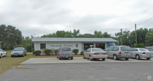
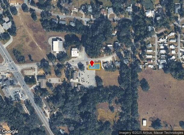
3822 E Parsons Point Rd
Homosassa Springs, FL
Bryants Lakeview Manor
19E-18S-26-0030-000E0-0010
BRYANTS LAKE VIEW MANOR PB 3 PG 121 LOT 1 BLK E
Storemultistory
Citrus
X
Florida
12017C0238D
1
2024
0.19 AC
2025
Florida Central North Area
450800
Other Market Areas
882 SF
DEMOGRAPHICS near 3822 E Parsons Point Rd
1 mile
3 mile
5 mile
2024 Total Population
1,510
13,138
35,413
2029 Population
1,731
14,958
40,370
Pop Growth 2024-2029
+ 14.64%
+ 13.85%
+ 14.00%
Average Age
51
50
52
2024 Total Households
703
5,938
16,250
HH Growth 2024-2029
+ 14.37%
+ 13.66%
+ 13.84%
Median Household Inc
$43,928
$45,779
$45,874
Avg Household Size
2.10
2.20
2.10
2024 Avg HH Vehicles
2.00
2.00
2.00
Median Home Value
$156,716
$179,598
$210,748
Median Year Built
1985
1991
1990
Nearby Places
Map Layers
Map Styles
 Street
 Aerial
Transit
 Traffic
 Biking
Places
Listings with unknown addresses are not visible on the map
- Restaurants
- Banks
- Shops
- Fitness
- Groceries
SALE & LEASE HISTORY
LISTING DATE
SALE/LEASE

Sep 06, 2023
For Sale
Nearby Properties
Address
Land Use
TOTAL SIZE
Lot Size
Zoning
Address
Land Use
TOTAL SIZE
Lot Size
Zoning
84,611 SF
33.22 AC
PSI
Address
Land Use
TOTAL SIZE
Lot Size
Zoning
119,399 SF
4.77 AC
GNC
Address
Land Use
TOTAL SIZE
Lot Size
Zoning
74,320 SF
4.51 AC
GNC
Address
Land Use
TOTAL SIZE
Lot Size
Zoning
40,648 SF
4.85 AC
GNC
Address
Land Use
TOTAL SIZE
Lot Size
Zoning
18,114 SF
9.11 AC
GNC
Address
Land Use
TOTAL SIZE
Lot Size
Zoning
728 SF
14.64 AC
MHP
Address
Land Use
TOTAL SIZE
Lot Size
Zoning
24,600 SF
1.64 AC
LDR
Address
Land Use
TOTAL SIZE
Lot Size
Zoning
46,900 SF
2.04 AC
GNC
Address
Land Use
TOTAL SIZE
Lot Size
Zoning
42,640 SF
5.04 AC
GNC
Address
Land Use
TOTAL SIZE
Lot Size
Zoning
17,008 SF
5.07 AC
LDRMH
Address
Land Use
TOTAL SIZE
Lot Size
Zoning
28,222 SF
15.81 AC
LDRMH
Address
Land Use
TOTAL SIZE
Lot Size
Zoning
28,078 SF
3.48 AC
GNC
Address
Land Use
TOTAL SIZE
Lot Size
Zoning
3,914 SF
5.02 AC
CLR
Address
Land Use
TOTAL SIZE
Lot Size
Zoning
31,200 SF
3.58 AC
GNC
Address
Land Use
TOTAL SIZE
Lot Size
Zoning
7,961 SF
2.74 AC
LDR
Address
Land Use
TOTAL SIZE
Lot Size
Zoning
8,650 SF
3.55 AC
GNC
Address
Land Use
TOTAL SIZE
Lot Size
Zoning
28,006 SF
2.05 AC
GNC
Address
Land Use
TOTAL SIZE
Lot Size
Zoning
24.12 AC
RVP
Address
Land Use
TOTAL SIZE
Lot Size
Zoning
29,130 SF
3.27 AC
GNC
Address
Land Use
TOTAL SIZE
Lot Size
Zoning
11,384 SF
6.96 AC
GNC
Address
Land Use
TOTAL SIZE
Lot Size
Zoning
9,100 SF
2.21 AC
GNC
Address
Land Use
TOTAL SIZE
Lot Size
Zoning
9,368 SF
3.82 AC
MDRMH
Address
Land Use
TOTAL SIZE
Lot Size
Zoning
11,812 SF
1.06 AC
GNC
Address
Land Use
TOTAL SIZE
Lot Size
Zoning
8,574 SF
1.13 AC
MDRMH
Address
Land Use
TOTAL SIZE
Lot Size
Zoning
9,230 SF
1.52 AC
PDR
Address
Land Use
TOTAL SIZE
Lot Size
Zoning
1,200 SF
43.89 AC
PSI
Address
Land Use
TOTAL SIZE
Lot Size
Zoning
10,162 SF
137.04 AC
CL
Address
Land Use
TOTAL SIZE
Lot Size
Zoning
9,780 SF
11.86 AC
CL
Address
Land Use
TOTAL SIZE
Lot Size
Zoning
17,664 SF
2.02 AC
GNC
Address
Land Use
TOTAL SIZE
Lot Size
Zoning
9,621 SF
3.27 AC
LDR
The World's #1 Commercial Real Estate Marketplace
Connect with us
© 2026 CoStar Group
The information above has been obtained from sources believed reliable. While we do not doubt its accuracy we have not verified it and make no guarantee, warranty or representation about it. It is your responsibility to independently confirm its accuracy and completeness. Any projections, opinions, assumptions, or estimates used are for example only and do not represent the current or future performance of the property. The value of this transaction to you depends on tax and other factors which should be evaluated by your tax, financial, and legal advisors. You and your advisors should conduct a careful, independent investigation of the property to determine to your satisfaction the suitability of the property for your needs.