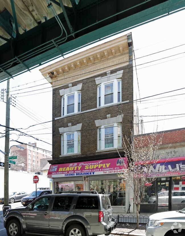
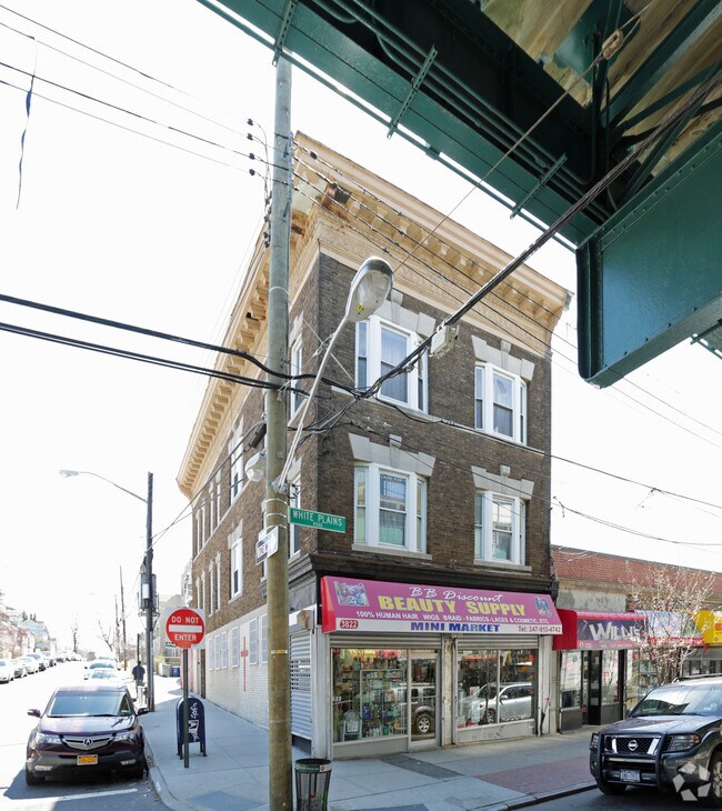
Property Record
3822 White Plains Rd, Bronx, NY 10467
NEARBY LISTINGS FOR SALE OR LEASE
Property Detail
3822 White Plains Rd
04667-0058
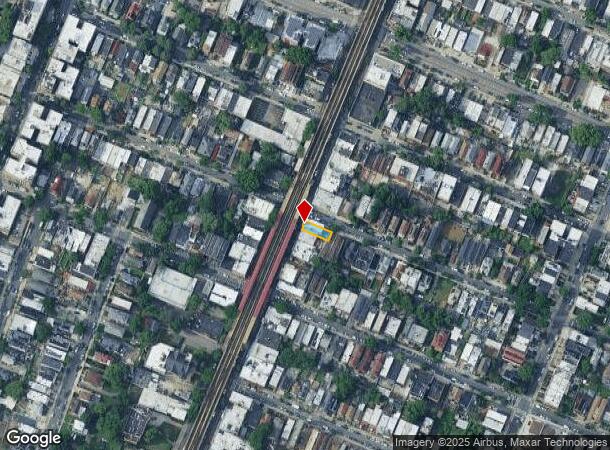
Map Of Village Of Wakefield
Religious
Bronx
X
New York
36119C0338F
58
2024
0.05 AC
2025
Bronx
039600
Westchester/So Connecticut
5,250 SF
New York-Jersey City-White Plains, NY-NJ
DEMOGRAPHICS near 3822 White Plains Rd
1 mile
3 mile
5 mile
2024 Total Population
100,756
722,290
1,652,518
2029 Population
90,740
670,282
1,543,328
Pop Growth 2024-2029
(9.94%)
(7.20%)
(6.61%)
Average Age
38
39
39
2024 Total Households
35,870
262,866
596,215
HH Growth 2024-2029
(10.61%)
(7.77%)
(7.10%)
Median Household Inc
$48,205
$53,440
$49,864
Avg Household Size
2.70
2.60
2.60
2024 Avg HH Vehicles
1.00
1.00
1.00
Median Home Value
$569,637
$463,991
$506,702
Median Year Built
1949
1950
1951
Nearby Places
Map Layers
Map Styles
 Street
 Aerial
Transit
 Traffic
 Biking
Places
Listings with unknown addresses are not visible on the map
- Restaurants
- Banks
- Shops
- Fitness
- Groceries
PUBLIC TRANSPORTATION
TRANSIT/SUBWAY
219 Street (2 - New York MTA Subway (The Subway), 5 - New York MTA Subway (The Subway))
Drive
Walk
Distance
219 Street (2 - New York MTA Subway (The Subway), 5 - New York MTA Subway (The Subway))
2 min
1 min
0.1 mi
225 Street (2 - New York MTA Subway (The Subway), 5 - New York MTA Subway (The Subway))
Drive
Walk
Distance
225 Street (2 - New York MTA Subway (The Subway), 5 - New York MTA Subway (The Subway))
1 min
5 min
0.3 mi
Gun Hill Road (2,5 Line) (2 - New York MTA Subway (The Subway), 5 - New York MTA Subway (The Subway))
Drive
Walk
Distance
Gun Hill Road (2,5 Line) (2 - New York MTA Subway (The Subway), 5 - New York MTA Subway (The Subway))
2 min
11 min
0.5 mi
233 Street (2 - New York MTA Subway (The Subway), 5 - New York MTA Subway (The Subway))
Drive
Walk
Distance
233 Street (2 - New York MTA Subway (The Subway), 5 - New York MTA Subway (The Subway))
2 min
14 min
0.7 mi
Williams Bridge Station (Harlem Line - Metro-North Commuter Railroad Company (Metro-North))
Drive
Walk
Distance
Williams Bridge Station (Harlem Line - Metro-North Commuter Railroad Company (Metro-North))
2 min
15 min
0.7 mi
COMMUTER RAIL
Williams Bridge Station (Harlem Line - Metro-North Commuter Railroad Company (Metro-North))
Drive
Walk
Distance
Williams Bridge Station (Harlem Line - Metro-North Commuter Railroad Company (Metro-North))
2 min
15 min
0.7 mi
Woodlawn Station (Harlem Line - Metro-North Commuter Railroad Company (Metro-North))
Drive
Walk
Distance
Woodlawn Station (Harlem Line - Metro-North Commuter Railroad Company (Metro-North))
4 min
20 min
1.0 mi
AIRPORT
LaGuardia
Drive
Walk
Distance
LaGuardia
24 min
12.6 mi
Westchester County
Drive
Walk
Distance
Westchester County
31 min
19.5 mi
John F Kennedy International
Drive
Walk
Distance
John F Kennedy International
32 min
20.0 mi
Freight Ports
NY - Red Hook Container Terminal
Drive
Walk
Distance
NY - Red Hook Container Terminal
37 min
20.8 mi
Nearby Properties
Address
Land Use
TOTAL SIZE
Lot Size
Zoning
Address
Land Use
TOTAL SIZE
Lot Size
Zoning
115.90 AC
R6
Address
Land Use
TOTAL SIZE
Lot Size
Zoning
115.90 AC
R6
Address
Land Use
TOTAL SIZE
Lot Size
Zoning
115.90 AC
R6
Address
Land Use
TOTAL SIZE
Lot Size
Zoning
115.90 AC
R6
Address
Land Use
TOTAL SIZE
Lot Size
Zoning
115.90 AC
R6
Address
Land Use
TOTAL SIZE
Lot Size
Zoning
115.90 AC
R6
Address
Land Use
TOTAL SIZE
Lot Size
Zoning
115.90 AC
R6
Address
Land Use
TOTAL SIZE
Lot Size
Zoning
115.90 AC
R6
Address
Land Use
TOTAL SIZE
Lot Size
Zoning
115.90 AC
R6
Address
Land Use
TOTAL SIZE
Lot Size
Zoning
115.90 AC
R6
Address
Land Use
TOTAL SIZE
Lot Size
Zoning
115.90 AC
R6
Address
Land Use
TOTAL SIZE
Lot Size
Zoning
115.90 AC
R6
Address
Land Use
TOTAL SIZE
Lot Size
Zoning
115.90 AC
R6
Address
Land Use
TOTAL SIZE
Lot Size
Zoning
115.90 AC
R6
Address
Land Use
TOTAL SIZE
Lot Size
Zoning
115.90 AC
R6
Address
Land Use
TOTAL SIZE
Lot Size
Zoning
115.90 AC
R6
Address
Land Use
TOTAL SIZE
Lot Size
Zoning
115.90 AC
R6
Address
Land Use
TOTAL SIZE
Lot Size
Zoning
115.90 AC
R6
Address
Land Use
TOTAL SIZE
Lot Size
Zoning
115.90 AC
R6
Address
Land Use
TOTAL SIZE
Lot Size
Zoning
115.90 AC
R6
Address
Land Use
TOTAL SIZE
Lot Size
Zoning
115.90 AC
R6
Address
Land Use
TOTAL SIZE
Lot Size
Zoning
115.90 AC
R6
Address
Land Use
TOTAL SIZE
Lot Size
Zoning
115.90 AC
R6
Address
Land Use
TOTAL SIZE
Lot Size
Zoning
115.90 AC
R6
Address
Land Use
TOTAL SIZE
Lot Size
Zoning
115.90 AC
R6
Address
Land Use
TOTAL SIZE
Lot Size
Zoning
1,299,700 SF
29.82 AC
R6
Address
Land Use
TOTAL SIZE
Lot Size
Zoning
550,000 SF
8.75 AC
M1-1
Address
Land Use
TOTAL SIZE
Lot Size
Zoning
13,243,398 SF
115.90 AC
R6
Address
Land Use
TOTAL SIZE
Lot Size
Zoning
1,743,584 SF
77.87 AC
R6
Address
Land Use
TOTAL SIZE
Lot Size
Zoning
44.83 AC
R6
The World's #1 Commercial Real Estate Marketplace
Connect with us
© 2026 CoStar Group
The information above has been obtained from sources believed reliable. While we do not doubt its accuracy we have not verified it and make no guarantee, warranty or representation about it. It is your responsibility to independently confirm its accuracy and completeness. Any projections, opinions, assumptions, or estimates used are for example only and do not represent the current or future performance of the property. The value of this transaction to you depends on tax and other factors which should be evaluated by your tax, financial, and legal advisors. You and your advisors should conduct a careful, independent investigation of the property to determine to your satisfaction the suitability of the property for your needs.