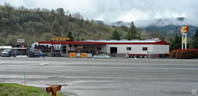
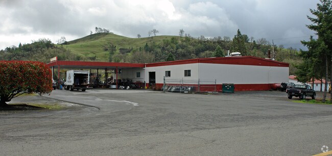
Property Record
3825 Ne Diamond Lake Blvd, Roseburg, OR 97470

Property Detail
3825 Ne Diamond Lake Blvd
R42316
BROOKSIDE 3RD ADD, BLOCK PT 6 S OF HWY, ACRES 4.36
Industrialgeneral
Douglas
M2
Oregon
B and X Area of moderate flood hazard, usually the area between the limits of the 100-year and 500-year floods.
4.36 AC
2025
Oregon West Area
2025
Other Market Areas
120001
Roseburg, OR
12,000 SF
NEARBY LISTINGS FOR SALE OR LEASE
DEMOGRAPHICS near 3825 Ne Diamond Lake Blvd
1 mile
3 mile
5 mile
2025 Total Population
1,127
14,217
33,442
2030 Population
1,189
14,659
34,077
Pop Growth 2025-2030
+ 5.50%
+ 3.11%
+ 1.90%
Average Age
39
42
43
2025 Total Households
450
6,071
14,103
HH Growth 2025-2030
+ 5.56%
+ 3.13%
+ 1.92%
Median Household Inc
$53,472
$53,266
$56,016
Avg Household Size
2.50
2.20
2.20
2025 Avg HH Vehicles
2.00
2.00
2.00
Median Home Value
$289,633
$282,787
$313,003
Median Year Built
1985
1962
1975
Nearby Places
Map Layers
Map Styles
 Street
 Aerial
Layers
 Traffic
 Biking
Places
Listings with unknown addresses are not visible on the map
- Restaurants
- Banks
- Shops
- Fitness
- Groceries
Nearby Properties
Address
Land Use
TOTAL SIZE
Lot Size
Zoning
Address
Land Use
TOTAL SIZE
Lot Size
Zoning
1,000 SF
18.99 AC
PR
Address
Land Use
TOTAL SIZE
Lot Size
Zoning
239,143 SF
6.29 AC
PR
Address
Land Use
TOTAL SIZE
Lot Size
Zoning
145,644 SF
9.08 AC
MU
Address
Land Use
TOTAL SIZE
Lot Size
Zoning
86,285 SF
4.91 AC
C3
Address
Land Use
TOTAL SIZE
Lot Size
Zoning
90,785 SF
2.76 AC
PR
Address
Land Use
TOTAL SIZE
Lot Size
Zoning
1,713 SF
7 AC
MU
Address
Land Use
TOTAL SIZE
Lot Size
Zoning
89,208 SF
5.01 AC
MU
Address
Land Use
TOTAL SIZE
Lot Size
Zoning
2.55 AC
M2
Address
Land Use
TOTAL SIZE
Lot Size
Zoning
15.99 AC
M3
Address
Land Use
TOTAL SIZE
Lot Size
Zoning
129,644 SF
4.85 AC
MU
Address
Land Use
TOTAL SIZE
Lot Size
Zoning
41,353 SF
4.18 AC
C3
Address
Land Use
TOTAL SIZE
Lot Size
Zoning
1,000 SF
26.34 AC
PR
Address
Land Use
TOTAL SIZE
Lot Size
Zoning
55,836 SF
3.97 AC
C3
Address
Land Use
TOTAL SIZE
Lot Size
Zoning
100 SF
3.10 AC
C3
Address
Land Use
TOTAL SIZE
Lot Size
Zoning
44,750 SF
2.47 AC
MR29
Address
Land Use
TOTAL SIZE
Lot Size
Zoning
40,543 SF
4.43 AC
C3
Address
Land Use
TOTAL SIZE
Lot Size
Zoning
20,100 SF
0.30 AC
PR
Address
Land Use
TOTAL SIZE
Lot Size
Zoning
40,000 SF
2.66 AC
C3
Address
Land Use
TOTAL SIZE
Lot Size
Zoning
75,770 SF
6.79 AC
PR
Address
Land Use
TOTAL SIZE
Lot Size
Zoning
66,723 SF
5.70 AC
C3
Address
Land Use
TOTAL SIZE
Lot Size
Zoning
36,425 SF
3.11 AC
C3
Address
Land Use
TOTAL SIZE
Lot Size
Zoning
40,240 SF
1.05 AC
C3
Address
Land Use
TOTAL SIZE
Lot Size
Zoning
9,200 SF
1.45 AC
MU
Address
Land Use
TOTAL SIZE
Lot Size
Zoning
62,790 SF
2.49 AC
MR18
Address
Land Use
TOTAL SIZE
Lot Size
Zoning
30,000 SF
11.92 AC
PR
Address
Land Use
TOTAL SIZE
Lot Size
Zoning
25,960 SF
1.48 AC
C3
Address
Land Use
TOTAL SIZE
Lot Size
Zoning
37,118 SF
1.12 AC
C3
Address
Land Use
TOTAL SIZE
Lot Size
Zoning
11.78 AC
M3
Address
Land Use
TOTAL SIZE
Lot Size
Zoning
51,560 SF
4.77 AC
PR
Address
Land Use
TOTAL SIZE
Lot Size
Zoning
25,035 SF
4.95 AC
C3
The World's #1 Commercial Real Estate Marketplace
Connect with us
© 2026 CoStar Group
The information above has been obtained from sources believed reliable. While we do not doubt its accuracy we have not verified it and make no guarantee, warranty or representation about it. It is your responsibility to independently confirm its accuracy and completeness. Any projections, opinions, assumptions, or estimates used are for example only and do not represent the current or future performance of the property. The value of this transaction to you depends on tax and other factors which should be evaluated by your tax, financial, and legal advisors. You and your advisors should conduct a careful, independent investigation of the property to determine to your satisfaction the suitability of the property for your needs.