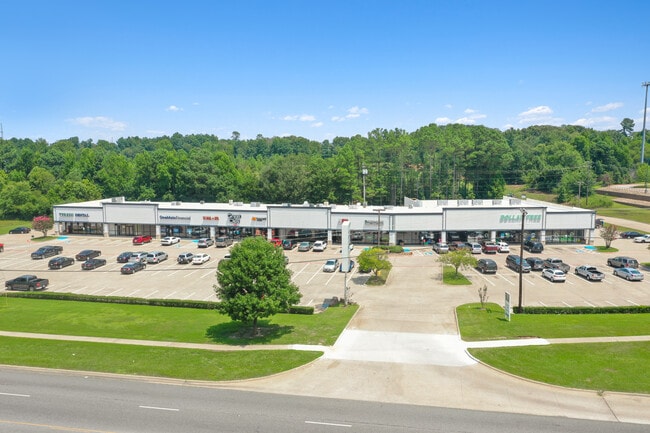
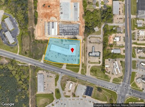
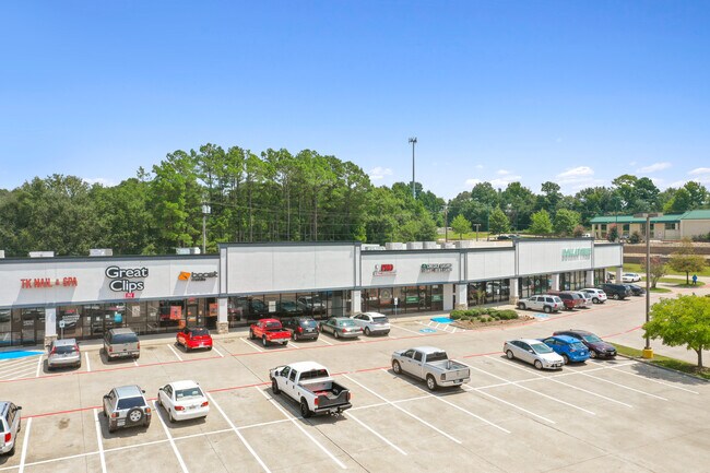
Property Record
3825 State Highway 64 W, Tyler, TX 75704
NEARBY LISTINGS FOR SALE OR LEASE
Property Detail
3825 State Highway 64 W
Tyler, TX
Tyler Corners Addn
1-50000-1245-00-013040
TYLER CORNERS ADDNBLOCK 1245 LOT 13D
Storebuilding
Smith
X
Texas
48423C0355D
13d
2024
3.48 AC
2025
Tyler & Longview
001608
Other Market Areas
32,175 SF
DEMOGRAPHICS near 3825 State Highway 64 W
1 Mile
3 Mile
5 Mile
2024 Total Population
2,111
38,329
78,971
2029 Population
2,280
41,802
85,843
Pop Growth 2024-2029
+ 8.01%
+ 9.06%
+ 8.70%
Average Age
34
36
37
2024 Total Households
677
13,640
29,061
HH Growth 2024-2029
+ 7.39%
+ 8.55%
+ 8.13%
Median Household Inc
$41,458
$47,060
$50,887
Avg Household Size
2.90
2.60
2.50
2024 Avg HH Vehicles
2.00
2.00
2.00
Median Home Value
$91,062
$110,448
$147,975
Median Year Built
1970
1965
1970
Nearby Places
Map Layers
Map Styles
 Street
 Aerial
- Restaurants
- Banks
- Shops
- Fitness
- Groceries
PUBLIC TRANSPORTATION
AIRPORT
Tyler Pounds Regional
DRIVE
WALK
Distance
Tyler Pounds Regional
11 min
5.1 mi
Freight Ports
Port of Shreveport
DRIVE
WALK
Distance
Port of Shreveport
125 min
109.1 mi
SALE & LEASE HISTORY
LISTING DATE
SALE/LEASE

Jan 02, 2019
For Sale
Nearby Properties
Address
Land Use
TOTAL SIZE
Lot Size
Zoning
Address
Land Use
TOTAL SIZE
Lot Size
Zoning
11,332 SF
22.07 AC
PMF
Address
Land Use
TOTAL SIZE
Lot Size
Zoning
24.83 AC
Address
Land Use
TOTAL SIZE
Lot Size
Zoning
39.16 AC
C2
Address
Land Use
TOTAL SIZE
Lot Size
Zoning
31.74 AC
Address
Land Use
TOTAL SIZE
Lot Size
Zoning
1.78 AC
DBAC
Address
Land Use
TOTAL SIZE
Lot Size
Zoning
84,560 SF
15.70 AC
M1
Address
Land Use
TOTAL SIZE
Lot Size
Zoning
Address
Land Use
TOTAL SIZE
Lot Size
Zoning
187.64 AC
R1A
Address
Land Use
TOTAL SIZE
Lot Size
Zoning
237,916 SF
11.17 AC
PMF
Address
Land Use
TOTAL SIZE
Lot Size
Zoning
126.94 AC
Address
Land Use
TOTAL SIZE
Lot Size
Zoning
3,806 SF
18.86 AC
RMF
Address
Land Use
TOTAL SIZE
Lot Size
Zoning
63 AC
R1A
Address
Land Use
TOTAL SIZE
Lot Size
Zoning
207,919 SF
1.90 AC
DBAC
Address
Land Use
TOTAL SIZE
Lot Size
Zoning
22.85 AC
Address
Land Use
TOTAL SIZE
Lot Size
Zoning
2,802 SF
14 AC
RMF
Address
Land Use
TOTAL SIZE
Lot Size
Zoning
25.54 AC
INT
Address
Land Use
TOTAL SIZE
Lot Size
Zoning
181,260 SF
2.06 AC
DBAC
Address
Land Use
TOTAL SIZE
Lot Size
Zoning
14.16 AC
Address
Land Use
TOTAL SIZE
Lot Size
Zoning
129,070 SF
3.75 AC
Address
Land Use
TOTAL SIZE
Lot Size
Zoning
22,500 SF
6.98 AC
Address
Land Use
TOTAL SIZE
Lot Size
Zoning
5 AC
R1B
Address
Land Use
TOTAL SIZE
Lot Size
Zoning
45,114 SF
30.60 AC
Address
Land Use
TOTAL SIZE
Lot Size
Zoning
80,070 SF
9.04 AC
Address
Land Use
TOTAL SIZE
Lot Size
Zoning
43,300 SF
2.17 AC
DBAC
Address
Land Use
TOTAL SIZE
Lot Size
Zoning
205,196 SF
25.19 AC
C2
Address
Land Use
TOTAL SIZE
Lot Size
Zoning
85,804 SF
8.69 AC
M1
Address
Land Use
TOTAL SIZE
Lot Size
Zoning
14.02 AC
R2
Address
Land Use
TOTAL SIZE
Lot Size
Zoning
Address
Land Use
TOTAL SIZE
Lot Size
Zoning
2.38 AC
DBAC
Address
Land Use
TOTAL SIZE
Lot Size
Zoning
3,222 SF
7.43 AC
RMF
The World's #1 Commercial Real Estate Marketplace
Connect with us
© 2026 CoStar Group
The information above has been obtained from sources believed reliable. While we do not doubt its accuracy we have not verified it and make no guarantee, warranty or representation about it. It is your responsibility to independently confirm its accuracy and completeness. Any projections, opinions, assumptions, or estimates used are for example only and do not represent the current or future performance of the property. The value of this transaction to you depends on tax and other factors which should be evaluated by your tax, financial, and legal advisors. You and your advisors should conduct a careful, independent investigation of the property to determine to your satisfaction the suitability of the property for your needs.