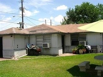
Property Record
3826 Seabrook St, Houston, TX 77021


NEARBY LISTINGS FOR SALE OR LEASE
Property Detail
3826 Seabrook St
Houston-The Woodlands-Sugar Land, TX
South End Sunnyside U/R
0741520120006
LTS 6 & 7 BLK 12 SOUTH END SUNNYSIDE U/R
Apartment
Harris
X
Texas
48201C0890M
6,7
2024
0.23 AC
2025
OST-South Union
313801
Houston
4,656 SF
DEMOGRAPHICS near 3826 Seabrook St
1 Mile
3 Mile
5 Mile
2024 Total Population
16,838
141,877
400,581
2029 Population
17,498
146,707
414,157
Pop Growth 2024-2029
+ 3.92%
+ 3.40%
+ 3.39%
Average Age
36
36
37
2024 Total Households
6,426
55,268
168,201
HH Growth 2024-2029
+ 4.03%
+ 3.66%
+ 3.56%
Median Household Inc
$29,788
$44,929
$58,614
Avg Household Size
2.50
2.20
2.20
2024 Avg HH Vehicles
1.00
1.00
1.00
Median Home Value
$146,753
$165,946
$274,143
Median Year Built
1969
1979
1984
Nearby Places
Map Layers
Map Styles
 Street
 Aerial
- Restaurants
- Banks
- Shops
- Fitness
- Groceries
PUBLIC TRANSPORTATION
COMMUTER RAIL
Houston (Sunset Limited - Amtrak)
DRIVE
WALK
Distance
Houston (Sunset Limited - Amtrak)
13 min
7.3 mi
AIRPORT
William P Hobby
DRIVE
WALK
Distance
William P Hobby
20 min
9.8 mi
George Bush Intcntl/Houston
DRIVE
WALK
Distance
George Bush Intcntl/Houston
33 min
24.6 mi
Freight Ports
Port of Houston
DRIVE
WALK
Distance
Port of Houston
17 min
10.0 mi
SALE & LEASE HISTORY
LISTING DATE
SALE/LEASE

Apr 30, 2022
For Sale
Nearby Properties
Address
Land Use
TOTAL SIZE
Lot Size
Zoning
Address
Land Use
TOTAL SIZE
Lot Size
Zoning
519,409 SF
1.52 AC
Address
Land Use
TOTAL SIZE
Lot Size
Zoning
1,252,274 SF
2.02 AC
Address
Land Use
TOTAL SIZE
Lot Size
Zoning
704,249 SF
2.34 AC
Address
Land Use
TOTAL SIZE
Lot Size
Zoning
1,359,194 SF
Address
Land Use
TOTAL SIZE
Lot Size
Zoning
402,467 SF
28.30 AC
Address
Land Use
TOTAL SIZE
Lot Size
Zoning
577,327 SF
28.80 AC
Address
Land Use
TOTAL SIZE
Lot Size
Zoning
396,888 SF
2.02 AC
Address
Land Use
TOTAL SIZE
Lot Size
Zoning
486,076 SF
3.79 AC
Address
Land Use
TOTAL SIZE
Lot Size
Zoning
453,987 SF
4.33 AC
Address
Land Use
TOTAL SIZE
Lot Size
Zoning
527,457 SF
6.21 AC
Address
Land Use
TOTAL SIZE
Lot Size
Zoning
706,892 SF
5.86 AC
Address
Land Use
TOTAL SIZE
Lot Size
Zoning
562,131 SF
4.11 AC
Address
Land Use
TOTAL SIZE
Lot Size
Zoning
356,610 SF
2.26 AC
Address
Land Use
TOTAL SIZE
Lot Size
Zoning
557,397 SF
5.58 AC
Address
Land Use
TOTAL SIZE
Lot Size
Zoning
353,738 SF
2.04 AC
Address
Land Use
TOTAL SIZE
Lot Size
Zoning
287,348 SF
1.15 AC
Address
Land Use
TOTAL SIZE
Lot Size
Zoning
651,551 SF
52.18 AC
Address
Land Use
TOTAL SIZE
Lot Size
Zoning
372,028 SF
26.56 AC
Address
Land Use
TOTAL SIZE
Lot Size
Zoning
499,978 SF
5.57 AC
Address
Land Use
TOTAL SIZE
Lot Size
Zoning
643,698 SF
6.57 AC
Address
Land Use
TOTAL SIZE
Lot Size
Zoning
354,377 SF
8.10 AC
Address
Land Use
TOTAL SIZE
Lot Size
Zoning
410,109 SF
0.69 AC
Address
Land Use
TOTAL SIZE
Lot Size
Zoning
473,040 SF
0.72 AC
Address
Land Use
TOTAL SIZE
Lot Size
Zoning
365,485 SF
13.94 AC
Address
Land Use
TOTAL SIZE
Lot Size
Zoning
397,924 SF
3.64 AC
Address
Land Use
TOTAL SIZE
Lot Size
Zoning
380,761 SF
0.92 AC
Address
Land Use
TOTAL SIZE
Lot Size
Zoning
257,963 SF
6.39 AC
Address
Land Use
TOTAL SIZE
Lot Size
Zoning
518,025 SF
18.09 AC
Address
Land Use
TOTAL SIZE
Lot Size
Zoning
53,600 SF
21.34 AC
Address
Land Use
TOTAL SIZE
Lot Size
Zoning
474,970 SF
6.95 AC
The World's #1 Commercial Real Estate Marketplace
Connect with us
© 2026 CoStar Group
The information above has been obtained from sources believed reliable. While we do not doubt its accuracy we have not verified it and make no guarantee, warranty or representation about it. It is your responsibility to independently confirm its accuracy and completeness. Any projections, opinions, assumptions, or estimates used are for example only and do not represent the current or future performance of the property. The value of this transaction to you depends on tax and other factors which should be evaluated by your tax, financial, and legal advisors. You and your advisors should conduct a careful, independent investigation of the property to determine to your satisfaction the suitability of the property for your needs.