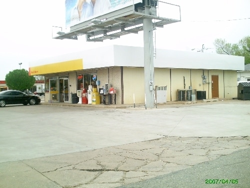
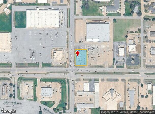
Property Record
3826 W Owen K Garriott Rd, Enid, OK 73703
NEARBY LISTINGS FOR SALE OR LEASE
-
-
-
No Photo
-
-
-
-
-
View all Enid listings for sale on LoopNet.com
Property Detail
3826 W Owen K Garriott Rd
Enid, OK
King's Garden Addn
2950-00-001-005-0-004-00
LOT 5 BLOCK 1 (EX N 365' & S 32' FOR HWY) SD-E57 KING'S GARDEN ADDN SW/4 11-22-7 ARBY'S LEASE- SIGN, PAVING, BLDG BONNIE HOLD
Restaurantdrivein
Garfield
X
Oklahoma
40047C0193F
5
2024
0.68 AC
2025
Oklahoma West Area
001402
Other Market Areas
3,377 SF
DEMOGRAPHICS near 3826 W Owen K Garriott Rd
1 Mile
3 Mile
5 Mile
2024 Total Population
6,985
31,526
51,969
2029 Population
6,816
30,908
51,227
Pop Growth 2024-2029
(2.42%)
(1.96%)
(1.43%)
Average Age
40
39
38
2024 Total Households
2,955
12,964
20,123
HH Growth 2024-2029
(2.40%)
(1.97%)
(1.48%)
Median Household Inc
$64,823
$62,080
$58,146
Avg Household Size
2.30
2.40
2.50
2024 Avg HH Vehicles
2.00
2.00
2.00
Median Home Value
$153,747
$164,479
$144,070
Median Year Built
1977
1973
1970
Nearby Places
Map Layers
Map Styles
 Street
 Aerial
- Restaurants
- Banks
- Shops
- Fitness
- Groceries
Nearby Properties
Address
Land Use
TOTAL SIZE
Lot Size
Zoning
Address
Land Use
TOTAL SIZE
Lot Size
Zoning
16,445 SF
2.49 AC
Address
Land Use
TOTAL SIZE
Lot Size
Zoning
79,801 SF
3.26 AC
Address
Land Use
TOTAL SIZE
Lot Size
Zoning
84,154 SF
21.81 AC
CR
Address
Land Use
TOTAL SIZE
Lot Size
Zoning
207,942 SF
2.07 AC
Address
Land Use
TOTAL SIZE
Lot Size
Zoning
132,603 SF
17.42 AC
Address
Land Use
TOTAL SIZE
Lot Size
Zoning
28,160 SF
2.68 AC
Address
Land Use
TOTAL SIZE
Lot Size
Zoning
169,463 SF
30 AC
Address
Land Use
TOTAL SIZE
Lot Size
Zoning
69,406 SF
2.10 AC
Address
Land Use
TOTAL SIZE
Lot Size
Zoning
40,206 SF
3.29 AC
Address
Land Use
TOTAL SIZE
Lot Size
Zoning
56,466 SF
10.04 AC
CR
Address
Land Use
TOTAL SIZE
Lot Size
Zoning
67,830 SF
2.94 AC
Address
Land Use
TOTAL SIZE
Lot Size
Zoning
53,763 SF
32.48 AC
Address
Land Use
TOTAL SIZE
Lot Size
Zoning
70,020 SF
1.03 AC
Address
Land Use
TOTAL SIZE
Lot Size
Zoning
33,501 SF
2.59 AC
Address
Land Use
TOTAL SIZE
Lot Size
Zoning
46,653 SF
2.20 AC
Address
Land Use
TOTAL SIZE
Lot Size
Zoning
51,174 SF
2.20 AC
Address
Land Use
TOTAL SIZE
Lot Size
Zoning
64,600 SF
8.36 AC
Address
Land Use
TOTAL SIZE
Lot Size
Zoning
71,732 SF
3.33 AC
Address
Land Use
TOTAL SIZE
Lot Size
Zoning
33,831 SF
1.33 AC
Address
Land Use
TOTAL SIZE
Lot Size
Zoning
48,487 SF
1.03 AC
Address
Land Use
TOTAL SIZE
Lot Size
Zoning
44,764 SF
4.35 AC
Address
Land Use
TOTAL SIZE
Lot Size
Zoning
30,997 SF
5.97 AC
Address
Land Use
TOTAL SIZE
Lot Size
Zoning
21,770 SF
3.98 AC
Address
Land Use
TOTAL SIZE
Lot Size
Zoning
14,076 SF
2.94 AC
Address
Land Use
TOTAL SIZE
Lot Size
Zoning
14,974 SF
1.89 AC
Address
Land Use
TOTAL SIZE
Lot Size
Zoning
14,904 SF
10 AC
Address
Land Use
TOTAL SIZE
Lot Size
Zoning
46,421 SF
4.50 AC
Address
Land Use
TOTAL SIZE
Lot Size
Zoning
25,654 SF
2.26 AC
Address
Land Use
TOTAL SIZE
Lot Size
Zoning
14,327 SF
4.25 AC
Address
Land Use
TOTAL SIZE
Lot Size
Zoning
40,752 SF
1.35 AC
The World's #1 Commercial Real Estate Marketplace
Connect with us
© 2025 CoStar Group
The information above has been obtained from sources believed reliable. While we do not doubt its accuracy we have not verified it and make no guarantee, warranty or representation about it. It is your responsibility to independently confirm its accuracy and completeness. Any projections, opinions, assumptions, or estimates used are for example only and do not represent the current or future performance of the property. The value of this transaction to you depends on tax and other factors which should be evaluated by your tax, financial, and legal advisors. You and your advisors should conduct a careful, independent investigation of the property to determine to your satisfaction the suitability of the property for your needs.