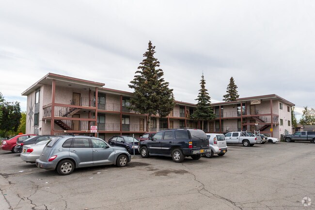
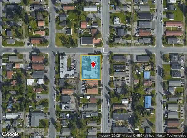
Property Record
3830 Parsons Ave, Anchorage, AK 99508

NEARBY LISTINGS FOR SALE OR LEASE
-
-
View all Anchorage listings for sale on LoopNet.com
Property Detail
3830 Parsons Ave
Anchorage, AK
Mountain View
00404112000
MOUNTAIN VIEW BLK 20 LT 4 E2
Apartment
Anchorage
X
Alaska
0200050760D
4
2024
0.43 AC
2025
Mountain View
000601
Anchorage
15,780 SF
DEMOGRAPHICS near 3830 Parsons Ave
1 Mile
3 Mile
5 Mile
2024 Total Population
12,606
75,185
142,348
2029 Population
12,509
74,557
141,024
Pop Growth 2024-2029
(0.77%)
(0.84%)
(0.93%)
Average Age
33
35
36
2024 Total Households
4,165
27,784
54,495
HH Growth 2024-2029
(0.94%)
(0.91%)
(0.98%)
Median Household Inc
$47,526
$66,078
$71,568
Avg Household Size
2.70
2.40
2.40
2024 Avg HH Vehicles
2.00
2.00
2.00
Median Home Value
$235,952
$278,809
$290,405
Median Year Built
1976
1977
1978
Nearby Places
Map Layers
Map Styles
 Street
 Aerial
- Restaurants
- Banks
- Shops
- Fitness
- Groceries
PUBLIC TRANSPORTATION
AIRPORT
Merrill Field
DRIVE
WALK
Distance
Merrill Field
5 min
2.2 mi
Ted Stevens Anchorage International
DRIVE
WALK
Distance
Ted Stevens Anchorage International
18 min
9.9 mi
Freight Ports
Port of Anchorage
DRIVE
WALK
Distance
Port of Anchorage
11 min
4.7 mi
Nearby Properties
Address
Land Use
TOTAL SIZE
Lot Size
Zoning
Address
Land Use
TOTAL SIZE
Lot Size
Zoning
658,690 SF
70.86 AC
PLI
Address
Land Use
TOTAL SIZE
Lot Size
Zoning
22,362 SF
71.05 AC
PLI
Address
Land Use
TOTAL SIZE
Lot Size
Zoning
14,009 SF
24.86 AC
PLI
Address
Land Use
TOTAL SIZE
Lot Size
Zoning
160,830 SF
41.64 AC
PLI
Address
Land Use
TOTAL SIZE
Lot Size
Zoning
127,232 SF
4.55 AC
B2B
Address
Land Use
TOTAL SIZE
Lot Size
Zoning
171,692 SF
23.09 AC
I1
Address
Land Use
TOTAL SIZE
Lot Size
Zoning
33,906 SF
40 AC
PLI
Address
Land Use
TOTAL SIZE
Lot Size
Zoning
87,865 SF
0.48 AC
B2B
Address
Land Use
TOTAL SIZE
Lot Size
Zoning
181,000 SF
7.54 AC
PLI
Address
Land Use
TOTAL SIZE
Lot Size
Zoning
179,543 SF
26.03 AC
PLI
Address
Land Use
TOTAL SIZE
Lot Size
Zoning
171,604 SF
30.51 AC
PLI
Address
Land Use
TOTAL SIZE
Lot Size
Zoning
133,758 SF
2.36 AC
ROSL
Address
Land Use
TOTAL SIZE
Lot Size
Zoning
33,360 SF
0.96 AC
B2B
Address
Land Use
TOTAL SIZE
Lot Size
Zoning
294,060 SF
69.74 AC
PLI
Address
Land Use
TOTAL SIZE
Lot Size
Zoning
320,366 SF
36.42 AC
PLI
Address
Land Use
TOTAL SIZE
Lot Size
Zoning
7,711 SF
1.93 AC
B2A
Address
Land Use
TOTAL SIZE
Lot Size
Zoning
170,000 SF
2.40 AC
B2A
Address
Land Use
TOTAL SIZE
Lot Size
Zoning
173,845 SF
19.98 AC
R2A
Address
Land Use
TOTAL SIZE
Lot Size
Zoning
110,608 SF
9.44 AC
I2
Address
Land Use
TOTAL SIZE
Lot Size
Zoning
68,191 SF
5.39 AC
B3
Address
Land Use
TOTAL SIZE
Lot Size
Zoning
8,189 SF
26.11 AC
R3
Address
Land Use
TOTAL SIZE
Lot Size
Zoning
81,884 SF
0.30 AC
B2A
Address
Land Use
TOTAL SIZE
Lot Size
Zoning
119,584 SF
2.07 AC
B2A
Address
Land Use
TOTAL SIZE
Lot Size
Zoning
34,008 SF
0.64 AC
B2A
Address
Land Use
TOTAL SIZE
Lot Size
Zoning
48.70 AC
PLI
Address
Land Use
TOTAL SIZE
Lot Size
Zoning
608,756 SF
0.15 AC
B2C
Address
Land Use
TOTAL SIZE
Lot Size
Zoning
190,766 SF
16.45 AC
I1
Address
Land Use
TOTAL SIZE
Lot Size
Zoning
9,036 SF
6.81 AC
B3
Address
Land Use
TOTAL SIZE
Lot Size
Zoning
62,020 SF
12.42 AC
I1SL
Address
Land Use
TOTAL SIZE
Lot Size
Zoning
159,834 SF
0.98 AC
ROSL
The World's #1 Commercial Real Estate Marketplace
Connect with us
© 2025 CoStar Group
The information above has been obtained from sources believed reliable. While we do not doubt its accuracy we have not verified it and make no guarantee, warranty or representation about it. It is your responsibility to independently confirm its accuracy and completeness. Any projections, opinions, assumptions, or estimates used are for example only and do not represent the current or future performance of the property. The value of this transaction to you depends on tax and other factors which should be evaluated by your tax, financial, and legal advisors. You and your advisors should conduct a careful, independent investigation of the property to determine to your satisfaction the suitability of the property for your needs.