Property Record
3830 State Route 31, Liverpool, NY 13090
NEARBY LISTINGS FOR SALE OR LEASE
Property Detail
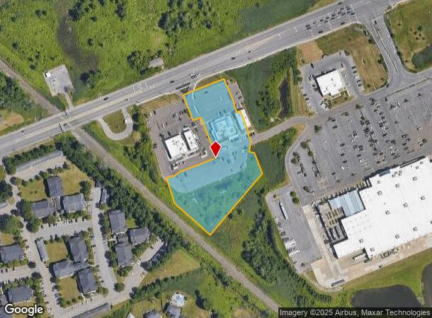
3830 State Route 31
312489-053-000-0001-019-006-0000
Onondaga
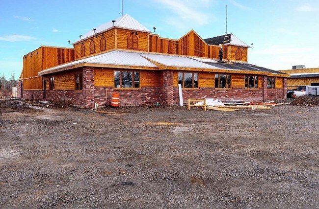
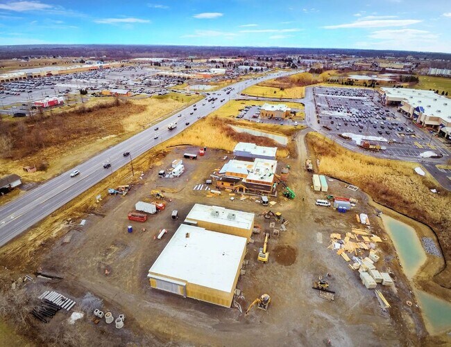
Restaurantbuilding
New York
X
19.006
36067C0086F
2.72 AC
2025
NE Outer Onondaga County
2024
Syracuse
011202
Syracuse, NY
7,315 SF
DEMOGRAPHICS near 3830 State Route 31
1 Mile
3 Mile
5 Mile
2024 Total Population
6,384
29,844
69,584
2029 Population
6,260
29,076
67,829
Pop Growth 2024-2029
(1.94%)
(2.57%)
(2.52%)
Average Age
41
42
42
2024 Total Households
2,795
12,180
29,086
HH Growth 2024-2029
(2.22%)
(2.77%)
(2.72%)
Median Household Inc
$74,759
$83,398
$78,300
Avg Household Size
2.20
2.40
2.30
2024 Avg HH Vehicles
2.00
2.00
2.00
Median Home Value
$185,912
$193,633
$182,140
Median Year Built
1987
1984
1978
Nearby Places
- Restaurants
- Banks
- Shops
- Fitness
- Groceries
PUBLIC TRANSPORTATION
AIRPORT
Syracuse Hancock International
DRIVE
WALK
Distance
Syracuse Hancock International
17 min
11.7 mi
Freight Ports
Albany, NY Port
DRIVE
WALK
Distance
Albany, NY Port
180 min
151.8 mi
SALE & LEASE HISTORY
LISTING DATE
SALE/LEASE

Sep 11, 2019
For Sale
Nearby Properties
Address
Land Use
TOTAL SIZE
Lot Size
Zoning
Address
Land Use
TOTAL SIZE
Lot Size
Zoning
38,960 SF
21.26 AC
PUD
Address
Land Use
TOTAL SIZE
Lot Size
Zoning
99,442 SF
11.75 AC
PUD
Address
Land Use
TOTAL SIZE
Lot Size
Zoning
28,800 SF
6.86 AC
R40
Address
Land Use
TOTAL SIZE
Lot Size
Zoning
5,400 SF
6.47 AC
PUD
Address
Land Use
TOTAL SIZE
Lot Size
Zoning
61,701 SF
15.87 AC
R40
Address
Land Use
TOTAL SIZE
Lot Size
Zoning
6,983 SF
9.21 AC
PUD
Address
Land Use
TOTAL SIZE
Lot Size
Zoning
2,520 SF
16.28 AC
FED
Address
Land Use
TOTAL SIZE
Lot Size
Zoning
28,800 SF
4.72 AC
PUD
Address
Land Use
TOTAL SIZE
Lot Size
Zoning
34,535 SF
5 AC
PUD
Address
Land Use
TOTAL SIZE
Lot Size
Zoning
28,800 SF
3.19 AC
PUD
Address
Land Use
TOTAL SIZE
Lot Size
Zoning
10,330 SF
241.94 AC
PUD
Address
Land Use
TOTAL SIZE
Lot Size
Zoning
9,198 SF
6.59 AC
PUD
Address
Land Use
TOTAL SIZE
Lot Size
Zoning
309,390 SF
68.49 AC
05 - COMME
Address
Land Use
TOTAL SIZE
Lot Size
Zoning
17,725 SF
4.91 AC
PUD
Address
Land Use
TOTAL SIZE
Lot Size
Zoning
6,528 SF
27.74 AC
PUD
Address
Land Use
TOTAL SIZE
Lot Size
Zoning
2,920 SF
13.70 AC
PUD
Address
Land Use
TOTAL SIZE
Lot Size
Zoning
6,724 SF
10.05 AC
PUD
Address
Land Use
TOTAL SIZE
Lot Size
Zoning
17,628 SF
2.76 AC
PUD
Address
Land Use
TOTAL SIZE
Lot Size
Zoning
24,830 SF
3.77 AC
PUD
Address
Land Use
TOTAL SIZE
Lot Size
Zoning
5,371 SF
154.56 AC
PUD
Address
Land Use
TOTAL SIZE
Lot Size
Zoning
43,420 SF
5.02 AC
PUD
Address
Land Use
TOTAL SIZE
Lot Size
Zoning
50,428 SF
6.41 AC
PUD
Address
Land Use
TOTAL SIZE
Lot Size
Zoning
65,320 SF
12.97 AC
C-1
Address
Land Use
TOTAL SIZE
Lot Size
Zoning
29,682 SF
3.03 AC
PUD
Address
Land Use
TOTAL SIZE
Lot Size
Zoning
40,634 SF
3.80 AC
PUD
Address
Land Use
TOTAL SIZE
Lot Size
Zoning
29,700 SF
2.50 AC
PUD
Address
Land Use
TOTAL SIZE
Lot Size
Zoning
43,592 SF
8.14 AC
PUD
Address
Land Use
TOTAL SIZE
Lot Size
Zoning
79.90 AC
PUD
Address
Land Use
TOTAL SIZE
Lot Size
Zoning
12,636 SF
1.58 AC
PUD
Address
Land Use
TOTAL SIZE
Lot Size
Zoning
39,198 SF
4.85 AC
PUD
The World's #1 Commercial Real Estate Marketplace
Connect with us
© 2025 CoStar Group
The information above has been obtained from sources believed reliable. While we do not doubt its accuracy we have not verified it and make no guarantee, warranty or representation about it. It is your responsibility to independently confirm its accuracy and completeness. Any projections, opinions, assumptions, or estimates used are for example only and do not represent the current or future performance of the property. The value of this transaction to you depends on tax and other factors which should be evaluated by your tax, financial, and legal advisors. You and your advisors should conduct a careful, independent investigation of the property to determine to your satisfaction the suitability of the property for your needs.