Property Record
2715 Fairwinds Ln, Hope Mills, NC 28348
NEARBY LISTINGS FOR SALE OR LEASE
-
-
View all Hope Mills listings for sale on LoopNet.com
Property Detail
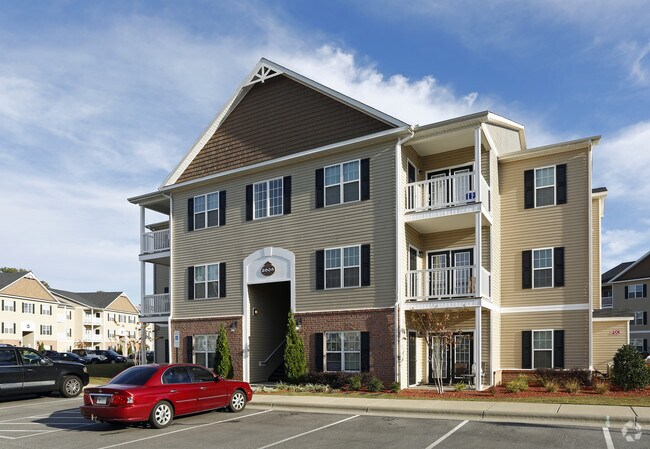
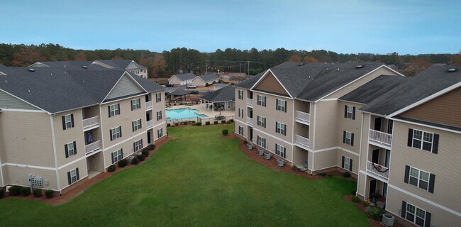
2715 Fairwinds Ln
Fayetteville, NC
Kings Quarters
9494-65-2486
CUMB CO BD OF ED JACK BRITT HS LO:MAJ PT 3 SE:01 PL:0100-0165
Apartment
Cumberland
X
North Carolina
3710949400J
3
2025
3.82 AC
2025
Jack Britt/Porter Place
003106
Fayetteville
4,956 SF
DEMOGRAPHICS near 2715 Fairwinds Ln
1 Mile
3 Mile
5 Mile
2024 Total Population
4,769
35,851
86,743
2029 Population
4,766
35,763
86,830
Pop Growth 2024-2029
(0.06%)
(0.25%)
+ 0.10%
Average Age
35
35
36
2024 Total Households
1,558
12,518
32,223
HH Growth 2024-2029
(0.06%)
(0.26%)
+ 0.06%
Median Household Inc
$87,270
$71,701
$59,798
Avg Household Size
3.00
2.80
2.60
2024 Avg HH Vehicles
2.00
2.00
2.00
Median Home Value
$258,412
$196,313
$163,926
Median Year Built
1997
1994
1990
Nearby Places
Map Layers
Map Styles
 Street
 Aerial
- Restaurants
- Banks
- Shops
- Fitness
- Groceries
PUBLIC TRANSPORTATION
AIRPORT
Fayetteville Regional/Grannis Field
DRIVE
WALK
Distance
Fayetteville Regional/Grannis Field
16 min
9.9 mi
Freight Ports
Port of Wilmington
DRIVE
WALK
Distance
Port of Wilmington
132 min
94.5 mi
SALE & LEASE HISTORY
LISTING DATE
SALE/LEASE

Sep 24, 2016
For Sale
Jan 23, 2020
For Sale
Nearby Properties
Address
Land Use
TOTAL SIZE
Lot Size
Zoning
Address
Land Use
TOTAL SIZE
Lot Size
Zoning
161,719 SF
107.14 AC
RR
Address
Land Use
TOTAL SIZE
Lot Size
Zoning
4,956 SF
11.26 AC
R5
Address
Land Use
TOTAL SIZE
Lot Size
Zoning
66,637 SF
25.83 AC
RR
Address
Land Use
TOTAL SIZE
Lot Size
Zoning
1,289 SF
37.83 AC
MR5
Address
Land Use
TOTAL SIZE
Lot Size
Zoning
120,262 SF
12.45 AC
CP
Address
Land Use
TOTAL SIZE
Lot Size
Zoning
182,425 SF
23.13 AC
CP
Address
Land Use
TOTAL SIZE
Lot Size
Zoning
121,079 SF
15.39 AC
CP
Address
Land Use
TOTAL SIZE
Lot Size
Zoning
54,706 SF
27.30 AC
R10
Address
Land Use
TOTAL SIZE
Lot Size
Zoning
2,476 SF
7.36 AC
R5A
Address
Land Use
TOTAL SIZE
Lot Size
Zoning
53,457 SF
10.07 AC
MXD
Address
Land Use
TOTAL SIZE
Lot Size
Zoning
2,126 SF
6.67 AC
MXDCU
Address
Land Use
TOTAL SIZE
Lot Size
Zoning
12,550 SF
6.87 AC
RR
Address
Land Use
TOTAL SIZE
Lot Size
Zoning
26,366 SF
1.35 AC
MXD
Address
Land Use
TOTAL SIZE
Lot Size
Zoning
6,477 SF
10.71 AC
CPCU
Address
Land Use
TOTAL SIZE
Lot Size
Zoning
3,236 SF
16.32 AC
R6
Address
Land Use
TOTAL SIZE
Lot Size
Zoning
2,499 SF
5.15 AC
R10
Address
Land Use
TOTAL SIZE
Lot Size
Zoning
49,085 SF
16.55 AC
R10
Address
Land Use
TOTAL SIZE
Lot Size
Zoning
7,246 SF
10.01 AC
RRCZ-RURAL
Address
Land Use
TOTAL SIZE
Lot Size
Zoning
8,950 SF
1.19 AC
CP
Address
Land Use
TOTAL SIZE
Lot Size
Zoning
1,200 SF
11.40 AC
CP
Address
Land Use
TOTAL SIZE
Lot Size
Zoning
5,685 SF
4.21 AC
CP
Address
Land Use
TOTAL SIZE
Lot Size
Zoning
3.40 AC
CP-PLANNED
Address
Land Use
TOTAL SIZE
Lot Size
Zoning
41,994 SF
5.85 AC
C2P
Address
Land Use
TOTAL SIZE
Lot Size
Zoning
1,265 SF
197.43 AC
R5A
Address
Land Use
TOTAL SIZE
Lot Size
Zoning
15,912 SF
2.96 AC
CP
Address
Land Use
TOTAL SIZE
Lot Size
Zoning
14,810 SF
13.17 AC
RR
Address
Land Use
TOTAL SIZE
Lot Size
Zoning
1,726 SF
6.08 AC
R6
Address
Land Use
TOTAL SIZE
Lot Size
Zoning
51,449 SF
5.96 AC
LC
Address
Land Use
TOTAL SIZE
Lot Size
Zoning
3,066 SF
9.36 AC
R6
The World's #1 Commercial Real Estate Marketplace
Connect with us
© 2026 CoStar Group
The information above has been obtained from sources believed reliable. While we do not doubt its accuracy we have not verified it and make no guarantee, warranty or representation about it. It is your responsibility to independently confirm its accuracy and completeness. Any projections, opinions, assumptions, or estimates used are for example only and do not represent the current or future performance of the property. The value of this transaction to you depends on tax and other factors which should be evaluated by your tax, financial, and legal advisors. You and your advisors should conduct a careful, independent investigation of the property to determine to your satisfaction the suitability of the property for your needs.