Property Record
3832 Eagle View Dr, Indianapolis, IN 46254
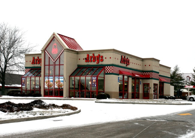

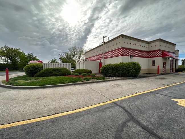
This Property Is For Sale
Property Detail
3832 Eagle View Dr
49-05-14-129-012.000-600
PT SE1/4 S14 T16 R2 BEG 229.711 W & 322.52 NE & ERLY OF SW COR P.O.B. N323.952 E164.906 S258.305 SW26.72 SW153.47 TO BEG
Restaurantdrivein
Marion
ZO01
Indiana
B and X Area of moderate flood hazard, usually the area between the limits of the 100-year and 500-year floods.
1
2024
1.13 AC
2025
Speedway
310111
Indianapolis
3,859 SF
Indianapolis-Carmel-Greenwood, IN
NEARBY LISTINGS FOR SALE OR LEASE
DEMOGRAPHICS near 3832 Eagle View Dr
1 mile
3 mile
5 mile
2025 Total Population
17,813
90,357
199,728
2030 Population
17,767
90,024
201,750
Pop Growth 2025-2030
(0.26%)
(0.37%)
+ 1.01%
Average Age
34
36
37
2025 Total Households
7,363
36,681
78,577
HH Growth 2025-2030
(0.27%)
(0.37%)
+ 0.94%
Median Household Inc
$55,077
$62,369
$65,423
Avg Household Size
2.30
2.40
2.50
2025 Avg HH Vehicles
1.00
2.00
2.00
Median Home Value
$190,368
$208,531
$224,677
Median Year Built
1981
1980
1979
Nearby Places
Map Layers
Map Styles
 Street
 Aerial
Transit
 Traffic
 Biking
Places
Listings with unknown addresses are not visible on the map
- Restaurants
- Banks
- Shops
- Fitness
- Groceries
PUBLIC TRANSPORTATION
COMMUTER RAIL
Drive
Walk
Distance
18 min
9.5 mi
AIRPORT
Indianapolis International
Drive
Walk
Distance
Indianapolis International
26 min
13.4 mi
Nearby Properties
Address
Land Use
TOTAL SIZE
Lot Size
Zoning
Address
Land Use
TOTAL SIZE
Lot Size
Zoning
56.76 AC
Address
Land Use
TOTAL SIZE
Lot Size
Zoning
4,515 SF
23.95 AC
ZO01
Address
Land Use
TOTAL SIZE
Lot Size
Zoning
5,820 SF
32.03 AC
ZO01
Address
Land Use
TOTAL SIZE
Lot Size
Zoning
415,877 SF
55.83 AC
ZO01
Address
Land Use
TOTAL SIZE
Lot Size
Zoning
1,904 SF
47.31 AC
ZO01
Address
Land Use
TOTAL SIZE
Lot Size
Zoning
3,348 SF
32.01 AC
ZO01
Address
Land Use
TOTAL SIZE
Lot Size
Zoning
3,827 SF
24.15 AC
ZO01
Address
Land Use
TOTAL SIZE
Lot Size
Zoning
3,214 SF
14.29 AC
ZO01
Address
Land Use
TOTAL SIZE
Lot Size
Zoning
3,381 SF
30.61 AC
ZO01
Address
Land Use
TOTAL SIZE
Lot Size
Zoning
3,878 SF
17.76 AC
Address
Land Use
TOTAL SIZE
Lot Size
Zoning
494 SF
36.18 AC
ZO01
Address
Land Use
TOTAL SIZE
Lot Size
Zoning
5,554 SF
23.52 AC
ZO01
Address
Land Use
TOTAL SIZE
Lot Size
Zoning
7,364 SF
9.20 AC
Address
Land Use
TOTAL SIZE
Lot Size
Zoning
30,545 SF
3.41 AC
ZO01
Address
Land Use
TOTAL SIZE
Lot Size
Zoning
3,706 SF
30.57 AC
ZO01
Address
Land Use
TOTAL SIZE
Lot Size
Zoning
7,082 SF
19.18 AC
ZO01
Address
Land Use
TOTAL SIZE
Lot Size
Zoning
4.05 AC
ZO01
Address
Land Use
TOTAL SIZE
Lot Size
Zoning
3,618 SF
31.13 AC
ZO01
Address
Land Use
TOTAL SIZE
Lot Size
Zoning
4,734 SF
30.98 AC
ZO01
Address
Land Use
TOTAL SIZE
Lot Size
Zoning
3,802 SF
12.25 AC
ZO01
Address
Land Use
TOTAL SIZE
Lot Size
Zoning
1,700 SF
40.37 AC
ZO01
Address
Land Use
TOTAL SIZE
Lot Size
Zoning
2,288 SF
21.42 AC
Address
Land Use
TOTAL SIZE
Lot Size
Zoning
73,528 SF
80 AC
ZO01
Address
Land Use
TOTAL SIZE
Lot Size
Zoning
106,651 SF
11.35 AC
ZO01
Address
Land Use
TOTAL SIZE
Lot Size
Zoning
5,184 SF
23.31 AC
ZO01
Address
Land Use
TOTAL SIZE
Lot Size
Zoning
14,662 SF
27.53 AC
Address
Land Use
TOTAL SIZE
Lot Size
Zoning
2,965 SF
29.82 AC
ZO01
Address
Land Use
TOTAL SIZE
Lot Size
Zoning
4,624 SF
26.36 AC
Address
Land Use
TOTAL SIZE
Lot Size
Zoning
65,306 SF
39.30 AC
Address
Land Use
TOTAL SIZE
Lot Size
Zoning
115,435 SF
12.97 AC
ZO01
The World's #1 Commercial Real Estate Marketplace
Connect with us
© 2026 CoStar Group
The information above has been obtained from sources believed reliable. While we do not doubt its accuracy we have not verified it and make no guarantee, warranty or representation about it. It is your responsibility to independently confirm its accuracy and completeness. Any projections, opinions, assumptions, or estimates used are for example only and do not represent the current or future performance of the property. The value of this transaction to you depends on tax and other factors which should be evaluated by your tax, financial, and legal advisors. You and your advisors should conduct a careful, independent investigation of the property to determine to your satisfaction the suitability of the property for your needs.