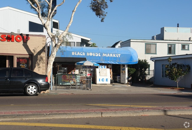
Property Record
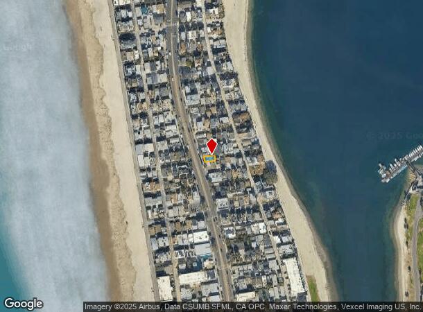
3833 Mission Blvd, San Diego, CA 92109

NEARBY LISTINGS FOR SALE OR LEASE
Property Detail
3833 Mission Blvd
423-574-20
Mission Beach
Storebuilding
BLK 208 WLY 46 FT OF SLY 25 FT MEAS ON NLY LI OF SEAGIRT CT TR 001809
AE
San Diego
06073C1592H
California
2024
0.29 AC
2025
Pacific Beach/Morena
007601
San Diego
600 SF
San Diego-Carlsbad, CA
DEMOGRAPHICS near 3833 Mission Blvd
1 Mile
3 Mile
5 Mile
2024 Total Population
16,022
88,344
235,192
2029 Population
16,597
89,120
235,688
Pop Growth 2024-2029
+ 3.59%
+ 0.88%
+ 0.21%
Average Age
38
40
41
2024 Total Households
8,668
42,830
100,075
HH Growth 2024-2029
+ 3.71%
+ 0.86%
+ 0.26%
Median Household Inc
$93,099
$99,574
$104,550
Avg Household Size
1.70
2.00
2.20
2024 Avg HH Vehicles
2.00
2.00
2.00
Median Home Value
$1,066,718
$1,066,598
$1,013,884
Median Year Built
1972
1971
1969
Nearby Places
Map Layers
Map Styles
 Street
 Aerial
- Restaurants
- Banks
- Shops
- Fitness
- Groceries
PUBLIC TRANSPORTATION
COMMUTER RAIL
Old Town Transit Center (Coaster - San Diego North County Transit District (Coaster/Sprinter/Breeze))
DRIVE
WALK
Distance
Old Town Transit Center (Coaster - San Diego North County Transit District (Coaster/Sprinter/Breeze))
10 min
4.9 mi
San Diego (Santa Fe Depot) (Coaster - San Diego North County Transit District (Coaster/Sprinter/Breeze))
DRIVE
WALK
Distance
San Diego (Santa Fe Depot) (Coaster - San Diego North County Transit District (Coaster/Sprinter/Breeze))
13 min
7.4 mi
AIRPORT
San Diego International
DRIVE
WALK
Distance
San Diego International
15 min
7.8 mi
McClellan-Palomar
DRIVE
WALK
Distance
McClellan-Palomar
41 min
29.1 mi
Freight Ports
Port of San Diego
DRIVE
WALK
Distance
Port of San Diego
18 min
11.1 mi
Nearby Properties
Address
Land Use
TOTAL SIZE
Lot Size
Zoning
Address
Land Use
TOTAL SIZE
Lot Size
Zoning
189.30 AC
M
Address
Land Use
TOTAL SIZE
Lot Size
Zoning
42.78 AC
M
Address
Land Use
TOTAL SIZE
Lot Size
Zoning
11.60 AC
RM-3-7
Address
Land Use
TOTAL SIZE
Lot Size
Zoning
18.33 AC
RS-1-7
Address
Land Use
TOTAL SIZE
Lot Size
Zoning
35.76 AC
RS-1-4
Address
Land Use
TOTAL SIZE
Lot Size
Zoning
283,689 SF
18.02 AC
M
Address
Land Use
TOTAL SIZE
Lot Size
Zoning
9.02 AC
RM-1-1
Address
Land Use
TOTAL SIZE
Lot Size
Zoning
30.21 AC
RM-2-4
Address
Land Use
TOTAL SIZE
Lot Size
Zoning
7.68 AC
RM-3-7
Address
Land Use
TOTAL SIZE
Lot Size
Zoning
5.67 AC
RS-1-7
Address
Land Use
TOTAL SIZE
Lot Size
Zoning
7.04 AC
MBPD-VC-N
Address
Land Use
TOTAL SIZE
Lot Size
Zoning
1.12 AC
CC-4-2
Address
Land Use
TOTAL SIZE
Lot Size
Zoning
1.56 AC
CC-4-2
Address
Land Use
TOTAL SIZE
Lot Size
Zoning
2.56 AC
CC-4-2
Address
Land Use
TOTAL SIZE
Lot Size
Zoning
15.50 AC
RM-4-10
Address
Land Use
TOTAL SIZE
Lot Size
Zoning
12.90 AC
RS-1-7
Address
Land Use
TOTAL SIZE
Lot Size
Zoning
8.56 AC
C
Address
Land Use
TOTAL SIZE
Lot Size
Zoning
98,561 SF
2.42 AC
RM-2-5
Address
Land Use
TOTAL SIZE
Lot Size
Zoning
74,984 SF
2.75 AC
RM-1-1
Address
Land Use
TOTAL SIZE
Lot Size
Zoning
5.49 AC
CC-4-2
Address
Land Use
TOTAL SIZE
Lot Size
Zoning
5.57 AC
RM-3-8
Address
Land Use
TOTAL SIZE
Lot Size
Zoning
41,476 SF
1.40 AC
RM-2-5
Address
Land Use
TOTAL SIZE
Lot Size
Zoning
5.23 AC
RM-3-8
Address
Land Use
TOTAL SIZE
Lot Size
Zoning
31,412 SF
3.48 AC
CC-1-3
Address
Land Use
TOTAL SIZE
Lot Size
Zoning
57,686 SF
0.14 AC
CC-4-2
Address
Land Use
TOTAL SIZE
Lot Size
Zoning
5.58 AC
RM-3-7
Address
Land Use
TOTAL SIZE
Lot Size
Zoning
59,852 SF
0.97 AC
CC-1-3
Address
Land Use
TOTAL SIZE
Lot Size
Zoning
56,214 SF
1.78 AC
CV-1-2
Address
Land Use
TOTAL SIZE
Lot Size
Zoning
4.84 AC
RM-3-7
Address
Land Use
TOTAL SIZE
Lot Size
Zoning
4.41 AC
RM-3-7
The World's #1 Commercial Real Estate Marketplace
Connect with us
© 2025 CoStar Group
The information above has been obtained from sources believed reliable. While we do not doubt its accuracy we have not verified it and make no guarantee, warranty or representation about it. It is your responsibility to independently confirm its accuracy and completeness. Any projections, opinions, assumptions, or estimates used are for example only and do not represent the current or future performance of the property. The value of this transaction to you depends on tax and other factors which should be evaluated by your tax, financial, and legal advisors. You and your advisors should conduct a careful, independent investigation of the property to determine to your satisfaction the suitability of the property for your needs.