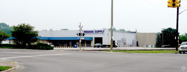
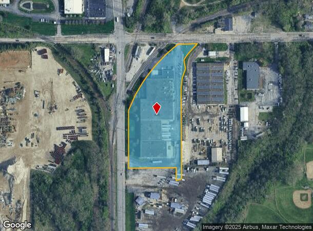
Property Record
3835 E 21St St, Indianapolis, IN 46218

Current Lease Availabilities
NEARBY LISTINGS FOR SALE OR LEASE
Property Detail
3835 E 21St St
Indianapolis-Carmel-Anderson, IN
Section 33 Township 16 R 04
49-07-33-175-013.000-101
PT NW1/4 NW1/4 S33 T16 R4 579.99 S & 6.05 E NW COR P.O.B. ARC-NE715.15 E111.85 ARC-SW167.81 S50.98 SW137.48 S511.31 SW32.07 N75.74 W335 N135 NE35.59 TO BEG 5.513 AC
Lightindustrial
Marion
2023
Indiana
2024
5.51 AC
352400
Brookside Center
73,500 SF
Indianapolis
DEMOGRAPHICS near 3835 E 21St St
1 Mile
3 Mile
5 Mile
2024 Total Population
13,060
124,872
288,901
2029 Population
13,311
126,488
290,747
Pop Growth 2024-2029
+ 1.92%
+ 1.29%
+ 0.64%
Average Age
36
37
37
2024 Total Households
5,160
54,132
124,783
HH Growth 2024-2029
+ 1.63%
+ 1.16%
+ 0.63%
Median Household Inc
$39,136
$43,663
$50,642
Avg Household Size
2.40
2.20
2.20
2024 Avg HH Vehicles
1.00
1.00
1.00
Median Home Value
$93,413
$152,210
$170,993
Median Year Built
1948
1950
1954
Nearby Places
Map Layers
Map Styles
 Street
 Aerial
- Restaurants
- Banks
- Shops
- Fitness
- Groceries
PUBLIC TRANSPORTATION
COMMUTER RAIL
Indianapolis (Cardinal - Amtrak)
DRIVE
WALK
Distance
Indianapolis (Cardinal - Amtrak)
11 min
5.6 mi
AIRPORT
Indianapolis International
DRIVE
WALK
Distance
Indianapolis International
33 min
18.7 mi
Freight Ports
Port of Toledo
DRIVE
WALK
Distance
Port of Toledo
265 min
222.2 mi
Nearby Properties
Address
Land Use
TOTAL SIZE
Lot Size
Zoning
Address
Land Use
TOTAL SIZE
Lot Size
Zoning
41.83 AC
ZO01
Address
Land Use
TOTAL SIZE
Lot Size
Zoning
25,146 SF
28.58 AC
ZO01
Address
Land Use
TOTAL SIZE
Lot Size
Zoning
309,006 SF
1.48 AC
ZO01
Address
Land Use
TOTAL SIZE
Lot Size
Zoning
18,320 SF
2.05 AC
ZO01
Address
Land Use
TOTAL SIZE
Lot Size
Zoning
4,564 SF
2.32 AC
ZO01
Address
Land Use
TOTAL SIZE
Lot Size
Zoning
3.64 AC
ZO01
Address
Land Use
TOTAL SIZE
Lot Size
Zoning
2,451 SF
0.46 AC
ZO01
Address
Land Use
TOTAL SIZE
Lot Size
Zoning
866 SF
14.33 AC
ZO01
Address
Land Use
TOTAL SIZE
Lot Size
Zoning
193,498 SF
2.69 AC
ZO01
Address
Land Use
TOTAL SIZE
Lot Size
Zoning
83,616 SF
3.57 AC
ZO01
Address
Land Use
TOTAL SIZE
Lot Size
Zoning
3.82 AC
ZO01
Address
Land Use
TOTAL SIZE
Lot Size
Zoning
2,142 SF
9.91 AC
ZO01
Address
Land Use
TOTAL SIZE
Lot Size
Zoning
147,649 SF
1.01 AC
ZO01
Address
Land Use
TOTAL SIZE
Lot Size
Zoning
3,288 SF
3.65 AC
ZO01
Address
Land Use
TOTAL SIZE
Lot Size
Zoning
713,497 SF
69.91 AC
ZO01
Address
Land Use
TOTAL SIZE
Lot Size
Zoning
87,321 SF
3.14 AC
ZO01
Address
Land Use
TOTAL SIZE
Lot Size
Zoning
61,534 SF
5.35 AC
Address
Land Use
TOTAL SIZE
Lot Size
Zoning
0.44 AC
ZO01
Address
Land Use
TOTAL SIZE
Lot Size
Zoning
3,523 SF
2.39 AC
ZO01
Address
Land Use
TOTAL SIZE
Lot Size
Zoning
11,000 SF
0.71 AC
ZO01
Address
Land Use
TOTAL SIZE
Lot Size
Zoning
13,631 SF
0.84 AC
ZO01
Address
Land Use
TOTAL SIZE
Lot Size
Zoning
925,384 SF
49.48 AC
ZO01
Address
Land Use
TOTAL SIZE
Lot Size
Zoning
39,840 SF
0.57 AC
ZO01
Address
Land Use
TOTAL SIZE
Lot Size
Zoning
2,772 SF
1.68 AC
ZO01
Address
Land Use
TOTAL SIZE
Lot Size
Zoning
156,720 SF
6.18 AC
ZO01
Address
Land Use
TOTAL SIZE
Lot Size
Zoning
27,822 SF
0.34 AC
ZO01
Address
Land Use
TOTAL SIZE
Lot Size
Zoning
8,054 SF
20.62 AC
Address
Land Use
TOTAL SIZE
Lot Size
Zoning
71,800 SF
1.88 AC
ZO01
Address
Land Use
TOTAL SIZE
Lot Size
Zoning
72,027 SF
0.80 AC
ZO01
Address
Land Use
TOTAL SIZE
Lot Size
Zoning
85,191 SF
0.90 AC
ZO01
The World's #1 Commercial Real Estate Marketplace
Connect with us
© 2026 CoStar Group
The information above has been obtained from sources believed reliable. While we do not doubt its accuracy we have not verified it and make no guarantee, warranty or representation about it. It is your responsibility to independently confirm its accuracy and completeness. Any projections, opinions, assumptions, or estimates used are for example only and do not represent the current or future performance of the property. The value of this transaction to you depends on tax and other factors which should be evaluated by your tax, financial, and legal advisors. You and your advisors should conduct a careful, independent investigation of the property to determine to your satisfaction the suitability of the property for your needs.