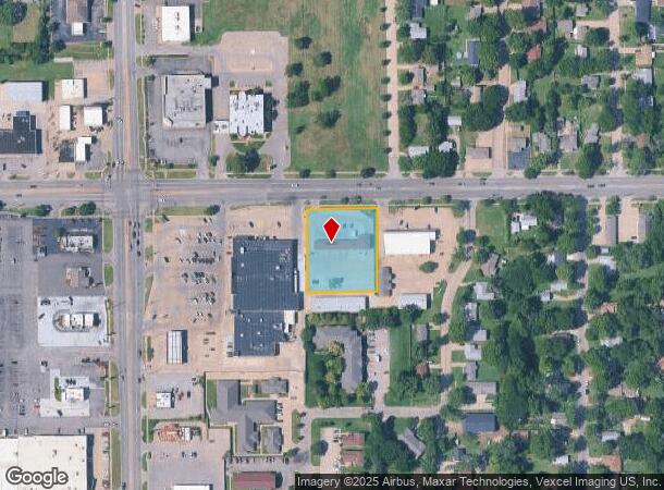
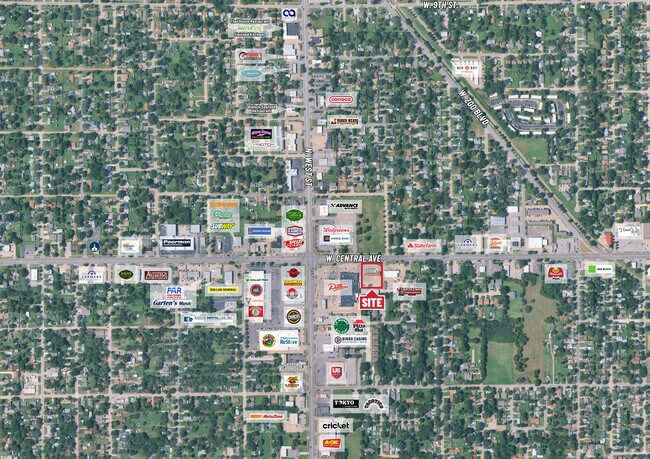
Property Record
3835 W Central Ave, Wichita, KS 67203
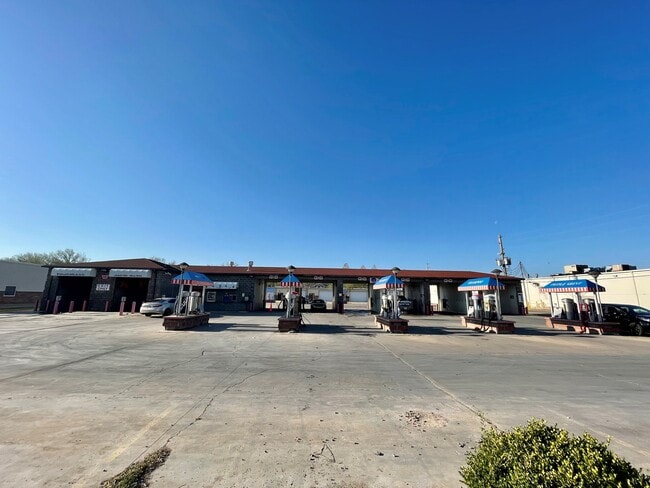
This Property Is For Sale
NEARBY LISTINGS FOR SALE OR LEASE
Property Detail
3835 W Central Ave
Wichita, KS
De Paul Add
136-24-0-22-02-003.01
N 236.77 FT W 200 FT LOT 1 BLOCK A DE PAUL ADD.
Carwash
Sedgwick
X
Kansas
20173C0334G
1
2024
1.09 AC
2025
Northwest
009000
Wichita
4,268 SF
DEMOGRAPHICS near 3835 W Central Ave
1 Mile
3 Mile
5 Mile
2024 Total Population
13,012
79,357
198,418
2029 Population
13,253
81,307
203,126
Pop Growth 2024-2029
+ 1.85%
+ 2.46%
+ 2.37%
Average Age
39
39
38
2024 Total Households
5,695
34,851
81,254
HH Growth 2024-2029
+ 1.84%
+ 2.56%
+ 2.42%
Median Household Inc
$46,105
$47,283
$50,567
Avg Household Size
2.20
2.10
2.30
2024 Avg HH Vehicles
2.00
2.00
2.00
Median Home Value
$108,648
$131,615
$135,701
Median Year Built
1960
1964
1966
Nearby Places
Map Layers
Map Styles
 Street
 Aerial
- Restaurants
- Banks
- Shops
- Fitness
- Groceries
PUBLIC TRANSPORTATION
AIRPORT
Wichita Dwight D Eisenhower Ntl
DRIVE
WALK
Distance
Wichita Dwight D Eisenhower Ntl
10 min
5.1 mi
Freight Ports
Tulsa Port Of Catoosa
DRIVE
WALK
Distance
Tulsa Port Of Catoosa
209 min
196.4 mi
Nearby Properties
Address
Land Use
TOTAL SIZE
Lot Size
Zoning
Address
Land Use
TOTAL SIZE
Lot Size
Zoning
1,675,141 SF
1,753.52 AC
LI
Address
Land Use
TOTAL SIZE
Lot Size
Zoning
216,196 SF
65.60 AC
SF-5
Address
Land Use
TOTAL SIZE
Lot Size
Zoning
515,640 SF
14.49 AC
CBD
Address
Land Use
TOTAL SIZE
Lot Size
Zoning
154,716 SF
12.18 AC
LC
Address
Land Use
TOTAL SIZE
Lot Size
Zoning
386,803 SF
13.33 AC
CBD
Address
Land Use
TOTAL SIZE
Lot Size
Zoning
456,792 SF
155.67 AC
LI
Address
Land Use
TOTAL SIZE
Lot Size
Zoning
303,559 SF
123.23 AC
SF-5
Address
Land Use
TOTAL SIZE
Lot Size
Zoning
227,462 SF
17.80 AC
TF-3
Address
Land Use
TOTAL SIZE
Lot Size
Zoning
203,580 SF
15.51 AC
B
Address
Land Use
TOTAL SIZE
Lot Size
Zoning
109,743 SF
6.10 AC
CBD
Address
Land Use
TOTAL SIZE
Lot Size
Zoning
225,962 SF
0.24 AC
CBD
Address
Land Use
TOTAL SIZE
Lot Size
Zoning
84,757 SF
1.44 AC
GC
Address
Land Use
TOTAL SIZE
Lot Size
Zoning
328,487 SF
25.95 AC
MF-29
Address
Land Use
TOTAL SIZE
Lot Size
Zoning
180,527 SF
1.93 AC
LI
Address
Land Use
TOTAL SIZE
Lot Size
Zoning
143,110 SF
1.57 AC
LI
Address
Land Use
TOTAL SIZE
Lot Size
Zoning
108,283 SF
14.80 AC
SF-5
Address
Land Use
TOTAL SIZE
Lot Size
Zoning
192,027 SF
117.94 AC
SF-20,GC,L
Address
Land Use
TOTAL SIZE
Lot Size
Zoning
62,535 SF
8.34 AC
B
Address
Land Use
TOTAL SIZE
Lot Size
Zoning
110,839 SF
0.81 AC
CBD
Address
Land Use
TOTAL SIZE
Lot Size
Zoning
169,321 SF
14.61 AC
U
Address
Land Use
TOTAL SIZE
Lot Size
Zoning
79,041 SF
19.51 AC
LC
Address
Land Use
TOTAL SIZE
Lot Size
Zoning
89,057 SF
18.91 AC
B
Address
Land Use
TOTAL SIZE
Lot Size
Zoning
35,097 SF
2.82 AC
U
Address
Land Use
TOTAL SIZE
Lot Size
Zoning
172,486 SF
25.68 AC
SF-5
Address
Land Use
TOTAL SIZE
Lot Size
Zoning
167,923 SF
18.01 AC
SF-5
Address
Land Use
TOTAL SIZE
Lot Size
Zoning
55,930 SF
10.28 AC
LI
Address
Land Use
TOTAL SIZE
Lot Size
Zoning
98,677 SF
5.62 AC
TF-3
Address
Land Use
TOTAL SIZE
Lot Size
Zoning
68,468 SF
7.17 AC
B,SF-5,GO
Address
Land Use
TOTAL SIZE
Lot Size
Zoning
136,717 SF
11.18 AC
SF-5
Address
Land Use
TOTAL SIZE
Lot Size
Zoning
85,412 SF
1.21 AC
TF-3
The World's #1 Commercial Real Estate Marketplace
Connect with us
© 2026 CoStar Group
The information above has been obtained from sources believed reliable. While we do not doubt its accuracy we have not verified it and make no guarantee, warranty or representation about it. It is your responsibility to independently confirm its accuracy and completeness. Any projections, opinions, assumptions, or estimates used are for example only and do not represent the current or future performance of the property. The value of this transaction to you depends on tax and other factors which should be evaluated by your tax, financial, and legal advisors. You and your advisors should conduct a careful, independent investigation of the property to determine to your satisfaction the suitability of the property for your needs.