Property Record
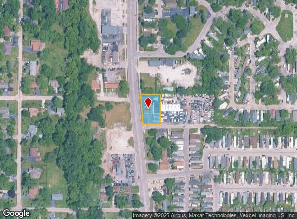
38357 N Sheridan Rd, Beach Park, IL 60087
NEARBY LISTINGS FOR SALE OR LEASE
Property Detail
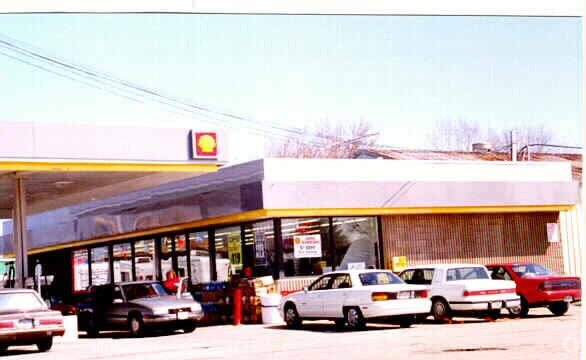
38357 N Sheridan Rd
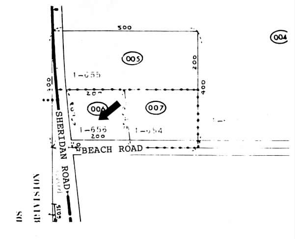
04-34-300-022
Pt Nw
Commercialbuilding
PT NW SW;PT S200N825W500DAFS,BEG AT PNT ON WLN 825S OF N WCOR,E //TO NLN 175.16,NWLY200.06TO PNT ON NLN S200N825W 500,SD PNT121.31E OF ELN SHERIDAN RD,W ALG NLN171.11TO WL
X
Lake
17097C0087L
Illinois
2023
0.45 AC
2024
Far North
860600
Chicago
2,405 SF
Chicago-Naperville-Elgin, IL-IN-WI
DEMOGRAPHICS near 38357 N Sheridan Rd
1 Mile
3 Mile
5 Mile
2024 Total Population
6,764
48,661
120,620
2029 Population
6,647
48,118
117,848
Pop Growth 2024-2029
(1.73%)
(1.12%)
(2.30%)
Average Age
40
38
38
2024 Total Households
2,465
16,762
41,553
HH Growth 2024-2029
(1.83%)
(1.33%)
(2.43%)
Median Household Inc
$60,226
$65,007
$64,004
Avg Household Size
2.70
2.80
2.80
2024 Avg HH Vehicles
2.00
2.00
2.00
Median Home Value
$169,123
$159,790
$171,170
Median Year Built
1980
1965
1968
Nearby Places
Map Layers
Map Styles
 Street
 Aerial
- Restaurants
- Banks
- Shops
- Fitness
- Groceries
PUBLIC TRANSPORTATION
COMMUTER RAIL
Zion Station (Union Pacific North Line - Northeast Illinois Regional Commuter Railroad (Metra))
DRIVE
WALK
Distance
Zion Station (Union Pacific North Line - Northeast Illinois Regional Commuter Railroad (Metra))
6 min
2.5 mi
Waukegan Station (Union Pacific North Line - Northeast Illinois Regional Commuter Railroad (Metra))
DRIVE
WALK
Distance
Waukegan Station (Union Pacific North Line - Northeast Illinois Regional Commuter Railroad (Metra))
8 min
4.4 mi
Freight Ports
Port Milwaukee
DRIVE
WALK
Distance
Port Milwaukee
60 min
48.3 mi
Nearby Properties
Address
Land Use
TOTAL SIZE
Lot Size
Zoning
Address
Land Use
TOTAL SIZE
Lot Size
Zoning
32,000 SF
0.92 AC
Address
Land Use
TOTAL SIZE
Lot Size
Zoning
19,308 SF
9.56 AC
Address
Land Use
TOTAL SIZE
Lot Size
Zoning
5,690 SF
93.61 AC
Address
Land Use
TOTAL SIZE
Lot Size
Zoning
18.23 AC
Address
Land Use
TOTAL SIZE
Lot Size
Zoning
3,278,145 SF
10.77 AC
Address
Land Use
TOTAL SIZE
Lot Size
Zoning
11,760 SF
203.72 AC
Address
Land Use
TOTAL SIZE
Lot Size
Zoning
1,350,048 SF
12.88 AC
Address
Land Use
TOTAL SIZE
Lot Size
Zoning
1,252,125 SF
3.89 AC
Address
Land Use
TOTAL SIZE
Lot Size
Zoning
320,050 SF
0.96 AC
Address
Land Use
TOTAL SIZE
Lot Size
Zoning
456,332 SF
5.12 AC
Address
Land Use
TOTAL SIZE
Lot Size
Zoning
70,268 SF
8.66 AC
Address
Land Use
TOTAL SIZE
Lot Size
Zoning
66,140 SF
0.88 AC
Address
Land Use
TOTAL SIZE
Lot Size
Zoning
0.24 AC
Address
Land Use
TOTAL SIZE
Lot Size
Zoning
0.36 AC
Address
Land Use
TOTAL SIZE
Lot Size
Zoning
1,003 SF
25 AC
Address
Land Use
TOTAL SIZE
Lot Size
Zoning
95,368 SF
7.07 AC
Address
Land Use
TOTAL SIZE
Lot Size
Zoning
34,476 SF
0.24 AC
Address
Land Use
TOTAL SIZE
Lot Size
Zoning
Address
Land Use
TOTAL SIZE
Lot Size
Zoning
0.40 AC
Address
Land Use
TOTAL SIZE
Lot Size
Zoning
55,087 SF
0.57 AC
Address
Land Use
TOTAL SIZE
Lot Size
Zoning
88,640 SF
1.01 AC
Address
Land Use
TOTAL SIZE
Lot Size
Zoning
85,238 SF
1.14 AC
Address
Land Use
TOTAL SIZE
Lot Size
Zoning
276,144 SF
6.85 AC
Address
Land Use
TOTAL SIZE
Lot Size
Zoning
Address
Land Use
TOTAL SIZE
Lot Size
Zoning
88,332 SF
5.32 AC
Address
Land Use
TOTAL SIZE
Lot Size
Zoning
86,978 SF
2.81 AC
Address
Land Use
TOTAL SIZE
Lot Size
Zoning
0.24 AC
Address
Land Use
TOTAL SIZE
Lot Size
Zoning
17.39 AC
Address
Land Use
TOTAL SIZE
Lot Size
Zoning
65,440 SF
0.16 AC
Address
Land Use
TOTAL SIZE
Lot Size
Zoning
36,083 SF
1.58 AC
The World's #1 Commercial Real Estate Marketplace
Connect with us
© 2025 CoStar Group
The information above has been obtained from sources believed reliable. While we do not doubt its accuracy we have not verified it and make no guarantee, warranty or representation about it. It is your responsibility to independently confirm its accuracy and completeness. Any projections, opinions, assumptions, or estimates used are for example only and do not represent the current or future performance of the property. The value of this transaction to you depends on tax and other factors which should be evaluated by your tax, financial, and legal advisors. You and your advisors should conduct a careful, independent investigation of the property to determine to your satisfaction the suitability of the property for your needs.