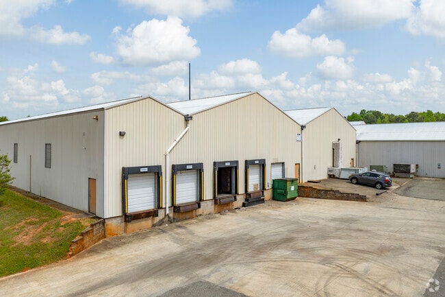
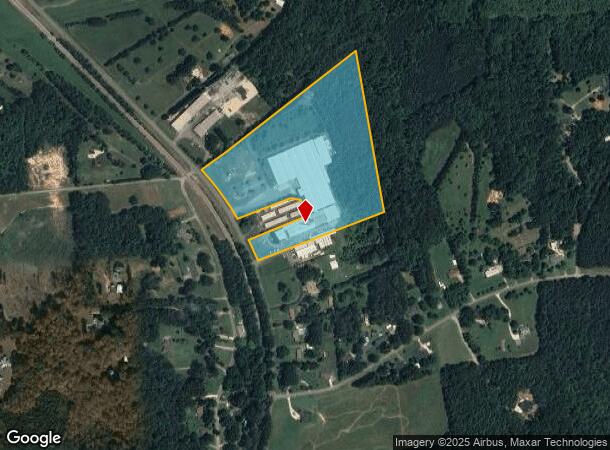
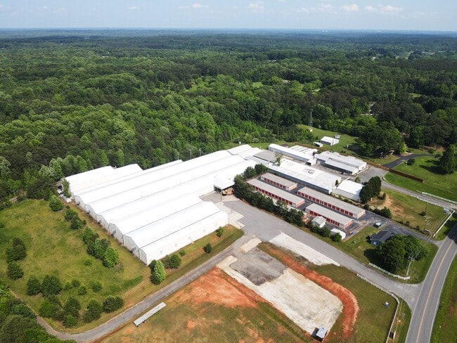
Property Record
3838 Charles Raper Jonas Hwy, Stanley, NC 28164
Current Lease Availabilities
NEARBY LISTINGS FOR SALE OR LEASE
Property Detail
3838 Charles Raper Jonas Hwy
165322
13 022 024 02 000
Industrialgeneral
Gaston
X
North Carolina
3710366000K
18.06 AC
2025
Gaston County
2025
Charlotte
030209
Charlotte-Concord-Gastonia, NC-SC
142,850 SF
DEMOGRAPHICS near 3838 Charles Raper Jonas Hwy
1 mile
3 mile
5 mile
2024 Total Population
944
10,459
22,610
2029 Population
1,005
11,317
24,737
Pop Growth 2024-2029
+ 6.46%
+ 8.20%
+ 9.41%
Average Age
41
41
42
2024 Total Households
391
4,178
8,908
HH Growth 2024-2029
+ 6.65%
+ 8.45%
+ 9.64%
Median Household Inc
$54,710
$58,619
$60,226
Avg Household Size
2.40
2.50
2.50
2024 Avg HH Vehicles
2.00
2.00
2.00
Median Home Value
$186,403
$195,645
$204,237
Median Year Built
1979
1982
1986
Nearby Places
Map Layers
Map Styles
 Street
 Aerial
Transit
 Traffic
 Biking
Places
Listings with unknown addresses are not visible on the map
- Restaurants
- Banks
- Shops
- Fitness
- Groceries
PUBLIC TRANSPORTATION
AIRPORT
Charlotte/Douglas International
Drive
Walk
Distance
Charlotte/Douglas International
35 min
18.9 mi
Concord-Padgett Regional
Drive
Walk
Distance
Concord-Padgett Regional
41 min
28.5 mi
Freight Ports
North Charleston Terminal
Drive
Walk
Distance
North Charleston Terminal
247 min
214.8 mi
Nearby Properties
Address
Land Use
TOTAL SIZE
Lot Size
Zoning
Address
Land Use
TOTAL SIZE
Lot Size
Zoning
135,468 SF
35.34 AC
PUB01
Address
Land Use
TOTAL SIZE
Lot Size
Zoning
76,455 SF
36.80 AC
Address
Land Use
TOTAL SIZE
Lot Size
Zoning
7,490 SF
10.10 AC
HCAR4
Address
Land Use
TOTAL SIZE
Lot Size
Zoning
12,000 SF
5.90 AC
SHOP5
Address
Land Use
TOTAL SIZE
Lot Size
Zoning
30,272 SF
9.13 AC
R20
Address
Land Use
TOTAL SIZE
Lot Size
Zoning
76,602 SF
11.48 AC
PUB01
Address
Land Use
TOTAL SIZE
Lot Size
Zoning
59,315 SF
10.31 AC
CHUR2
Address
Land Use
TOTAL SIZE
Lot Size
Zoning
4,676 SF
15.14 AC
R-SF & R-R
Address
Land Use
TOTAL SIZE
Lot Size
Zoning
61,359 SF
12.30 AC
PUB01
Address
Land Use
TOTAL SIZE
Lot Size
Zoning
40,937 SF
4.44 AC
MRKT4
Address
Land Use
TOTAL SIZE
Lot Size
Zoning
5,366 SF
125.67 AC
R1
Address
Land Use
TOTAL SIZE
Lot Size
Zoning
1,834 SF
8.42 AC
R1
Address
Land Use
TOTAL SIZE
Lot Size
Zoning
4,264 SF
20.87 AC
R-T
Address
Land Use
TOTAL SIZE
Lot Size
Zoning
1,260 SF
3.80 AC
OFF01
Address
Land Use
TOTAL SIZE
Lot Size
Zoning
30,592 SF
4.03 AC
CHUR2
Address
Land Use
TOTAL SIZE
Lot Size
Zoning
7,267 SF
63.40 AC
Address
Land Use
TOTAL SIZE
Lot Size
Zoning
8,980 SF
8.02 AC
CHUR2
Address
Land Use
TOTAL SIZE
Lot Size
Zoning
27,609 SF
3.89 AC
HCAR3
Address
Land Use
TOTAL SIZE
Lot Size
Zoning
1,935 SF
2.16 AC
APT02
Address
Land Use
TOTAL SIZE
Lot Size
Zoning
10,125 SF
1.18 AC
RET05
Address
Land Use
TOTAL SIZE
Lot Size
Zoning
8,222 SF
2.08 AC
CHUR5
Address
Land Use
TOTAL SIZE
Lot Size
Zoning
5,472 SF
1.40 AC
GARG1
Address
Land Use
TOTAL SIZE
Lot Size
Zoning
5,908 SF
1.36 AC
GB
Address
Land Use
TOTAL SIZE
Lot Size
Zoning
10,341 SF
5.28 AC
CHUR2
Address
Land Use
TOTAL SIZE
Lot Size
Zoning
12,096 SF
91.24 AC
PUB08
Address
Land Use
TOTAL SIZE
Lot Size
Zoning
60,901 SF
3.90 AC
INDS1
Address
Land Use
TOTAL SIZE
Lot Size
Zoning
21,000 SF
21.08 AC
DAYC1
Address
Land Use
TOTAL SIZE
Lot Size
Zoning
1,784 SF
288.18 AC
R1
Address
Land Use
TOTAL SIZE
Lot Size
Zoning
2,781 SF
80.69 AC
R1H
The World's #1 Commercial Real Estate Marketplace
Connect with us
© 2026 CoStar Group
The information above has been obtained from sources believed reliable. While we do not doubt its accuracy we have not verified it and make no guarantee, warranty or representation about it. It is your responsibility to independently confirm its accuracy and completeness. Any projections, opinions, assumptions, or estimates used are for example only and do not represent the current or future performance of the property. The value of this transaction to you depends on tax and other factors which should be evaluated by your tax, financial, and legal advisors. You and your advisors should conduct a careful, independent investigation of the property to determine to your satisfaction the suitability of the property for your needs.