Property Record
38382 Dexter Rd, Dexter, OR 97431
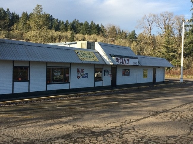

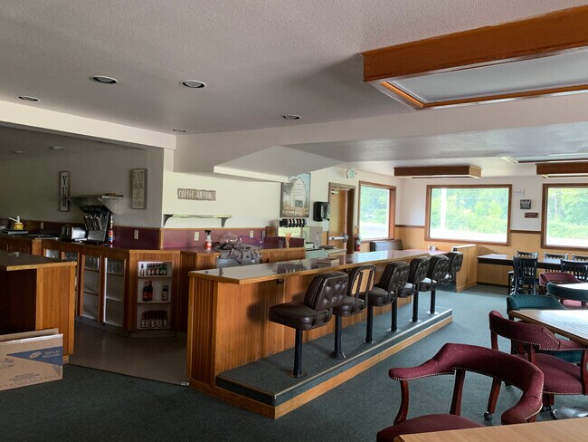

Property Detail
38382 Dexter Rd
Eugene-Springfield, OR
TL 02400
0813640
Lane
Commercialbuilding
Oregon
RC
2400
B and X Area of moderate flood hazard, usually the area between the limits of the 100-year and 500-year floods.
1 AC
2025
Lane County
2025
Portland
001600
NEARBY LISTINGS FOR SALE OR LEASE
-
-
View all Dexter listings for sale on LoopNet.com
DEMOGRAPHICS near 38382 Dexter Rd
1 mile
3 mile
5 mile
2025 Total Population
339
3,938
6,821
2030 Population
337
3,944
6,810
Pop Growth 2025-2030
(0.59%)
+ 0.15%
(0.16%)
Average Age
46
45
45
2025 Total Households
124
1,457
2,523
HH Growth 2025-2030
0.00%
+ 0.21%
(0.12%)
Median Household Inc
$84,615
$84,375
$87,961
Avg Household Size
2.60
2.60
2.60
2025 Avg HH Vehicles
3.00
3.00
3.00
Median Home Value
$474,999
$446,202
$513,619
Median Year Built
1974
1975
1976
Nearby Places
Map Layers
Map Styles
 Street
 Aerial
Transit
 Traffic
 Biking
Places
Listings with unknown addresses are not visible on the map
- Restaurants
- Banks
- Shops
- Fitness
- Groceries
PUBLIC TRANSPORTATION
AIRPORT
Mahlon Sweet Field
Drive
Walk
Distance
Mahlon Sweet Field
41 min
26.6 mi
SALE & LEASE HISTORY
LISTING DATE
SALE/LEASE

Jan 19, 2017
For Sale
Feb 22, 2021
For Sale
Nearby Properties
Address
Land Use
TOTAL SIZE
Lot Size
Zoning
Address
Land Use
TOTAL SIZE
Lot Size
Zoning
4.67 AC
PL
Address
Land Use
TOTAL SIZE
Lot Size
Zoning
2,216 SF
21.28 AC
F1
Address
Land Use
TOTAL SIZE
Lot Size
Zoning
Address
Land Use
TOTAL SIZE
Lot Size
Zoning
6,311 SF
6.42 AC
F1
Address
Land Use
TOTAL SIZE
Lot Size
Zoning
0.62 AC
RC
Address
Land Use
TOTAL SIZE
Lot Size
Zoning
5,496 SF
4.70 AC
RR5
Address
Land Use
TOTAL SIZE
Lot Size
Zoning
5,979 SF
33.59 AC
E25
Address
Land Use
TOTAL SIZE
Lot Size
Zoning
920 SF
19.28 AC
E25
Address
Land Use
TOTAL SIZE
Lot Size
Zoning
2.05 AC
F1
Address
Land Use
TOTAL SIZE
Lot Size
Zoning
5 AC
F2
Address
Land Use
TOTAL SIZE
Lot Size
Zoning
1.35 AC
RR5
Address
Land Use
TOTAL SIZE
Lot Size
Zoning
1.94 AC
PL
Address
Land Use
TOTAL SIZE
Lot Size
Zoning
6,852 SF
5 AC
F2
Address
Land Use
TOTAL SIZE
Lot Size
Zoning
1.11 AC
RC
Address
Land Use
TOTAL SIZE
Lot Size
Zoning
5,263 SF
74.56 AC
E25
Address
Land Use
TOTAL SIZE
Lot Size
Zoning
4,512 SF
5 AC
F1
Address
Land Use
TOTAL SIZE
Lot Size
Zoning
3,033 SF
37.33 AC
E40
Address
Land Use
TOTAL SIZE
Lot Size
Zoning
0.88 AC
PL
Address
Land Use
TOTAL SIZE
Lot Size
Zoning
3,975 SF
6 AC
E40
Address
Land Use
TOTAL SIZE
Lot Size
Zoning
3,987 SF
5 AC
E40
Address
Land Use
TOTAL SIZE
Lot Size
Zoning
7,546 SF
5 AC
Address
Land Use
TOTAL SIZE
Lot Size
Zoning
1.73 AC
F2
Address
Land Use
TOTAL SIZE
Lot Size
Zoning
1.60 AC
PL
Address
Land Use
TOTAL SIZE
Lot Size
Zoning
2,386 SF
7.30 AC
E25
Address
Land Use
TOTAL SIZE
Lot Size
Zoning
4,407 SF
5 AC
E40
Address
Land Use
TOTAL SIZE
Lot Size
Zoning
1.16 AC
F1
Address
Land Use
TOTAL SIZE
Lot Size
Zoning
3,741 SF
5 AC
E40
Address
Land Use
TOTAL SIZE
Lot Size
Zoning
197.54 AC
E30
Address
Land Use
TOTAL SIZE
Lot Size
Zoning
4,552 SF
32.93 AC
E40
The World's #1 Commercial Real Estate Marketplace
Connect with us
© 2026 CoStar Group
The information above has been obtained from sources believed reliable. While we do not doubt its accuracy we have not verified it and make no guarantee, warranty or representation about it. It is your responsibility to independently confirm its accuracy and completeness. Any projections, opinions, assumptions, or estimates used are for example only and do not represent the current or future performance of the property. The value of this transaction to you depends on tax and other factors which should be evaluated by your tax, financial, and legal advisors. You and your advisors should conduct a careful, independent investigation of the property to determine to your satisfaction the suitability of the property for your needs.